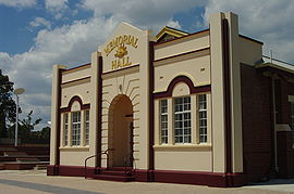
The town was originally known as Drakesbrook, and was first settled by John Fouracre in 1891. A railway station on the Pinjarra to Picton Junction railway line with the name "Drake's Brook", named after William Henry Drake, an Assistant Commissioner General and original landholder in the area (1847), opened in September 1893 and the town was surveyed and gazetted by March 1895. The surveyor-general of the day recommended the name change from Drake's Brook to Drakesbrook as "it is more euphonious and would look better on the plan". The change was made official in October 1896, and in the same year a post office was opened.
In 1895 Joseph McDowell built a timber mill in the northern end of the surveyed townsite at present-day Mill Street, near which a railway siding was opened. Due to the unpopularity of the initial subdivision, new lots were surveyed near the mill, which became known as Waroona. This name was most probably a corruption of Werroona near the Bendigo goldfields in Victoria, believed to be McDowell's hometown. (The original word meant "resting place" in the Djadjawurrung language.)
The town was boosted by the building of the railway, for which local timber was milled for sleepers. It catered to the needs of the mill workers with a post office, general store, school, blacksmith, a number of hotels come boarding houses, churches, doctor and dentist. The farms supplied butter, fruit and vegetables for the men of the mills, and chaff for the horse teams that hauled the logs.[3] In March 1899, McDowell's Siding was converted into Waroona Station, and figures for rail traffic on the South Western Railway reveal that total earnings of outgoing traffic from Waroona was the highest of any station from 1904 to 1947.
Development was confused in the early years as Drakesbrook and Waroona both persisted in usage – in the 1890s referring to the separate towns 2 kilometres (1.2mi) apart (of which Waroona was the focus of most major development) but often coming to be used interchangeably. The two settlements gradually merged into one town, which became known as Waroona. The name was officially changed in 1946.[4]
The first Waroona Dam, now the Drakesbrook Dam, was built in 1931–32 under the guidance of the Waroona Irrigation District by unemployed people on work programmes during the Great Depression. The completion of the dam, together with drainage and irrigation works, were the start of a period of considerable development in Waroona. The present Waroona Dam, further up in the hills, was officially opened in 1966.
The railway cottages, built in 1896 to accommodate railway employees (until about 1970), and which have survived to the modern day and have been heritage-listed, are the only surviving timber and iron clad platelayers' cottages in Western Australia and are among a very small number of nineteenth-century timber and iron railway houses extant in 2003.[5]
The local dairy industry included a local Nestlé milk factory, which was functional until the mid-20th century. It has since become a private compound for heavy machinery.
2016 bushfire
Samson Brook Bridge before being destroyed by the fire in 2016
Following a lightning strike near Nanga Brook a bushfire broke out that caused extensive damage to bushland, properties and infrastructure in the area including the collapse of the Samson Brook bridge on the South Western Highway. The fire started early on 6 January 2016 and as at 4pm on 7 January it continued to burn out of control with in excess of 21,000 hectares (52,000 acres) burnt and residents being evacuated to facilities in Pinjarra or Australind. The towns of Yarloop and Harvey were also threatened by the fire with residents urged to evacuate; most of Yarloop was destroyed by it. The town of Preston Beach was isolated with residents sheltering on the beach or evacuated by boat.[7][8]
Present day
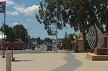
South Western Highway, Waroona
Waroona is located on South Western Highway, 113 kilometres (70mi) south of Perth at the foot of the Darling Range and has a population of about 1,800. Agriculture (including dairying) and tourism are the major economic activities, and an irrigation system from the Drakesbrook Weir waters the town and nearby agricultural areas. Every October the town hosts the Waroona Agricultural Show.
Waroona has a recreation centre and two public sports ovals. Until the 1990s, an abattoir operated from the town, but one in nearby Harvey now fulfils this purpose, and some Waroona residents work there. Shopping needs are met by local businesses and supermarkets. Nearby Waroona Dam and Drakesbrook Weir are now popular tourist and picnic spots and camping grounds, offering activities such as canoeing and water-skiing. Several heritage trails and art and craft shops are also located in Waroona. The shire president is Mike Walmsley.
Education
There are two local schools: St Joseph's Primary School (Catholic) and Waroona District High School, which is a primary (elementary) school including kindergarten and junior high school. Senior high school is usually completed by local students in the towns of Pinjarra, Harvey and Mandurah.
On 26 July 2005 the Drakesbrook School House, first opened in 1898 as a one-room school and located in Centennial Park, was burnt down. It had been closed since the 1980s but maintained as a historic site. After police investigations, the remaining structure was removed, but a year later the council approved a memorial to the school to be built on the site in consultation with the Waroona Historical Society.[9]
Art and culture
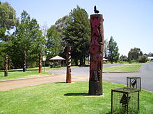
Waroona heritage pole outside the visitor centre
The Waroona Visitor Centre is the location of a local art and craft gallery. Public artwork has been installed around the town site since 1998, as part of the Alcoa and Fremantle Arts Centre "Art in the Community" project. These include the "forest" of heritage bush poles near the northern tourist information bay, which are jarrah poles that have been carved and painted, as well as a 24-tonne (53,000lb) concrete sofa with patchwork quilt, knitted by more than 60 local women, with pieces depicting life in Waroona. The Waroona Heritage Trail – which can be walked or driven – passes by historic buildings and sites, and is marked by artistic bollards. The trail's guidebook is illustrated by sketches of the sites drawn by local artists.[10]
Transport
Road
The main road route through the town is the South Western Highway (Route 20; Perth to Bunbury via Pinjarra and Harvey).
The Peel region is one of the nine regions of Western Australia. It is located on the west coast of Western Australia, about 75 km (47 mi) south of the state capital, Perth. It consists of the City of Mandurah, and the Shires of Boddington, Murray, Serpentine-Jarrahdale and Waroona.
The Australind is a currently suspended rural passenger train service in Western Australia operated by Transwa on the South Western Railway between Perth and Bunbury.
Yarloop is a town in the South West of Western Australia along the South Western Highway, between Waroona and Harvey. At the 2016 census, Yarloop had a population of 395. On 7 January 2016 a bushfire destroyed most of the town.
Pinjarra is a town in the Peel region of Western Australia along the South Western Highway, 82 kilometres (51 mi) from the state capital, Perth and 21 kilometres (13 mi) south-east of the coastal city of Mandurah. Its local government area is the Shire of Murray. At the 2016 census, Pinjarra had a population of 4910.
Cookernup is a town in the South West of Western Australia near the South Western Highway, between Waroona and Harvey.
Harvey is a town located in the South West of Western Australia along the South Western Highway, 140 kilometres (87 mi) south of Perth, between Pinjarra and Bunbury. It has a population of 2,750. Harvey Town is known for its dairy industry and oranges.
North Dandalup is a small town in the Peel region of Western Australia along the South Western Highway between Serpentine and Pinjarra. Its local government area is the Shire of Murray. At the 2011 census, North Dandalup had a population of 346.
South Western Highway is a highway in the South West region of Western Australia connecting Perth's southeast with Walpole. It is a part of the Highway 1 network for most of its length. It is about 406 kilometres (252 mi) long.
Wagerup is a town located in the Peel region of Western Australia just off the South Western Highway. It is located between Waroona and Harvey, 12 km (7.5 mi) south of Waroona.
Australind is a town in Western Australia, located 12 km north-east of Bunbury's central business district. Its local government area is the Shire of Harvey. At the 2016 census, Australind had a population of 14,539.
Wokalup is a town located in the South West region of Western Australia along the South Western Highway, between Harvey and Brunswick Junction. At the 2006 census, Wokalup had a population of 449.
Nanga Brook is a former town located in the Peel region of Western Australia in the Lane Poole Reserve between Dwellingup and Waroona.
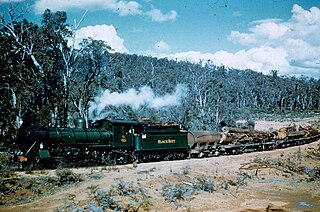
Banksiadale is a locality and former town in the Peel region of Western Australia north of Dwellingup. Its local government area is the Shire of Murray.
The Shire of Waroona is a local government area in the Peel region of Western Australia between Mandurah and Harvey and about 110 kilometres (68 mi) south of Perth, the state capital. The Shire covers an area of about 835 km² (322 mi²) and its seat of government is the town of Waroona.
The South Western Railway, also known as the South West Main Line, is the main railway route between Perth and Bunbury in Western Australia.
The Yarloop Workshops was a railway and timber mill machinery workshop, situated in the town of Yarloop, Western Australia.
Harvey railway station is located on the South Western Railway in Western Australia. It serves the town of Harvey.
The most destructive bushfire season in terms of property loss since the 2008–09 Australian bushfire season, occurred in the summer of 2015–16, with the loss of 408 houses and at least 500 non-residential buildings as a result of wild fires between 1 June 2015 and 31 May 2016. The season also suffered the most human fatalities since the 2008–09 Australian bushfire season; 6 died in Western Australia, 2 in South Australia and 1 in New South Wales. 8 deaths were as a direct result of fire, and a volunteer firefighter died due to unrelated health complications while on duty.
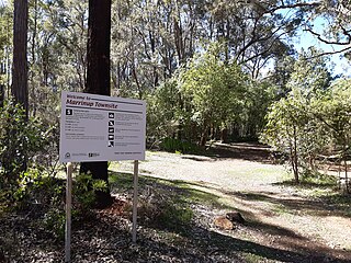
Marrinup is a ghost town in the Peel region of Western Australia between Dwellingup and Pinjarra. Its local government area is the Shire of Murray. The town was destroyed in the 1961 bushfires and the townsite is now used as a campground. The ruins of the townsite are heritage listed. Little remains of the town other than an old bridge over Marrinup Creek and some wooden railway sleepers.
The 2016 Waroona-Yarloop bushfire started in the east in the forests of the Darling Scarp before reaching the Swan Coastal Plain and continued westwards until it reached the Indian Ocean. It started as a lightning strike that caused two fires in the Lane Poole Reserve state forest near Dwellingup, Western Australia on 5 January 2016 and then burnt close to Waroona and then through the historical town of Yarloop, destroying it, before continuing southwards towards the outskirts of the town of Harvey and westwards to Preston Beach. Around 70,000 ha of land was burnt, two people died and at least 166 buildings were destroyed in Yarloop alone with only ninety buildings surviving. In total 181 buildings and structures were lost with the total cost of fighting the fire and the cost of the damage and the loss resulting estimated at $155 million.
This page is based on this Wikipedia article Text is available under the CC BY-SA 4.0 license; additional terms may apply. Images, videos and audio are available under their respective licenses.