Banksiadale, Western Australia

Last updated

Banksiadale
Western Australia
Cs270, Banksiadale line, ca. 1960.jpg
A Banksiadale log train, ca. 1960.
Banksiadale, Western Australia
Coordinates 32°37′59″S116°06′25″E / 32.633°S 116.107°E / -32.633; 116.107
Population0 (SAL 2016) [1] [2]
Established1910
Postcode(s) 6213
Area239.5 km2 (92.5 sq mi)
Location
LGA(s) Shire of Murray
State electorate(s) Murray-Wellington
Federal division(s) Canning
Localities around Banksiadale:
Fairbridge Whittaker Solus
Oakley Banksiadale Mount Wells
Marrinup Inglehope & Holyoake Wuraming

Banksiadale is a locality and former town in the Peel region of Western Australia north of Dwellingup. Its local government area is the Shire of Murray.

Contents

History

Banksiadale is named after the plant genus Banksia , as the area consists of jarrah forest with unusually thick understorey of Banksia grandis (Bull Banksia). For over 50 years, the area was home to a small timber milling town.

The Hotham Valley railway (operated by WAGR) was opened from Pinjarra to Dwellingup in 1910 to access the jarrah and marri timber in the area. In 1911, a site to produce timber for a wide range of general railway purposes was selected 8 km north of Dwellingup and a railway was opened to it in January 1912. The No. 2 Railway Mill was built in the same year and began operations in December 1912.

By 1917, a network of railways covering 33 km of track extended from Banksiadale to the areas in which timber was being felled. In the year of 1926 alone, the Banksiadale mill produced 185,000 sleepers, and 6,347 other loads, of which the WAGR utilised a little more than 50%, the balance being sold or stacked. [3]

By 1946, the local timber had been exhausted and WAGR obtained another concession at Asquith Block, 30 km east of Harvey upstream from Nanga Brook, which was being worked by Millar Brothers. A railway from Asquith Block was completed in 1948 (including a 28-span timber trestle bridge which is now heritage listed). In the early 1950s, Asquith logs were brought to Banksiadale by G class locomotives (later replaced by more modern and powerful Cs class) and the sawn timber was returned to Dwellingup. [4]

The Dwellingup fires in January and February 1961 devastated the countryside but the Banksiadale townsite and timber mill escaped damage. The mill only, was burnt down in 1963 and was not rebuilt as it was on land destined to be flooded when the South Dandalup Dam was constructed. Many of the mill houses were transferred to the Dwellingup townsite and private homes were sold to be demolished. Railways were subsequently removed, but ARHS special excursion trains took visitors into the area in the 1960s.

Present day

Its main feature is Lake Banksiadale, which is dammed by the South Dandalup Dam. Most of the area is declared disease risk area for Phytophthora cinnamomi dieback.

Related Research Articles

<span class="mw-page-title-main">Hotham Valley Railway</span>

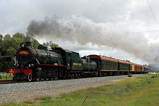
The Hotham Valley Tourist Railway is a tourist and heritage railway in the Peel region of Western Australia.

<span class="mw-page-title-main">Dwellingup, Western Australia</span> Town in Western Australia

Dwellingup is a town in Western Australia located in a timber and fruitgrowing area in the Darling Range east-south-east of Pinjarra. At the 2011 census, Dwellingup had a population of 383.

<span class="mw-page-title-main">North Dandalup, Western Australia</span> Town in Western Australia

North Dandalup is a small town in the Peel region of Western Australia along the South Western Highway between Serpentine and Pinjarra. Its local government area is the Shire of Murray. At the 2011 census, North Dandalup had a population of 346.

<span class="mw-page-title-main">Boddington, Western Australia</span> Town in Western Australia

Boddington is a town and shire in the Peel region of Western Australia, located 120 kilometres (75 mi) south-east of Perth. The town sits on the road from Pinjarra to Williams on the Hotham River. The population of the town was 1,844 at the 2016 Census.

<span class="mw-page-title-main">Jarrahdale, Western Australia</span> Suburb of Perth, Western Australia

Jarrahdale is a small historic town located 45 km south-east of Perth, Western Australia in the Darling Range. The name is derived from its situation in a jarrah forest. Established in the late 1800s as the state's first major timber milling operation, it played a key role in the development of Western Australia through the exportation of jarrah around the world. At the 2016 census, Jarrahdale had a population of 1,192. Since 2001, the historic precinct has been managed by the state's National Trust organisation alongside private residential and tourism-oriented developments.

<span class="mw-page-title-main">Nanga Brook, Western Australia</span> Town in Western Australia

Nanga Brook is a former town located in the Peel region of Western Australia in the Lane Poole Reserve between Dwellingup and Waroona.

Millbridge is a northeastern suburb of Bunbury, Western Australia, adjoining Eaton 9 km from the centre of Bunbury. At the 2021 census, it had a population of 2,736. Its local government area is the Shire of Dardanup.

Dwarda is a small town in the Wheatbelt region of Western Australia, 11 kilometres (7 mi) south of the town of Wandering on the Hotham River.

<span class="mw-page-title-main">Lake Banksiadale</span> Man-made lake in Western Australia

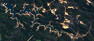
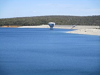
Lake Banksiadale is a man-made reservoir located in the Peel region of Western Australia. It is located about 6 kilometres (3.7 mi) north-east of Dwellingup in the locality of Banksiadale, Shire of Murray. Since 1971 it has been the site of the South Dandalup Dam, the largest dam supplying water to Perth, Western Australia's capital city.

<span class="mw-page-title-main">South Dandalup Dam</span> Dam in Western Australia

South Dandalup Dam is a dam in Western Australia. It is located where the South Dandalup River flows out of Lake Banksiadale. The dam was built in 1971 in response to rapid population growth in Perth, Western Australia's capital city, and a resources boom in the Pilbara.

<span class="mw-page-title-main">Shire of Murray</span> Local government area in Western Australia

The Shire of Murray is a local government area of Western Australia. It has an area of 1,710.1 square kilometres (660.3 sq mi) and is located in the Peel Region about 80 kilometres (50 mi) south of the Perth central business district.

<span class="mw-page-title-main">Shire of Boddington</span> Local government area in Western Australia

The Shire of Boddington is a local government area in the Peel region of Western Australia, about 120 kilometres (75 mi) south-east of the state capital, Perth. The Shire covers an area of 1,901 square kilometres (734 sq mi), and its seat of government is the town of Boddington.

<span class="mw-page-title-main">South Western Railway, Western Australia</span> Main railway route between Perth and Bunbury in Western Australia

The South Western Railway, also known as the South West Main Line, is the main railway route between Perth and Bunbury in Western Australia.

<span class="mw-page-title-main">Karridale, Western Australia</span> Town in Western Australia

Karridale is a small township in the south-west of Western Australia. It is located just north of Augusta and south of Margaret River between Caves Road and Bussell Highway. A newer township was built a short distance north east of the original Old Karridale following fires that destroyed the town in 1961. At the 2006 census, Karridale had a population of 285.

<span class="mw-page-title-main">WAGR W class</span>

The WAGR W class is a class of 4-8-2 steam locomotives operated by the Western Australian Government Railways (WAGR) between 1951 and 1972.

Redmond is a town in the Great Southern region of Western Australia. It is located 399 km south-south-east of Perth and the closest populated town is Albany.

Meelon is a small townsite in the Peel region of Western Australia, located between Pinjarra and Dwellingup within the Shire of Murray. At the 2011 census, Meelon had a population of 224.

<span class="mw-page-title-main">Marrinup, Western Australia</span> Ghost town in Western Australia

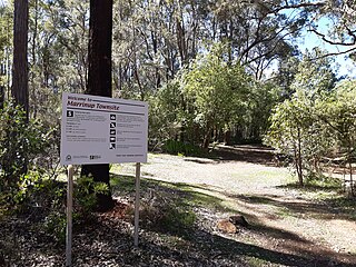
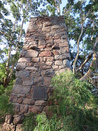
Marrinup is a ghost town in the Peel region of Western Australia between Dwellingup and Pinjarra. Its local government area is the Shire of Murray. The town was destroyed in the 1961 bushfires and the townsite is now used as a campground. The ruins of the townsite are heritage listed. Little remains of the town other than an old bridge over Marrinup Creek and some wooden railway sleepers.

Holyoake is a rural locality of the Shire of Murray in the Peel Region of Western Australia, located within the Dwellingup State Forest.

<span class="mw-page-title-main">Whittaker, Western Australia</span> Locality in the Shire of Murray

Whittaker is a rural locality of the Shire of Murray in the Peel Region of Western Australia. North Dandalup Dam and its reservoir are located within the locality in its north-western corner.

References

  1. Australian Bureau of Statistics (27 June 2017). "Banksiadale (Suburb and Locality)". Australian Census 2016.  OOjs UI icon edit-ltr-progressive.svg
  2. Australian Bureau of Statistics (27 June 2017). "Banksiadale (Suburb and Locality)". Australian Census 2016 QuickStats. Retrieved 28 June 2022.  OOjs UI icon edit-ltr-progressive.svg
  3. Heritage Council of WA (17 March 2006). "Register of Heritage Places – Asquith Bridge" (PDF). Archived (PDF) from the original on 7 October 2006. Retrieved 28 October 2006.
  4. Hotham Valley Railway. "History of the Hotham Branch" . Retrieved 28 October 2006.