
Moore Park is a small suburb located 3 kilometres (1.9 mi) southeast of the Sydney central business district, in the eastern suburbs of Sydney, in the state of New South Wales, Australia. It is part of local government area of the City of Sydney.

Centennial Park is a suburb split between the local government area of the City of Sydney and the City of Randwick, located 4 kilometres (2.5 mi) south-east of the Sydney central business district, in the eastern suburbs of Sydney in the state of New South Wales, Australia.

Southport is a coastal suburb in the City of Gold Coast in Queensland, Australia. In the 2016 census, Southport had a population of 31,908 people. It contains the Gold Coast central business district.

Charnwood is a suburb in the Belconnen district of Canberra located within the Australian Capital Territory, Australia.

Adelaide Parklands Terminal, formerly known as Keswick Terminal, is the interstate passenger railway station in Adelaide, South Australia. It is the only station in the world where passengers can board trains on both north-south and east-west transcontinental routes.

Swan View is an eastern suburb of Perth, Western Australia. Its local government areas are the City of Swan and the Shire of Mundaring. It is 25 kilometres (16 mi) from Perth in the Perth Hills on the edge of the Darling Scarp, just to the west of the John Forrest National Park, east of Roe Highway and north of the Great Eastern Highway.
Greenhill Road is a major road in Adelaide, South Australia, that provides a connection to the eastern and hills suburbs. Its western section, running along the south side of Adelaide Parklands, forms part of Adelaide's City Ring Route.

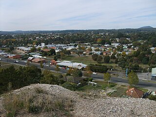
Eastwood is a small triangular inner-southern suburb of Adelaide, South Australia in the City of Burnside.
Yelgun is a small valley in Byron Shire, Northern New South Wales, Australia.

Fitzroy is an inner northern suburb of Adelaide 4 km (2.5 mi) from the Adelaide city centre, in the state of South Australia, within the City of Prospect. It ranks among the most expensive suburban areas in South Australia. It is adjacent to Prospect, Ovingham, Thorngate and, across the Adelaide Park Lands, North Adelaide.

Leschenault is an outer suburb of Bunbury, Western Australia 16 km to the north-east. Its local government area is the Shire of Harvey. Leschenault is generally considered to be a higher socioeconomic area, with higher than average real estate prices.

The City of Mandurah is a local government area of Western Australia, covering both Mandurah proper and an additional area reaching down as far south as Lake Clifton. The city has a total area of approximately 174 square kilometres (67 sq mi).

Sir Donald Bradman Drive is a major arterial road that travels east–west through the western suburbs of Adelaide, South Australia. It is the main route from the Adelaide city centre to the Adelaide Airport.
Mount Clarence is an inner suburb of Albany, Western Australia, between the Albany city centre and Middleton Beach. Its local government area is the City of Albany, and over three-quarters of its land area is either parkland or forest, including Albany's Heritage Park. Mount Clarence was gazetted as a suburb in 1979.
Canadian is a suburb east of the regional city of Ballarat, Victoria, Australia on the rural-urban fringe. At the 2021 census, Canadian had a population of 4,098.
Orana is a north-western suburb of Albany in southern Western Australia, northwest of Albany's central business district. Its local government area is the City of Albany.

Newington is a suburb south west of Ballarat, Victoria, Australia. The population at the 2021 census was 1,844.
Worongary is a suburb in the City of Gold Coast, Queensland, Australia. In the 2016 census, Worongary had a population of 5,613 people.

Romaine is a suburb of the City of Burnie in north-west Tasmania, Australia.
Gong Gong is a locality on the Eastern rural fringe of the City of Ballarat municipality in Victoria, Australia. At the 2021 census, Gong Gong did not have a population high enough to be recorded. The suburb is mostly state forest and contains two reservoirs, Gong Gong and Kirks, that supply Ballarat with potable water. The smaller of the two reservoirs is surrounded by parkland which contains a small ornamental garden.
