The City of Stirling is a local government area in the northern suburbs of the Western Australian capital city of Perth about 10 kilometres (6 mi) north of Perth's central business district. The City covers an area of 105.2 square kilometres (40.6 sq mi) and has a population of over 223,000, making it the largest local government area by population in Western Australia.
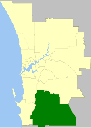
The Shire of Serpentine-Jarrahdale is a local government area in the outer southeastern metropolitan area of Perth, the capital of Western Australia, and has an area of 905 square kilometres (349 sq mi) and a population of almost 27,000 as at the 2016 Census. The Shire's seat of government is the town of Mundijong.

The City of Swan is a local government area of Western Australia. It is in the eastern metropolitan region of Perth and includes the Swan Valley and 42 suburbs. It is centred approximately 20 km north-east of the Perth central business district. The City covers an area of 1,042 km² and had an estimated population of 155,653 in 2020.

Brighton Le Sands, is a suburb in southern Sydney, in the state of New South Wales, Australia. Brighton Le Sands is located 13 kilometres south of the Sydney central business district, on the western shore of Botany Bay. Brighton Le Sands is in the local government area of the Bayside Council and is part of the St George area.

Capel is a town in the South West region of Western Australia, located 212 kilometres (132 mi) south of Perth and midway between Bunbury and Busselton. The town is located on the Capel River and is approximately 19 metres (62 ft) above sea level.

Eneabba is a town on the Brand Highway 278 kilometres (173 mi) north of Perth, Western Australia.

Cataby is a small settlement approximately 170 kilometres (110 mi) north of Perth, Western Australia on the Brand Highway. The area was once called West Dandaragan, with the town of Dandaragan located 17 km to the east.

Glen Osmond is a suburb of Adelaide, South Australia in the City of Burnside which is in the foothills of the Adelaide Hills. It is well known for the road intersection on the western side of the suburb, where the South Eastern Freeway from the Adelaide Hills and the main route from Melbourne splits into National Route A17 Portrush Road, Glen Osmond Road, Adelaide and state route A3 Cross Road west towards the coast and southern suburbs.
Lake Cathie is a town in New South Wales, Australia about 15 minutes drive south of Port Macquarie. At the 2021 census, it had a population of 4,296.

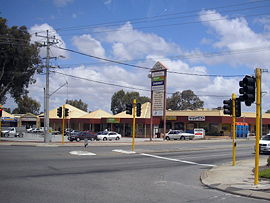
San Remo is an inner northern coastal suburb of Mandurah.
Cooljarloo, also known as Cooljarloo Well, is a location in Western Australia. It is located at 30°39'S 115°22'E, around 170 kilometres north of Perth, and about ten kilometres north of Cataby. It is mostly known as the location of a major mineral sands deposit mined by the Tiwest Joint Venture.

The City of Mandurah is a local government area of Western Australia, covering both Mandurah proper and an additional area reaching down as far south as Lake Clifton. The city has a total area of approximately 174 square kilometres (67 sq mi).

Darbalara is a rural community on the east bank of the junction of the Murrumbidgee River and Tumut River in the Riverina. It is situated by road, about 25 kilometres north east of Gundagai and 25 kilometres south of Coolac.

Aldinga Beach is an outer southern suburb of Adelaide, South Australia. It lies within the City of Onkaparinga and has the postcode 5173. At the 2016 census, Aldinga Beach had a population of 10,557. It lies about a kilometre west of the smaller suburb of Aldinga. The beach is a well-known spot for surfing, swimming, scuba diving, and snorkelling during the summer months. It overlooks an aquatic reserve which has been created to safeguard a unique reef formation.
Dorset Vale is a rural locality near Adelaide, South Australia. It straddles three local government areas adjacent to the Onkaparinga River, being within the Adelaide Hills, Mount Barker and the Onkaparinga council areas. The precise boundaries were set in April 1994 and extended in November 2003 for the long-established name. The first post office in the area was given the English name Dorset Vale circa 1850, but it was locally known as "Scotts Bottom" as it was downstream from Scott Creek. Scotts Bottom School opened in 1930, its name was changed to Dorset Vale in 1937 and it closed in 1944.

Benaraby is a rural town and locality in the Gladstone Region, Queensland, Australia.

Beverley is a western suburb of Adelaide, South Australia. It is located in the City of Charles Sturt.

Allendale North is a locality in the Australian state of South Australia about 4 km (2.5 mi) north of the town of Kapunda.
White Sands is a satellite locality of Murray Bridge in South Australia on the west bank of the Murray River adjacent to Riverglen and overlooking the east bank locality of Monteith. The locality was named after the White Sands Ski Resort, a water skiing and wakeboarding facility, in March 2000.

Vittoria is a suburb of the city of Bunbury comprising the Bunbury port. The suburb is located in the local government area of the City of Bunbury.