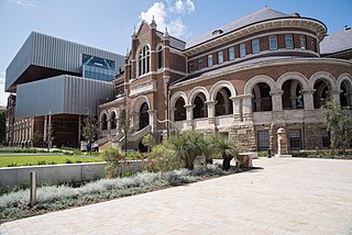
Perth is the capital and largest city of the Australian state of Western Australia. It is the fourth most populous city in Australia and Oceania, with a population of 2.1 million living in Greater Perth in 2020. Perth is part of the South West Land Division of Western Australia, with most of the metropolitan area on the Swan Coastal Plain between the Indian Ocean and the Darling Scarp. The city has expanded outward from the original British settlements on the Swan River, upon which the city's central business district and port of Fremantle are situated. Perth is located on the traditional lands of the Whadjuk Noongar people, where Aboriginal Australians have lived for at least 45,000 years.

The City of Cockburn is a local government area in the southern suburbs of the Western Australian capital city of Perth about 8 kilometres (5 mi) south of Fremantle and about 24 kilometres (15 mi) south of Perth's central business district. The City covers an area of 167.5 square kilometres (64.7 sq mi) and had a population of over 104,000 as at the 2016 Census.

The City of Kwinana is a local government area of Western Australia. It covers an area of approximately 118 square kilometres in metropolitan Perth, and lies about 38 km south of Perth central business district, via the Kwinana Freeway. Kwinana maintains 287 km of roads and had a population of almost 39,000 as at the 2016 Census.

The Shire of Serpentine-Jarrahdale is a local government area in the outer southeastern metropolitan area of Perth, the capital of Western Australia, and has an area of 905 square kilometres (349 sq mi) and a population of almost 27,000 as at the 2016 Census. The Shire's seat of government is the town of Mundijong.

Byford is a suburb on the south-eastern edge of Perth, Western Australia, and has its origins in a township that was gazetted under the name "Beenup" in 1906. "Beenup", a corruption of the Aboriginal name associated with nearby Beenyup Brook, was the spelling that had been applied to a railway siding there. The uncorrupted form, "Bienyup" received mention in surveyor Robert Austin's account of an expedition through the area in 1848. In 1920, the name of the township was changed to Byford.

Serpentine is a town located 55 kilometres (34 mi) south-southeast of Perth, the capital of Western Australia, and 7 km south of Mundijong.
Hillman is an outer southern suburb of Perth, the capital city of Western Australia, located within the City of Rockingham. It is principally a suburb of residential dwellings, and contains Hillman Primary School.

Munster is a suburb of Perth, Western Australia, located within the City of Cockburn.

Cooloongup is an outer southern suburb of Perth, Western Australia, the capital city of Western Australia, located within the City of Rockingham. It consists mainly of residential dwellings.

Port Kennedy is an outer southern suburb of Perth, the capital city of Western Australia, located within the City of Rockingham.

Secret Harbour is an outer southern suburb of Perth, the capital city of Western Australia, located within the City of Rockingham on the Indian Ocean coast at Comet Bay. Despite its name, Secret Harbour does not have a harbour. The name results from a failed marina development and was approved in 1984.

Shoalwater is an outer southern suburb of Perth, the capital city of Western Australia, located within the City of Rockingham.

Singleton is an outer southern suburb of Perth, the capital city of Western Australia, located within the City of Rockingham. It is the southernmost suburb of the Perth Metropolitan Area and is actually closer to the regional city Mandurah than either Perth CBD or Rockingham. The area is under a development near the school, Singleton Primary, and near the main oval, Laurie Stanford Reserve. There is a petrol service station, a small shopping centre, and a school.

Waikiki is an outer southern suburb of Perth, the capital city of Western Australia. It adjoins and is closely associated with Safety Bay in the City of Rockingham. A prime landmark is the Waikiki Village shopping centre on Read Street, the main road linking Rockingham with Warnbro and Port Kennedy.
Coodanup is a south-eastern suburb of Mandurah, Western Australia. Its local government area is the City of Mandurah.
Stake Hill is a northeastern rural residential suburb of Mandurah, Western Australia. Its local government area is the Shire of Murray. At the 2011 census, Stake Hill had a population of 494.

The City of Rockingham is a council and local government area, comprising the south coastal suburbs of the Western Australian capital city of Perth.
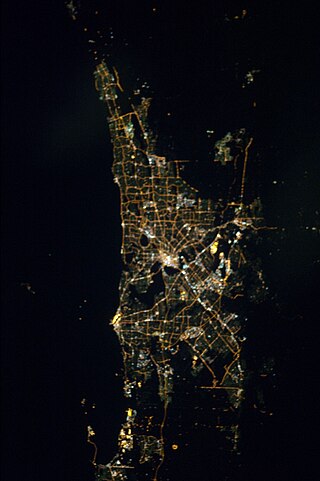
The Perth metropolitan region or the Perth metropolitan area is the administrative area and geographical extent of the Western Australian capital city of Perth and its conurbation.

Cardup is an outer suburb of the Western Australian capital city of Perth, located in the Shire of Serpentine-Jarrahdale to the north of the town Mundijong. In the 2011 census, it had a population of 972 people.

Mardella is an outer suburb of Perth, Western Australia, lying approximately 41 kilometres (25 mi) south-southeast of the central business district. It is located within the Shire of Serpentine-Jarrahdale, and at the 2011 census had a population of 303 people. Although falling within the Perth metropolitan area, Mardella is mostly rural in nature, with a significant proportion of the population engaged in farming.

