The City of Belmont is a local government area in the inner eastern suburbs of the Western Australian capital city of Perth, located about 8 kilometres (5 mi) east of Perth's central business district on the south bank of the Swan River. The City covers an area of 39.8 square kilometres (15.4 sq mi), maintains 225 km of roads and had a population of almost 40,000 as at the 2016 Census. The City of Belmont is a member of the Eastern Metropolitan Regional Council

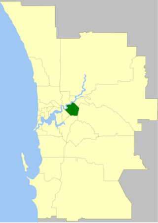
The City of Cockburn is a local government area in the southern suburbs of the Western Australian capital city of Perth about 8 kilometres (5 mi) south of Fremantle and about 24 kilometres (15 mi) south of Perth's central business district. The City covers an area of 167.5 square kilometres (64.7 sq mi) and had a population of over 104,000 as at the 2016 Census.

The City of Kwinana is a local government area of Western Australia. It covers an area of approximately 118 square kilometres in metropolitan Perth, and lies about 38 km south of Perth central business district, via the Kwinana Freeway. Kwinana maintains 287 km of roads and had a population of almost 39,000 as at the 2016 Census.

The City of Vincent is a local government area of Western Australia. It covers an area of approximately 10.4 square kilometres (4.0 sq mi) in metropolitan Perth, the capital of Western Australia, and lies about 3 km from the Perth CBD. The City of Vincent maintains 139 km of roads and 104 ha of parks and gardens. It had a population of over 33,000 at the 2016 Census.

Mundijong is an outer suburb of the Western Australian capital city of Perth.
Hillman is an outer southern suburb of Perth, the capital city of Western Australia, located within the City of Rockingham. It is principally a suburb of residential dwellings, and contains Hillman Primary School.

Warnbro is a southern outer suburb of Perth, the capital of Western Australia, located on Warnbro Sound within the City of Rockingham. It adjoins Port Kennedy which combines residential with retail and light-industrial land use. The suburb, which is named after Warnbro Sound, was gazetted on 5 April 1974.
Wattleup is a southern suburb of Perth, Western Australia, located within the City of Cockburn. In the mid 1990's to the early 2000's, planning was undertaken to redevelop the suburb as part of the Hope Valley-Wattleup Redevelopment Project, also known as "Latitude 32". This was to involve the acquisition and demolition of the townsite, and its rezoning and redevelopment for industrial use. The townsite of Wattleup was located at the western end of the suburb, at the intersection of Wattleup Road and Rockingham Road. Wattleup had many market gardens in the past. They provided agricultural produce for the town of Fremantle.

Cooloongup is an outer southern suburb of Perth, Western Australia, the capital city of Western Australia, located within the City of Rockingham. It consists mainly of residential dwellings.

East Rockingham is an industrial suburb within the Kwinana Industrial Area, part of Perth, and located within the City of Rockingham.
Karnup is an outer southern suburb of Perth, the capital city of Western Australia, located within the City of Rockingham. It is named after the Karnup townsite, which was declared in 1924 and which, in turn, took its name from an Indigenous name of unknown meaning.

Peron is an outer southern suburb of Perth, the capital city of Western Australia, and is located within the City of Rockingham.

Port Kennedy is an outer southern suburb of Perth, the capital city of Western Australia, located within the City of Rockingham.

Safety Bay is an outer southern suburb of Perth, the capital city of Western Australia, located on the coast within the City of Rockingham.

Secret Harbour is an outer southern suburb of Perth, the capital city of Western Australia, located within the City of Rockingham on the Indian Ocean coast at Comet Bay. Despite its name, Secret Harbour does not have a harbour. The name results from a failed marina development and was approved in 1984.

Shoalwater is an outer southern suburb of Perth, the capital city of Western Australia, located within the City of Rockingham.

Singleton is an outer southern suburb of Perth, the capital city of Western Australia, located within the City of Rockingham. It is the southernmost suburb of the Perth Metropolitan Area and is actually closer to the regional city Mandurah than either Perth CBD or Rockingham. The area is under a development near the school, Singleton Primary, and near the main oval, Laurie Stanford Reserve. There is a petrol service station, a small shopping centre, and a school.

The City of Mandurah is a local government area of Western Australia, covering both Mandurah proper and an additional area reaching down as far south as Lake Clifton. The city has a total area of approximately 174 square kilometres (67 sq mi).

The City of Rockingham is a council and local government area, comprising the south coastal suburbs of the Western Australian capital city of Perth.

Rockingham is a suburb of Perth, Western Australia, located 47 km south-south-west of the city centre. It acts as the primary centre for the City of Rockingham. It has a beachside location at Mangles Bay, the southern extremity of Cockburn Sound. To its north stretches the maritime and resource-industry installations of Kwinana and Henderson. Offshore to the north-west is Australia's largest naval fleet and submarine base, Garden Island, connected to the mainland by an all-weather causeway. To the west and south lies the Shoalwater Islands Marine Park.

