East Rockingham, Western Australia

Last updated

East Rockingham
Perth,  Western Australia
CBH terminal from Kwinana Beach 1.jpg
CBH Grain Terminal, East Rockingham
East Rockingham, Western Australia
Coordinates 32°15′32″S115°46′12″E / 32.259°S 115.770°E / -32.259; 115.770
Population311 (SAL 2021) [1]
Postcode(s) 6168
Area8.8 km2 (3.4 sq mi) [2]
LGA(s) City of Rockingham
State electorate(s) Rockingham
Federal division(s) Brand
Suburbs around East Rockingham:
Kwinana Beach Kwinana Beach
East Rockingham Leda
Rockingham Rockingham Hillman

East Rockingham is an industrial suburb within the Kwinana Industrial Area, part of Perth, and located within the City of Rockingham.

Contents

History

The suburb developed as a rural community in the 1850s when various pioneers took up land and settled in the area along Mandurah Road; however, the community declined following the opening of the port at Rockingham in 1872. [3] The Rockingham Road Board's offices were located in East Rockingham between 1905 and 1929. [4]

The Stephenson-Hepburn Plan for Perth and Fremantle (1955) identified the strategic importance of the locality for industrial development. The suburb today contains various industrial developments, with LandCorp making plans to release more land for industrial purposes. [5] The Water Corporation intends to construct a wastewater treatment facility in East Rockingham. [6]

The suburb was named Challenger for a period between 1992 and 1996. It is home to two caravan parks.

Places of natural and cultural heritage significance

As of 2020, 113 places are heritage-listed in the City of Rockingham, [7] of which seven are on the State Register of Heritage Places, with five of those located in East Rockingham. [8]

Significant places:

Transport

Bus

Related Research Articles

Dianella is a suburb of Perth, Western Australia. It is within the local government area of the City of Stirling.

<span class="mw-page-title-main">Claremont, Western Australia</span> Suburb of Perth, Western Australia

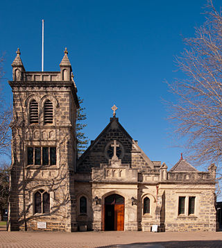
Claremont is a western suburb of Perth, Western Australia, on the north bank of the Swan River.

<span class="mw-page-title-main">Coolbellup, Western Australia</span> Suburb of Perth, Western Australia

Coolbellup is a suburb in Perth, Western Australia, located 15 kilometres (9.3 mi) south of the central business district within the local government area of the City of Cockburn.

<span class="mw-page-title-main">Fremantle railway station</span> Railway station in Fremantle, Western Australia

Fremantle railway station is the terminus of Transperth's Fremantle line in Western Australia.

<span class="mw-page-title-main">Canning Vale, Western Australia</span> Suburb of Perth, Western Australia

Canning Vale is a southern suburb of Perth, 22 km (13.7 mi) from the central business district. Its local government areas are the City of Canning and the City of Gosnells.

<span class="mw-page-title-main">Bentley, Western Australia</span> Suburb of Perth, Western Australia

Bentley is a southern suburb of Perth, the capital city of Western Australia, 8 kilometres (5.0 mi) southeast of Perth's central business district. Its local government areas are the City of Canning and the Town of Victoria Park. Bentley is home to the main campus of Curtin University and Technology Park.

<span class="mw-page-title-main">Kwinana Beach, Western Australia</span> Suburb of Perth, Western Australia

Kwinana Beach is an outer southwestern suburb of Perth, Western Australia, located within the City of Kwinana. It is one of the traditional industrial suburbs in the Perth metropolitan region.

<span class="mw-page-title-main">Leda, Western Australia</span> Suburb of Perth, Western Australia

Leda is a southern suburb of Perth, Western Australia within the City of Kwinana. Leda is one of the five main suburbs of Kwinana.

<span class="mw-page-title-main">Naval Base, Western Australia</span> Suburb of Perth, Western Australia

Naval Base is an coastal southwestern suburb of Perth, Western Australia, located within the City of Kwinana. It is a traditional industrial suburb in the Perth metropolitan region and contains a significant amount of heavy industry. It is named after the proposed and partially built Henderson Naval Base.

<span class="mw-page-title-main">Orelia, Western Australia</span> Suburb of Perth, Western Australia

Orelia is a southern suburb of Perth, Western Australia, located within the City of Kwinana.

<span class="mw-page-title-main">Postans, Western Australia</span> Suburb of Perth Western Australia, Western Australia

Postans is an unpopulated suburb of Perth, Western Australia, located within the City of Kwinana.

<span class="mw-page-title-main">Henderson, Western Australia</span> Suburb of Perth, Western Australia

Henderson is a suburb of Perth, Western Australia, located within the City of Cockburn.

<span class="mw-page-title-main">Munster, Western Australia</span> Suburb of Perth, Western Australia

Munster is a suburb of Perth, Western Australia, located within the City of Cockburn.

Wattleup is a southern suburb of Perth, Western Australia, located within the City of Cockburn. In the mid 1990's to the early 2000's, planning was undertaken to redevelop the suburb as part of the Hope Valley-Wattleup Redevelopment Project, also known as "Latitude 32". This was to involve the acquisition and demolition of the townsite, and its rezoning and redevelopment for industrial use. The townsite of Wattleup was located at the western end of the suburb, at the intersection of Wattleup Road and Rockingham Road. Wattleup had many market gardens in the past. They provided agricultural produce for the town of Fremantle.

<span class="mw-page-title-main">Peron, Western Australia</span> Suburb of City of Rockingham, Western Australia

Peron is an outer southern suburb of Perth, the capital city of Western Australia, and is located within the City of Rockingham.

<span class="mw-page-title-main">Rockingham railway station, Perth</span> Railway station in Perth, Western Australia

Rockingham railway station is a railway station in Rockingham, a suburb of Perth, Western Australia. It is on the Mandurah railway line, which is part of the Transperth commuter rail network. It has two side platforms, linked by a pedestrian overpass accessed by stairs, a lift, and escalators. Services run every 10 minutes during peak, and every 15 minutes between peak. The journey to Perth railway station is 43.2 kilometres (26.8 mi), and takes 34 minutes. The journey to Mandurah railway station is 27.6 kilometres (17.1 mi), and takes 17 minutes. The station has a bus interchange with twelve bus stands, and 14 regular bus routes.

<span class="mw-page-title-main">Belmont, Western Australia</span> Suburb of Perth, Western Australia

Belmont is a suburb of Perth, the capital city of Western Australia, and is located 7 kilometres (4 mi) east of Perth's central business district (CBD) on the southern bank of the Swan River. Its local government area is the City of Belmont.

<span class="mw-page-title-main">East Fremantle, Western Australia</span> Suburb of Perth, Western Australia

East Fremantle is a suburb of Perth, Western Australia, located 13 kilometres (8.1 mi) south-west of the central business district. The suburb is mainly residential, and is coterminous with the Town of East Fremantle local government area.

<span class="mw-page-title-main">Bell Cottage ruin</span> Ruined cottage in East Rockingham, Western Australia

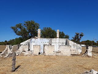
The Bell Cottage ruin is a State Register of Heritage Places-listed ruined Victorian Georgian style cottage in East Rockingham, Western Australia. The ruin is on one of the earliest land grants in the Rockingham area and is one of the oldest structures in the area. It is associated with the Bell family, especially James and Jane Bell, early pioneers in the region. Jane Bell gained public attention in 1840 after the death of her child, conceived after being raped; she was incarcerated for two years on Rottnest Island. In 1876 James Bell was an eyewitness to the Fenian escape from Fremantle Gaol and raised the alarm.

<span class="mw-page-title-main">Chesterfield Inn (Western Australia)</span> Inn in East Rockingham, Western Australia

The Chesterfield Inn and its stables are State Register of Heritage Places-listed buildings in East Rockingham, Western Australia. The Inn was built in 1855 in the vernacular Queen Anne Revival style and is the oldest commercial building in its area.

References

  1. Australian Bureau of Statistics (28 June 2022). "East Rockingham (suburb and locality)". Australian Census 2021 QuickStats. Retrieved 28 June 2022.  OOjs UI icon edit-ltr-progressive.svg
  2. Australian Bureau of Statistics (27 June 2017). "2016 Community Profiles: East Rockingham (State Suburb)". 2016 Census of Population and Housing. Retrieved 26 November 2021. OOjs UI icon edit-ltr-progressive.svg
  3. Taggart, Nora. Rockingham Looks Back. Rockingham District Historical Society (Inc.), 1984
  4. Draper, Richard. Rockingham - The Vision Unfolds. City of Rockingham, 1997
  5. "Rockingham Industry Zone". Archived from the original on 9 March 2011. Retrieved 11 April 2011.
  6. East Rockingham Wastewater Treatment Plant Archived 3 March 2011 at the Wayback Machine
  7. "City of Rockingham Heritage Places". inherit.stateheritage.wa.gov.au. Heritage Council of Western Australia. Retrieved 8 February 2020.
  8. "City of Rockingham State Register of Heritage Places". inherit.stateheritage.wa.gov.au. Heritage Council of Western Australia. Retrieved 8 February 2020.
  9. "Route 548". Bus Timetable 126 (PDF). Transperth. 17 August 2022 [effective from 10 October 2022].
  10. "Route 549". Bus Timetable 125 (PDF). Transperth. 17 August 2022 [effective from 10 October 2022].