
Mandurah is a coastal city in the Australian state of Western Australia, situated approximately 72 kilometres (45 mi) south of the state capital, Perth. It is the state's second most populous city, with a population of 107,641 as of the 2021 census.

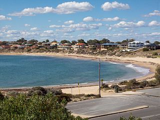
Safety Bay is an outer southern suburb of Perth, the capital city of Western Australia, located on the coast within the City of Rockingham.
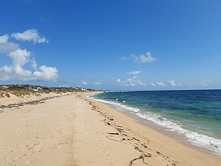
Bouvard is the second southernmost suburb of Mandurah, Western Australia, and is 97 kilometres (60 mi) south of the state capital, Perth. Its local government area is the City of Mandurah.
Falcon is a southern suburb of Mandurah, located southwest of Mandurah's central area and with frontage to the Indian Ocean. The suburb was named after Falcon Bay. Falcon was approved as a suburb name on 13 November 1967 and gazetted on 8 March 1968. Many of the streets in the adjoining estate were named after yachts; "Falcon" itself was the name of a yacht, the crew of which won a silver medal in the 12m² Sharpie yacht races at the 1956 Melbourne Olympics.

Halls Head is a coastal suburb (locality) of Mandurah, immediately west of Mandurah's central area. It is largely residential and contains several canal estates developed since the 1980s.
Meadow Springs is a suburb of Mandurah, immediately northeast of Mandurah's central area. Alongside some of Mandurah's most recent land estates, it contains a large golf course, Catholic primary school, Anglican co-educational school, and a war veterans' estate. There are many parks and walking trails near the lake. The upcoming train station will provide convenient public transport, eliminating the need to drive into Mandurah to catch a train.

Wannanup is a residential suburb in Western Australia, located 12 kilometres (7 mi) southwest of Mandurah and 87 kilometres (54 mi) south-southwest of the state capital, Perth. It is surrounded on three sides by water – the Indian Ocean to the west, the Harvey Estuary to the east and the Dawesville Channel to the south – and is home to the Port Bouvard development. It is one of four suburbs which lie on an island created by the building of the Dawesville Channel.
Stake Hill is a northeastern rural residential suburb of Mandurah, Western Australia. Its local government area is the Shire of Murray. At the 2011 census, Stake Hill had a population of 494.

Mandurah Station is the terminus of the Mandurah railway line and a bus station on the Transperth network, serving the satellite city of Mandurah, Western Australia.
Binningup is a town on the coast of the South West region of Western Australia between Mandurah and Bunbury. At the 2016 census, Binningup had a population of 1,227.

Lake Clifton is a small town located on the east side of the lake of the same name in the Peel region of Western Australia just off the Old Coast Road, between Mandurah and Bunbury at the north end of the Yalgorup National Park. At the 2016 census, Lake Clifton had a population of 683.

Preston Beach is a small town located in the Peel region of Western Australia just off the Forrest Highway, between Mandurah and Bunbury in the Yalgorup National Park.

The City of Mandurah is a local government area of Western Australia, covering both Mandurah proper and an additional area reaching down as far south as Lake Clifton. The city has a total area of approximately 174 square kilometres (67 sq mi).

Herron is a small suburb located in the Peel region of Western Australia just off the Old Coast Road, between Mandurah and Bunbury just beyond Mandurah's urban area. It is on a narrow strip between Lake Clifton and Yalgorup National Park to the west, and Harvey Estuary to the east.

The City of Rockingham is a council and local government area, comprising the south coastal suburbs of the Western Australian capital city of Perth.

Madora Bay is a suburb of the City of Mandurah.

Forrest Highway is a 95-kilometre-long (59 mi) highway in Western Australia's Peel and South West regions, extending Perth's Kwinana Freeway from east of Mandurah down to Bunbury. Old Coast Road was the original Mandurah–Bunbury route, dating back to the 1840s. Part of that road, and the Australind Bypass around Australind and Eaton, were subsumed by Forrest Highway. The highway begins at Kwinana Freeway's southern terminus in Ravenswood, continues around the Peel Inlet to Lake Clifton, and heads south to finish at Bunbury's Eelup Roundabout. There are a number of at-grade intersections with minor roads in the shires of Murray, Waroona, and Harvey including Greenlands Road and Old Bunbury Road, both of which connect to South Western Highway near Pinjarra.

Furnissdale is a locality near Mandurah, Western Australia, to the south of Pinjarra Road and near the Serpentine River entrance into the Peel Inlet within the Shire of Murray. Its postcode is 6209. At the 2011 census, Furnissdale had a population of 1,027.

Nambeelup is a small town and dormitory suburb of the city of Mandurah in the Peel Region of Western Australia.

Rockingham is a suburb of Perth, Western Australia, located 47 km south-south-west of the city centre. It acts as the primary centre for the City of Rockingham. It has a beachside location at Mangles Bay, the southern extremity of Cockburn Sound. To its north stretches the maritime and resource-industry installations of Kwinana and Henderson. Offshore to the north-west is Australia's largest naval fleet and submarine base, Garden Island, connected to the mainland by an all-weather causeway. To the west and south lies the Shoalwater Islands Marine Park.

