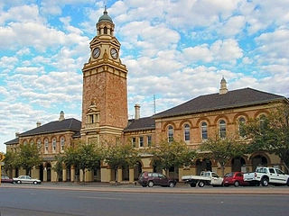
Kalgoorlie is a city in the Goldfields–Esperance region of Western Australia, located 595 km (370 mi) east-northeast of Perth at the end of the Great Eastern Highway. It is sometimes referred to as Kalgoorlie–Boulder, as the surrounding urban area includes the historic townsite of Boulder and the local government area is the City of Kalgoorlie–Boulder.

The Bibbulmun Track is a long-distance walk trail in Western Australia. It runs from Kalamunda in the east of Perth to Albany, and is 1,003.1 kilometres (623.3 mi) long.

Mount Keira is a suburb and mountain in the Illawarra region of New South Wales, Australia.

Norseman is a town located in the Goldfields-Esperance region of Western Australia along the Coolgardie-Esperance Highway, 726 kilometres (451 mi) east of Perth and 278 metres (912 ft) above sea level. It is also the starting point of the Eyre Highway, and the last major town in Western Australia before the South Australian border 720 kilometres (447 mi) to the east. At the 2021 census, Norseman had a population of 562, of which 17% were Australian Aboriginal.

Leonora is a town in the Goldfields-Esperance region of Western Australia, located 833 kilometres (518 mi) northeast of the state capital, Perth, and 237 kilometres (147 mi) north of the city of Kalgoorlie.

Mount Magnet is a town in the Mid West region of Western Australia. It is one of the region's original gold mining towns, and the longest surviving gold mining settlement in the state. The prominent hill that is adjacent to the current townsite was called West Mount Magnet in 1854 by explorer Robert Austin, having named a smaller hill 64 km away, East Mount Magnet. Both hills had an extremely high iron content which affected the readings of his compass. West Mount Magnet had its Aboriginal name reinstated by the Surveyor General in 1972, "Warramboo," meaning campfire camping place. The magnetic variation at Mount Magnet is zero: magnetic north equals true north.
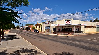
Morawa is a town in the Mid West region of Western Australia. It is located within the Shire of Morawa, approximately 370 kilometres (230 mi) north of the state capital Perth, on the railway line between Wongan Hills and Mullewa.

Mount Barker is a town on Albany Highway and the administrative centre of the Shire of Plantagenet in the Great Southern region of Western Australia. At the 2021 census, Mount Barker had a population of 2,855.

Arkaroola is the common name for the Arkaroola Wilderness Sanctuary, a wildlife sanctuary situated on 610 square kilometres of freehold and pastoral lease land in South Australia. It is located 700 kilometres north of the Adelaide city centre in the Northern Flinders Ranges, adjacent to the Vulkathunha-Gammon Ranges National Park and the Mawson Plateau. The most common way to get there is by car, but air travel can be chartered from Parafield Airport, Adelaide Airport or Aldinga Airfield. It was used as a location set for the 2002 film The Tracker.

Pemberton is a town in the South West region of Western Australia, named after original settler Pemberton Walcott.

Dwellingup is a town in Western Australia located in a timber and fruitgrowing area in the Darling Range east-south-east of Pinjarra. At the 2011 census, Dwellingup had a population of 383.

Boddington is a town and shire in the Peel region of Western Australia, located 120 kilometres (75 mi) south-east of Perth. The town sits on the road from Pinjarra to Williams on the Hotham River. The population of the town was 1,844 at the 2016 Census.

Gwalia is a former gold-mining town located 233 kilometres (145 mi) north of Kalgoorlie and 828 kilometres (514 mi) east of Perth in Western Australia's Great Victoria Desert. Today, Gwalia is essentially a ghost town, having been largely deserted since the main source of employment, the Sons of Gwalia gold mine, closed in 1963. Just 4 kilometres (2.5 mi) north is the town of Leonora, which remains the hub for the area's mining and pastoral industries.
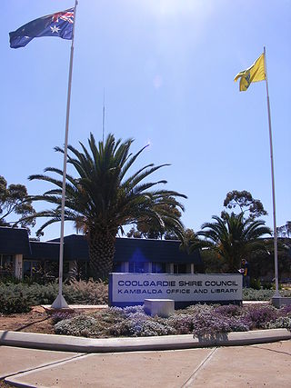
Kambalda is a small mining town about 60 kilometres (37 mi) from the mining city of Kalgoorlie in Western Australia, within the Goldfields. It is split into two townsites 4 kilometres (2.5 mi) apart, Kambalda East and Kambalda West; and is located on the western edge of a giant salt lake, Lake Lefroy. At the last census, Kambalda had a combined population of 2,468.

Mount Dale is a mountain in Western Australia about 25 km (16 mi) east of Armadale in the Shire of Beverley. At 546 m (1,791 ft) high, it is one of the highest points in the Darling Scarp.
Donnelly River Village is a former timber mill town and present-day holiday village in the Shire of Nannup, in the South West region of Western Australia. The Village is located at a point between Nannup, Bridgetown and Manjimup on the Donnelly River, a small, seasonal river at this point, which flows into the Southern Ocean at 34°29′02.4″S115°40′27.8″E. The name also applies to a winery downstream on the Vasse Highway and the township's cottages are sometimes confused with cottages built on the lower reaches of the Donnelly River at 34°28′56″S115°41′00″E.

The Shire of Boddington is a local government area in the Peel region of Western Australia, about 120 kilometres (75 mi) south-east of the state capital, Perth. The Shire covers an area of 1,901 square kilometres (734 sq mi), and its seat of government is the town of Boddington.

The Shire of Mundaring is a local government area in eastern metropolitan Perth, the capital of Western Australia. The Shire covers an area of 645 square kilometres (249 sq mi) and had a population of approximately 38,000 as at the 2016 Census.
Leinster is a town in the northern Goldfields area of Western Australia. It is 4 km (2.5 mi) east of the Goldfields Highway in the Shire of Leonora, and 968 km (601 mi) northeast of the state capital, Perth.
Peak Hill is the name of a goldfield, locality and the site of a gold mining ghost town in the Murchison Region of Western Australia. The gold mine covers 2,162 hectares and consists of four open-cut mines, titled Main, Jubilee, Fiveways and Harmony.

