The 2005 Lake Tanganyika earthquake occurred at on 5 December with a moment magnitude of 6.8 and a maximum Mercalli intensity of X (Extreme). The shock occurred along the East African Rift, an active continental rift zone in East Africa that is characterized by normal faulting, and initiated at a depth of 22 kilometers (14 mi).
The 1999 Hector Mine earthquake occurred in Southern California, United States, on October 16 at 02:46:50 PDT. Its moment magnitude was 7.1 and the earthquake was preceded by 12 foreshocks, the largest of which had a magnitude of 3.8. The event is thought to have been triggered by the 1992 Landers earthquake which occurred seven years earlier. It also deformed nearby faults vertically and horizontally. The earthquake's hypocenter was at a depth of 20 kilometers and its epicenter at 34.603° N 116.265° W.
The 1950 Assam–Tibet earthquake, also known as the Assam earthquake, occurred on 15 August and had a moment magnitude of 8.6. The epicentre was located in the Mishmi Hills in India, known in Chinese as the Qilinggong Mountains (祁灵公山), south of the Kangri Karpo and just east of the Himalayas in the North-East Frontier Agency part of Assam, India. This area, south of the McMahon Line and now known as Arunachal Pradesh, is today disputed between China and India. It is the strongest earthquake ever recorded on land.

The 2002 Hindu Kush earthquakes struck in northern Afghanistan during the month of March. At least 166 people were killed with a very large and intermediate-depth mainshock on March 3. Three weeks later, at least a further two-thousand were killed during a large, but shallow event that had a maximum Mercalli intensity of VII. The M7.4 and M6.1 reverse events were focused in the Hindu Kush mountain range area.
The 2003 Colima earthquake occurred on 21 January with a moment magnitude of 7.6 and a maximum Mercalli intensity of VIII (Severe). The epicenter was located on the Pacific coast in the Mexican state of Colima. The earthquake was felt as far away as Mexico City and in southern parts of the United States.

The 2008 Kyrgyzstan earthquake struck on October 5 at 21:52 local time with a moment magnitude of 6.6, killing 75 people, including 41 children, and injuring 150 people, including 93 children. The center of the earthquake was near the town of Nura, which was destroyed in the quake. The shock destroyed dozens of buildings in the area and destroyed the nearby village of Kura. Minor damage also occurred in nearby Xinjiang Uyghur Autonomous Region. The quake was felt throughout Central Asia. A magnitude 5.7 aftershock in Xinjiang and a magnitude 5.1 aftershock in Kyrgyzstan followed the earthquake. Two more aftershocks above magnitude 5 in Kyrgyzstan and one in Xinjiang struck on October 13, UTC time. Victims were transported in military helicopters to hospitals in Osh.
The 1976 Friuli earthquake, also known in Italy as Terremoto del Friuli, occurred on 6 May 1976, with a moment magnitude of 6.5 and a maximum Mercalli intensity of X (Extreme). The shock occurred in the Friuli region in northeast Italy near the town of Gemona del Friuli. 990 people were killed, up to about 3,000 were injured, and more than 157,000 were left homeless.
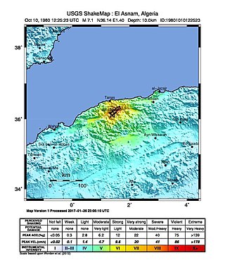
The 1980 El Asnam earthquake occurred on October 10 at with a moment magnitude of 7.1 and a maximum Mercalli intensity of X (Extreme). The shock occurred in the Algerian town of El Asnam. The shocks were felt over 550 km (340 mi) away, with the initial earthquake lasting 35 seconds. It was the largest earthquake in Algeria, and was followed three hours later by a magnitude 6.2 aftershock. The earthquake created about 42 km (26 mi) of surface rupture and had a vertical slip of up to 4.2 m (14 ft). No foreshocks were recorded. The earthquake was found to have occurred very close to the epicenter of the 1954 Chlef earthquake using joint epicenter determination techniques. It occurred at a previously unknown reverse fault.
The 2010 Solomon Islands earthquake occurred with a moment magnitude of 7.1 on January 3 at 22:36:28 (UTC). A tsunami measuring approximately 10 feet affected some parts of the islands, while a maximum run-up height of 23.0 feet was recorded. The earthquake was the largest in a series of quakes to strike the Solomon Islands over the preceding days. The 7.1 mainshock was preceded by a 6.6 magnitude foreshock some 48 minutes previous. As many as 1,000 people were left homeless on the island of Rendova after the earthquake and tsunami destroyed approximately 200 homes.
The 1927 Jericho earthquake was a devastating event that shook Mandatory Palestine and Transjordan on July 11 at . The epicenter of the earthquake was in the northern area of the Dead Sea. The cities of Jerusalem, Jericho, Ramle, Tiberias, and Nablus were heavily damaged and at least 287 were estimated to have been killed.
The 1997 Cariaco earthquake occurred on July 9 at with a moment magnitude of 6.9 and a maximum Mercalli intensity of VIII (Severe). With its epicenter near Cariaco, Venezuela, at least 81 people were killed and over 500 were injured. Disruption of power, telephone, and water services was reported. This earthquake was felt in much of northeastern Venezuela and could also be felt in Trinidad and Tobago. This earthquake was on the strike-slip El Pilar Fault.

The Sagaing Fault is a major fault in Burma, a mainly continental right-lateral transform fault between the Indian Plate and Sunda Plate. It links the divergent boundary in the Andaman Sea with the zone of active continental collision along the Himalayan front. It passes through populated cities of Mandalay, Yamethin, Pyinmana, the capital Naypyidaw, Toungoo and Pegu before dropping off into the Gulf of Martaban, running for a total length of over 1200 kilometers.

The October 2015 Hindu Kush earthquake was a magnitude 7.5 earthquake that struck South Asia on 26 October 2015, at 13:39 AFT with the epicenter 45 km north of Kuran wa Munjan, Afghanistan, at a depth of 212.5 km.
On December 7, 2015, an earthquake measuring 7.2 on the moment magnitude scale struck Tajikistan 105 km (65 mi) west of Murghab at 07:50 UTC at a depth of 26.0 km (16.2 mi). The earthquake was also felt in neighboring Xinjiang in China, India, Afghanistan, Pakistan and Kyrgyzstan.
The 1988 Myanmar–India earthquake, also known as the Indo–Burma earthquake struck the Sagaing Region of Myanmar, about 30 kilometres (19 mi) from the border with India on 6 August at 7:06 am MMT with a moment magnitude (Mw ) of 7.3 or Richter magnitude (ML ) of 7.5. At least five people were killed, more than 30 were injured, and another 30 were missing as a result. Serious damage was reported in India and Bangladesh, while some minor damage occurred in Myanmar. The earthquake was reportedly felt in the Soviet Union.
In 1954, the state of Nevada was struck by a series of earthquakes that began with three magnitude 6.0+ events in July and August that preceded the Mw 7.1–7.3 mainshock and M 6.9 aftershock, both on December 12. All five earthquakes are among the largest in the state, and the largest since the Cedar Mountain earthquake of 1932 and Pleasant Valley event in 1915. The earthquake was felt throughout much of the western United States.
On November 2 of 1946, west Kyrgyzstan was struck by a magnitude 7.5–7.6 earthquake, the largest in the republic since 1911. The earthquake's hypocenter is probably located beneath the Tian Shan Mountains, near the border with Uzbekistan and north of Namangan.

The 1995 Kerinci earthquake struck near Sungai Penuh in Jambi Province on the island of Sumatra, Indonesia. It earthquake occurred at 01:18 WIB local time on October 7. The earthquake measured 6.7 on the moment magnitude scale, and 6.9–7.0 on the surface wave magnitude scale. Between 84 and possibly even 100 people were killed in the earthquake. An extimated 4,000 buildings collapsed or were seriously damaged while a further 5,000 suffered some damage.
The 1985 Kayrakkum earthquake struck Soviet Tajikistan on October 13 at about 22:00 local time. The earthquake measured Mw 5.8 and struck at a depth of 17.1 km (10.6 mi). At least 29 people died, over 80 were injured and another 8,000 were made homeless. Damage totaled $US200 million. Figures of the casualties were not disclosed until the following month.


