The Japan Trench is an oceanic trench part of the Pacific Ring of Fire off northeast Japan. It extends from the Kuril Islands to the northern end of the Izu Islands, and is 8,046 metres (26,398 ft) at its deepest. It links the Kuril–Kamchatka Trench to the north and the Izu–Ogasawara Trench to its south with a length of 800 kilometres (497 mi). This trench is created as the oceanic Pacific plate subducts beneath the continental Okhotsk Plate. The subduction process causes bending of the down going plate, creating a deep trench. Continuing movement on the subduction zone associated with the Japan Trench is one of the main causes of tsunamis and earthquakes in northern Japan, including the megathrust Tōhoku earthquake and resulting tsunami that occurred on 11 March 2011. The rate of subduction associated with the Japan Trench has been recorded at about 7.9–9.2 centimetres (3.1–3.6 in)/yr.

The Australian Plate is a major tectonic plate in the eastern and, largely, southern hemispheres. Originally a part of the ancient continent of Gondwana, Australia remained connected to India and Antarctica until approximately 100 million years ago when India broke away and began moving north. Australia and Antarctica had begun rifting by 96 million years ago and completely separated a while after this, some believing as recently as 45 million years ago, but most accepting presently that this had occurred by 60 million years ago.
Megathrust earthquakes occur at convergent plate boundaries, where one tectonic plate is forced underneath another. The earthquakes are caused by slip along the thrust fault that forms the contact between the two plates. These interplate earthquakes are the planet's most powerful, with moment magnitudes (Mw) that can exceed 9.0. Since 1900, all earthquakes of magnitude 9.0 or greater have been megathrust earthquakes.

The Geology of Puerto Rico "can be divided into three major geologic provinces: The Cordillera Central, the Carbonate, and the Coastal Lowlands." Puerto Rico is composed of Jurassic to Eocene volcanic and plutonic rocks, which are overlain by younger Oligocene to recent carbonates and other sedimentary rocks. Most of the caverns and karst topography on the island occurs in the northern Oligocene to recent carbonates. The oldest rocks are approximately 190 million years old (Jurassic) and are located at Sierra Bermeja in the southwest part of the island. These rocks may represent part of the oceanic crust and are believed to come from the Pacific Ocean realm.

The New Hebrides Plate, sometimes called the Neo-Hebridean Plate, is a minor tectonic plate located in the Pacific Ocean. While most of it is submerged as the sea bottom of the North Fiji Basin, the island country of Vanuatu, with multiple arc volcanoes, is on the western edge of the plate. It is bounded on the south-west by the Australian Plate, which is subducting below it at the New Hebrides Trench. The Vanuatu subduction zone is seismically active, producing many earthquakes of magnitude 7 or higher. To its north is the Pacific Plate, north-east the Balmoral Reef Plate and to its east the Conway Reef Plate.
The 2013 Solomon Islands earthquake struck Temotu Province within Solomon Islands on 6 February with a moment magnitude of 8.0 and a maximum Mercalli intensity of VIII (Severe). The epicentre was close to the Santa Cruz Islands within Temotu Province at the boundaries of the Indo-Australian and Pacific tectonic plates, causing local evacuations, a tsunami of 11 m (36 ft) and killing at least ten people.
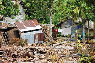
The 1999 Ambrym earthquake occurred on November 26 at with a moment magnitude of 7.4 and a maximum Mercalli intensity of VII. The back arc thrust event occurred within the Vanuatu archipelago, just to the south of the volcanic island of Ambrym. Vanuatu, which was previously known as New Hebrides, is subject to volcanic and earthquake activity because it lies on an active and destructive plate boundary called the New Hebrides Subduction Zone. While the National Geophysical Data Center classified the total damage as moderate, a destructive local tsunami did result in some deaths, with at least five killed and up to 100 injured.
On January 1, 1996, at 4:05 p.m. Central Indonesia Time, an earthquake with an epicenter in the Makassar Strait struck north of Minahasa on the island of Sulawesi, Indonesia. The earthquake measured 7.9 on the moment magnitude scale and was centered off Tolitoli Regency in Central Sulawesi, or 25 km from the Tonggolobibi village. A tsunami of 2–4 m (6.6–13.1 ft) was triggered by this earthquake as a result. At least 350 buildings were badly damaged, nine people died and 63 people were injured.

On 9 December 2016 at 4:38 a.m. local time, the Solomon Islands region was rocked by an Mww 7.8 earthquake, centered 30 km off San Cristobal Island, about 61 km southwest of Kirakira, the capital of Makira-Ulawa Province. Initially registering magnitude 8.0, later downgraded to 7.8, the temblor prompted tsunami warnings that kept countries surrounding the Coral, Tasman and Solomon Sea on high alert, but was later cancelled. A large aftershock of magnitude 6.9 occurred shortly afterwards. This earthquake was largely felt, waking many residents who later ran to high ground for fears of a potential tsunami. The earthquake killed a child and affected some 34,000 people in Makira, South Malaita and Guadalcanal Island where many had lost their homes or had no access to basic needs. Earthquakes are common in this region, with little or no fatalities. This earthquake is tied with three other magnitude 7.8 earthquakes for the second largest earthquake of 2016. On 17 December, the Solomon Islands would be rattled again by a 7.9 magnitude earthquake, this time 54 km east of Taron, Papua New Guinea.

The 1867 Virgin Islands earthquake and tsunami occurred on November 18, at 14.45 in the Anegada Passage about 20 km southwest of Saint Thomas, Danish West Indies. The Ms 7.5 earthquake came just 20 days after the devastating San Narciso Hurricane in the same region. Tsunamis from this earthquake were some of the highest ever recorded in the Lesser Antilles. Wave heights exceeded 10 m (33 ft) in some islands in the Lesser Antilles. The earthquake and tsunami resulted in no more than 50 fatalities, although hundreds of casualties were reported.
The 2009 Vanuatu earthquakes were three earthquakes with magnitudes ranging from 7.4 to 7.8, constituting some of the largest earthquakes in Vanuatu's history.

An earthquake occurred off the coast of the Alaska Peninsula on July 28, 2021, at 10:15 p.m. local time. The large megathrust earthquake had a moment magnitude of 8.2 according to the United States Geological Survey (USGS). A tsunami warning was issued by the National Oceanic and Atmospheric Administration (NOAA) but later cancelled. The mainshock was followed by a number of aftershocks, including three that were of magnitude 5.9, 6.1 and 6.9 respectively.
The 2021 South Sandwich Islands earthquakes were a pair of powerful earthquakes, followed by many strong aftershocks which struck along the South Sandwich Trench in August 2021. The quakes measured 7.5 and 8.1 on the moment magnitude scale, according to the United States Geological Survey. The mainshock is tied with another event in 1929 as the largest earthquake ever recorded in this region, and is tied with the 2021 Kermadec Islands earthquake as the second largest earthquake of 2021.
The 1979 Petatlán earthquake, also known as the IBERO earthquake occurred on March 14 at 05:07 local time in the Mexican state of Guerrero. The earthquake had a surface wave magnitude of Ms 7.6 or moment magnitude of Mw 7.4 and maximum Modified Mercalli intensity of VIII (Severe). The epicenter, onshore, was located 12 km south southeast of Vallecitos de Zaragoza.

The 2002 Port Vila earthquake occurred in the early dawn of January 3, 2002, 04:22 a.m. local time (UTC+11) northwest of Port Vila, the capital of Vanuatu. It had a magnitude of 7.2 and a maximum intensity of X (Extreme) west of the island on the Modified Mercalli intensity scale. There are no exact estimates on the number of injured individuals, but the majority of accounts say there were "several" amounts of injured civilians. the event also caused a minor tsunami of about 0.4−0.8 m just 11 minutes after the quake.
Between the period of May 1990 to April 1991, an earthquake sequence occurred in the Department of San Martín, northern Peru. Three large earthquakes of magnitudes (Mw ) 6.6, 6.5 and 7.1 occurred in the same region, causing extensive damage. At least 189 people were killed in the earthquakes.
The New Hebrides Trench is an oceanic trench which is over 7.1 km (4.4 mi) deep in the Southern Pacific Ocean. It lies to the northeast of New Caledonia and the Loyalty Islands, to the southwest of Vanuatu, east of Australia, and south of Papua New Guinea and the Solomon Islands. The trench was formed as a result of a subduction zone. The Australian Plate is being subducted under the New Hebrides Plate causing volcanism which produced the Vanuatu archipelago.
The 1979 Saint Elias earthquake occurred near noon local time on the 28th of February. It measured Mw 7.4–7.6. Though the maximum recorded Modified Mercalli intensity was VII, damage was minimal and there were no casualties due to the remoteness of the faulting. The epicenter lies near the Alaskan border between America and Canada.
The Vanuatu subduction zone is currently one of the most active subduction zones on earth, producing great earthquakes, with potential for tsunami hazard to all coastlines of the Pacific ocean. There are active volcanoes associated with arc volcanism.