2021 South Sandwich Islands earthquakes

Last updated

2021 South Sandwich Islands earthquakes
UTC  time2021-08-12 18:32:52
 2021-08-12 18:35:17
ISC  event 621237435
  620986442
USGS-ANSS ComCat
  ComCat
Local dateAugust 12, 2021 (2021-08-12)
Local time16:32:52
 16:35:17
Duration4 minutes
Magnitude7.5 Mw
7.8 Ms
 8.1–8.3 Mw [1]
7.8 Ms
Depth47.2 km (29.3 mi)
 22.8 km (14.2 mi) (USGS)
20.0 km (12.4 mi) (GCMT) [1]
10.0 km (6.2 mi) (GEOFON) [2]
Epicenter 58°24′58″S25°19′16″W / 58.416°S 25.321°W / -58.416; -25.321
TypeEither megathrust or Intraplate
Areas affected South Georgia and the South Sandwich Islands
Max. intensity VII (Very strong)
TsunamiUp to 2.46 ft (0.75 m) at South Georgia Island
Aftershocks1,968 Mw4.0+, up to 7.1 Mw [3]
CasualtiesNone

The 2021 South Sandwich Islands earthquakes were a pair of powerful earthquakes, followed by many strong aftershocks which struck along the South Sandwich Trench in August 2021. The quakes measured 7.5 and 8.1 on the moment magnitude scale, according to the United States Geological Survey. [4] [5] The mainshock is tied with another event in 1929 as the largest earthquake ever recorded in the South Atlantic region, [6] and is tied with the 2021 Kermadec Islands earthquake as the second largest earthquake of 2021.

Contents

Tectonic setting

These earthquakes occurred in the Scotia subduction zone, where the South American plate subducts westward beneath the Scotia Plate and South Sandwich microplate (a component of the broader Scotia plate) at a rate of 71 mm/yr. [7] [8]

The 7.5  Mw foreshock was located at a depth of 47 km, placing it within the lower half of the lithosphere of the South American plate, and it is likely to have been caused by compressional forces due to the downward bending of the plate. [7] The mainshock occurred about 3 minutes later at a depth of approximately 56 km and 90 km to the south. Due to seismic interference from the earlier quake, the mechanism, faulting geometry, and rupture details of the mainshock are not yet fully understood. [8] The focal mechanism solution indicates slip occurred on either a steep fault dipping to the northwest or a shallow plane dipping to the southeast within the lithosphere of the subducting plate. [8]

Over the previous century, eight other M 7+ earthquakes, including the M 7.5 foreshock, occurred within 250 km of the August 2021 M 8.1 earthquake. The largest of these previous earthquakes was a M 7.8 earthquake in May 1964. [9] M 7+ earthquakes in the South Sandwich Island region have historically occurred at intermediate depths (broadly defined as 70–300 km depth). However, the largest earthquake in the region was a shallow (10 km deep) M 8.1 earthquake on June 27 1929 that was located approximately 450 km northwest of the epicentre of the August 2021 M 8.1 earthquake along the northern boundary of the two plates. [10] None of these earthquakes are known to have caused fatalities due to their remote location.

Earthquakes

The first earthquake, measured at magnitude 7.5, struck at 16:32 PM local time, but did not cause any damage or casualties. The mainshock, which was the much stronger magnitude 8.1, occurred 3 minutes after the foreshock. A tsunami warning was issued by the Pacific Tsunami Warning Center, but was later cancelled for both events. [11] The Global Centroid Moment Tensor only registered one event measuring Mw 8.3 or Ms 7.5. [1]

Although the two earthquakes were considered intraslab events occurring within the South American Plate, rather than at the boundary of the two plates, the aftershock distribution suggested a rupture of the plate boundary megathrust as well. Aftershocks, some larger than magnitude 6.0, occurred along a 470-km-long segment of the subduction zone, [8] as well as on the outer-rise, and on a transform fault. Seismic signals from the 8.1 mainshock initially went undetected by seismological agencies across the world, as the signals from the foreshock were still propagating and being detected just as it occurred. Several hours after the magnitude 7.5 quake, the U.S. Geologic Survey revealed that a second, much larger, and "complex" event had taken place three minutes after the occurrence of the 7.5. [7] Current understandings of the quake, the strike and dip of the source fault vary between seismological agencies, with data suggesting a megathrust or intraslab quake. [12] A day later it was revealed that it measured 8.1 on the moment magnitude scale, and that the 7.5 earthquake was a foreshock.

Based on the presence of numerous aftershocks on the subduction zone and outer-rise, the earthquake likely ruptured the megathrust all the way to the trench. The aftershock distribution also suggest a large rupture area for the main event. [12]

Characteristics

The event was rather unusual due to its duration of 260 seconds; much longer than usual for its moment magnitude. An initial event measuring 7.5 Mw occurred at a depth of 47 km, lasting 50 seconds. The 7.5 Mw foreshock consisted of two smaller sub-events that initiated along the deeper portion of a thrust fault, but ruptured up-dip. [13]

Shortly afterwards, a 8.16 Mw quake ruptured the shallow subduction zone, with a rupture duration of 180 seconds. The first sub-event ruptured 180 km along the subduction zone interface. Two other sub-events measuring 7.6 Mw and 7.7 Mw occurred 250 km and 300 km south. The 7.6 Mw sub-event involved breaking the shallow subduction zone, displaying characteristics of a tsunami earthquake. The larger and shallower mainshock was a slow-rupturing tsunami earthquake that released 70 percent of the seismic moment. The earthquake released seismic energy in the form of long-period energy, where its period was up to 500 seconds. This resulted in smaller body wave and surface-wave magnitudes, at 6.7–7.1 mb and 7.68 Ms, respectively. The range of depths from 10 to 70 km by various earthquake agencies are due to the interference of seismic data due to the complexity of the event. Deep thrusting also occurred during the mainshock rupture at depths beyond 50 km. [13]

Other events

The South Sandwich Islands mainshock came just 2 weeks after a magnitude 8.2 earthquake, the 7th largest earthquake in US history, struck the Alaskan Peninsula and triggered a small tsunami. [14] On March 4, 2021 an 8.1 magnitude earthquake struck the Kermadec Islands, a sparsely populated territory owned by New Zealand. [15] This temporal clustering is unusual, since earthquakes of magnitude eight or higher occur only about once per year on average. [16] There is no evidence of a causal relationship between these three events, though 2021 has had the most M8+ earthquakes in one year since 2007. [17] [18]

Aftershocks

2021 South Sandwich Islands earthquakes
Map of main shock and aftershocks - M 4.0 or greater (map data)
DateMw MMI Source
2021-08-127.5VI [7]
2021-08-128.1VII [5]
2021-08-126.7I [19]
2021-08-126.1IV [20]
2021-08-126.0IV [21]
2021-08-136.1IV [22]
2021-08-166.9IV [23]
2021-08-176.1IV [24]
2021-08-186.0IV [25]
2021-08-226.6IV [26]
2021-08-227.1IV [27]
2021-10-046.2IV [28]
2021-11-016.0IV [29]
2021-12-036.0III [30]
2021-12-166.0III [31]
2021-12-206.0III [32]
2022-01-256.0III [33]
2022-03-066.0IV [34]

In the 24 hours following the mainshock, 61 aftershocks of M 4.5 or larger were detected, including three aftershocks greater than M 6. These aftershocks spanned a distance of approximately 470 km along the South Sandwich Trench, stretching from the location of the M 7.5 foreshock southward to the triple junction between the South American, South Sandwich, and Antarctic plates. [8]

By August 24, there were approximately 500 aftershocks between magnitudes 4.5 and 5.1, [35] more than 80 aftershocks between magnitudes 5.2 and 6.2, [36] and three aftershocks between magnitudes 6.3 and 6.9. [37] The largest aftershock, measuring 7.1 Mw , occurred on August 22 on a shallow normal fault near the outer rise, within the subducting South American Plate. It had an estimated maximum slip of 2 m (6.6 ft), and a very shallow depth of 6 km. [38]

In total there were 1,968 aftershocks as of 11 December 2022. [3]

Tsunami

A tsunami with a maximum run-up height of around 75 cm (2.46 ft) was measured at King Edward Point, South Georgia Island. Tsunami signals were observed as far away as King Cove, Alaska [15 cm (0.49 ft)] and Rodrigues, Mauritius [23 cm (0.75 ft)]. Waves also hit the Portuguese Azores Islands and eastern Madagascar [20 cm (0.66 ft) and 6 cm (0.20 ft)]. [12] It was also the first tsunami to be recorded in four oceans since the 2004 Indian Ocean tsunami. [39]

See also

Related Research Articles

<span class="mw-page-title-main">2002 Denali earthquake</span> 7.9 magnitude; November 3, 2002

The 2002 Denali earthquake occurred at 22:12:41 UTC November 3 with an epicenter 66 km ESE of Denali National Park, Alaska, United States. This 7.9 Mw earthquake was the largest recorded in the United States in 37 years. The shock was the strongest ever recorded in the interior of Alaska. Due to the remote location, there were no fatalities and only one injury.

<span class="mw-page-title-main">2000 Enggano earthquake</span> Earthquake affecting Indonesia

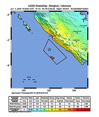
At 23:28 local time on June 4, 2000 southern Sumatra, Indonesia was struck by an earthquake of moment magnitude 7.9 with a maximum Mercalli intensity of VI (Strong). The event occurred off the coast near Enggano Island. There were more than 100 fatalities and up to 2,585 injuries. Over 730 aftershocks shook the area afterwards, one just eleven minutes after the mainshock.

<span class="mw-page-title-main">1952 Severo-Kurilsk earthquake</span> Sixth most powerful on record; in Russia

The 1952 Severo-Kurilsk earthquake struck off the coast of the Kamchatka Peninsula. The 9.0 Mw earthquake triggered a major tsunami that hit Severo-Kurilsk, Kuril Islands, Sakhalin Oblast, Russian SFSR, USSR, on 5 November 1952 at 04:58 local time. This led to the destruction of many settlements in Sakhalin Oblast and Kamchatka Oblast, while the main impact struck the town of Severo-Kurilsk. It was the most powerful earthquake ever recorded in Russia, and the fifth most powerful earthquake ever recorded in the world since modern seismography began in 1900.

The 2000 New Ireland earthquakes occurred off the coast of New Ireland Province, Papua New Guinea on November 16 and 17.

The 1986 Chalfant Valley earthquake struck southern Mono County near Bishop and Chalfant, California at 07:42:28 Pacific Daylight Time on July 21. With a moment magnitude of 6.2 and a maximum Mercalli intensity of VI (Strong), the shock injured two people and caused property damage estimated at $2.7 million in the affected areas. There was a significant foreshock and aftershock sequence that included a few moderate events, and was the last in a series of three earthquakes that affected southern California and the northern Owens Valley in July 1986.

<span class="mw-page-title-main">2018 Hawaii earthquake</span> 6.9-magnitude earthquake in Hawaii

On May 4, 2018, an earthquake with a magnitude of Mw 6.9 struck Hawaii island in the Hawaii archipelago at around 12:33 p.m. local time. The earthquake's epicenter was near the south flank of Kīlauea, which has been the site of seismic and volcanic activity since late April of that year. According to the United States Geological Survey the quake was related to the new lava outbreaks at the volcano, and it resulted in the Hilina Slump moving about two feet. It was the largest earthquake to affect Hawaii since the 1975 earthquake, which affected the same region, killing two people and injuring another 28.

The 2019 Ridgecrest earthquakes of July 4 and 5 occurred north and northeast of the town of Ridgecrest, California located in Kern County and west of Searles Valley. They included three initial main shocks of Mw magnitudes 6.4, 5.4, and 7.1, and many perceptible aftershocks, mainly within the area of the Naval Air Weapons Station China Lake. Eleven months later, a Mw  5.5 aftershock took place to the east of Ridgecrest. The first main shock occurred on Thursday, July 4 at 10:33 a.m. PDT, approximately 18 km (11.2 mi) ENE of Ridgecrest, and 13 km (8.1 mi) WSW of Trona, on a previously unnoticed NE-SW trending fault where it intersects the NW-SE trending Little Lake Fault Zone. This quake was preceded by several smaller earthquakes, and was followed by more than 1,400 detected aftershocks. The M 5.4 and M 7.1 quakes struck on Friday, July 5 at 4:08 a.m. and 8:19 p.m. PDT approximately 10 km (6 miles) to the northwest. The latter, now considered the mainshock, was the most powerful earthquake to occur in the state in 20 years. Subsequent aftershocks extended approximately 50 km (~30 miles) along the Little Lake Fault Zone.

The 2020 Sparta earthquake was a relatively uncommon intraplate earthquake that occurred near the small town of Sparta, North Carolina, on August 9, 2020 at 8:07 am local time. The earthquake had a moment magnitude of 5.1, and a shallow depth of 7.6 kilometers (4.7 mi). Shaking was reported throughout the Southern, Midwestern, and Northeastern United States. It was the strongest earthquake recorded in North Carolina in 104 years, the second-strongest in the state's history, and the largest to strike the East Coast since the 2011 Virginia earthquake.

On January 1, 1996, at 4:05 p.m. Central Indonesia Time, an earthquake with an epicenter in the Makassar Strait struck north of Minahasa on the island of Sulawesi, Indonesia. The earthquake measured 7.9 on the moment magnitude scale and was centered off Tolitoli Regency in Central Sulawesi, or 25 km from the Tonggolobibi village. A tsunami of 2–4 m (6.6–13.1 ft) was triggered by this earthquake as a result. At least 350 buildings were badly damaged, nine people died and 63 people were injured.

<span class="mw-page-title-main">2016 Solomon Islands earthquakes</span> Seismic events

On 9 December 2016 at 4:38 a.m. local time, the Solomon Islands region was rocked by an Mww 7.8 earthquake, centered 30 km off San Cristobal Island, about 61 km southwest of Kirakira, the capital of Makira-Ulawa Province. Initially registering magnitude 8.0, later downgraded to 7.8, the temblor prompted tsunami warnings that kept countries surrounding the Coral, Tasman and Solomon Sea on high alert, but was later cancelled. A large aftershock of magnitude 6.9 occurred shortly afterwards. This earthquake was largely felt, waking many residents who later ran to high ground for fears of a potential tsunami. The earthquake killed a child and affected some 34,000 people in Makira, South Malaita and Guadalcanal Island where many had lost their homes or had no access to basic needs. Earthquakes are common in this region, with little or no fatalities. This earthquake is tied with three other magnitude 7.8 earthquakes for the second largest earthquake of 2016. On 17 December, the Solomon Islands would be rattled again by a 7.9 magnitude earthquake, this time 54 km east of Taron, Papua New Guinea.

The 2018 Fiji earthquakes occurred on August 19, at 00:19:40 UTC and on September 6 15:49 UTC. The epicenters were located close to the Fijian island Lakeba, and around 270 km from the small town of Levuka on Ovalau. The first earthquake registered a magnitude of Mww  8.2, and is the largest earthquake of 2018. It had a focal depth of 600 km, making it the second largest earthquake ever recorded at a depth greater than 300 km; a tie with the 1994 Bolivia earthquake, and behind the 2013 Okhotsk Sea earthquake. The initial earthquake was caused by a normal fault below the South Pacific Ocean. An Mww  7.9 event struck the islands again on September 6 at a depth of 670 km; this earthquake was a mainshock of its own. Both earthquakes may be considered a doublet event.

<span class="mw-page-title-main">2013 Craig, Alaska earthquake</span> Earthquake in Alaska and British Columbia

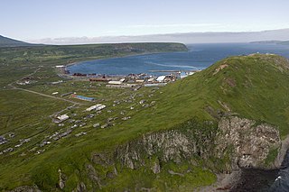
The 2013 Craig, Alaska earthquake struck on January 5, at 12:58 am (UTC–7) near the city of Craig and Hydaburg, on Prince of Wales Island. The Mw 7.5 earthquake came nearly three months after an Mw  7.8 quake struck Haida Gwaii on October 28, in 2012. The quake prompted a regional tsunami warning to British Columbia and Alaska, but it was later cancelled. Due to the remote location of the quake, there were no reports of casualties or damage.

The 2021 Kermadec Islands earthquakes were a series of earthquakes with magnitudes of 8.1 and 7.4 that occurred at 19:28:31 UTC on 4 March 2021. The epicentres were located southeast of Raoul Island in the Kermadec Islands, part of the New Zealand outlying islands. The main magnitude 8.1 earthquake was preceded by a magnitude 7.4 foreshock and followed by a magnitude 6.1 aftershock. A separate, unrelated magnitude 7.3 earthquake occurred off the coast of the North Island of New Zealand, approximately 900 km to the south, several hours before the main quakes. More than a dozen aftershocks exceeded magnitude 6.

The Nemuro-Oki earthquake in scientific literature, occurred on June 17 at 12:55 local time. It struck with an epicenter just off the Nemuro Peninsula in northern Hokkaidō, Japan. It measured 7.8–7.9 on the moment magnitude scale (Mw ), 8.1 on the tsunami magnitude scale (Mt ) and 7.4 on the Japan Meteorological Agency magnitude scale (MJMA ).

The 1995 Menglian earthquake or 1995 Myanmar–China earthquake occurred on 12 July at 05:46:43 local time in the Myanmar–China border region. The earthquake had an epicenter on the Myanmar side of the border, located in the mountainous region of Shan State. It registered 7.3 on the Chinese surface wave magnitude scale (Ms ) and 6.8 on the moment magnitude scale (Mw ). With a maximum Mercalli intensity assigned at VIII, the quake killed eleven people and left another 136 injured. Over 100,000 homes in both countries were destroyed and 42,000 seriously damaged. Some damage to structures were also reported in Chiang Mai and Chiang Rai, Thailand. The low death toll from this earthquake was attributed to an early warning issued prior to it happening. Precursor events including foreshocks and some seismic anomalies led to an evacuation of the area before the mainshock struck. It is thought to be one of the few successfully predicted earthquakes in history.

<span class="mw-page-title-main">2021 Chignik earthquake</span> 7th largest earthquake in the US

An earthquake occurred off the coast of the Alaska Peninsula on July 28, 2021, at 10:15 p.m. local time. The large megathrust earthquake had a moment magnitude of 8.2 according to the United States Geological Survey (USGS). A tsunami warning was issued by the National Oceanic and Atmospheric Administration (NOAA) but later cancelled. The mainshock was followed by a number of aftershocks, including three that were of magnitude 5.9, 6.1 and 6.9 respectively.

The 2021 Loyalty Islands earthquake was a 7.7 magnitude earthquake that struck offshore between Vanuatu and New Caledonia on February 11, 2021 at 00:19 local time. It is the 4th largest earthquake of 2021.

The 2016 Alborian Sea earthquake struck offshore, north northeast of Al Hoceïma, Morocco in the Strait of Gibraltar on January 25 at 04:22:02 UTC, or roughly 05:22:02 West Africa Time. At its strongest in the Alboran Sea, the earthquake measured 6.3–6.4 on the moment magnitude scale (Mw ) at a shallow hypocenter depth of 12 km (7.5 mi). Assigned a maximum Modified Mercalli scale intensity of VI (Strong), the earthquake caused one fatality, injuries to at least 30 persons, and moderate damage in Morocco and Spain.

<span class="mw-page-title-main">2021 Arkalochori earthquake</span> Earthquake in Crete, Greece

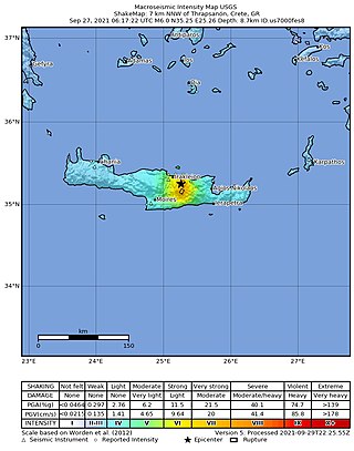
A moment magnitude 6.0 earthquake struck the island of Crete in Greece at a depth of 6 km on 27 September 2021. The epicenter of the earthquake was located southeast of Heraklion. The quake killed one person, injured 36 and damaged over 5,000 old buildings on the island.

The 1979 Saint Elias earthquake occurred near noon local time on the 28th of February. It measured Mw 7.4–7.6. Though the maximum recorded Modified Mercalli intensity was VII, damage was minimal and there were no casualties due to the remoteness of the faulting. The epicenter lies near the Alaskan border between America and Canada.

References

  1. 1 2 3 "Global CMT Catalog". Global Centroid Moment Tensor. Retrieved 10 September 2021.
  2. "GEOFON Program". GFZ. Retrieved 10 September 2021.
  3. 1 2 "USGS earthquake catalog". United States Geological Survey.
  4. "M 7.5 - South Sandwich Islands region". United States Geological Survey . Retrieved 12 August 2021.
  5. 1 2 "M 8.1 - South Sandwich Islands region". United States Geological Survey . Retrieved 12 August 2021.
  6. "M 8.1 - South Sandwich Islands Region". United States Geological Survey. 27 June 1929.
  7. 1 2 3 4 "M 7.5 - South Sandwich Islands region". earthquake.usgs.gov. Retrieved 30 August 2021.
  8. 1 2 3 4 5 "M 8.1 - South Sandwich Islands region". earthquake.usgs.gov. Retrieved 30 August 2021.
  9. "M 7.8 - South Sandwich Islands region". United States Geological Survey. Retrieved 13 August 2021.
  10. "M 8.1 - South Sandwich Islands region (1929)". United States Geological Survey. Retrieved 13 August 2021.
  11. "Earthquake of magnitude 7.5 strikes South Sandwich Islands region". Reuters . 12 August 2021. Retrieved 13 August 2021.
  12. 1 2 3 Hubbard, Judith (7 September 2021). "Mixed earthquake signals in the South Sandwich Islands". Temblor. Earth Observatory of Singapore, Nanyang Technological University: Temblor, Inc. doi:10.32858/temblor.202. S2CID   244092196 . Retrieved 10 September 2021.
  13. 1 2 Jia, Zhe; Zhongwen, Zhan; Kanamori, Hiroo (2022). "The 2021 South Sandwich Island Mw 8.2 Earthquake: A Slow Event Sandwiched Between Regular Ruptures". Geophysical Research Letters. 49 (3). Bibcode:2022GeoRL..4997104J. doi: 10.1029/2021GL097104 . S2CID   244736464.
  14. "M 8.2 - 91 km ESE of Perryville, Alaska". 29 July 2021.
  15. "M 8.1 - Kermadec Islands region". USGS-ANSS. Retrieved 4 March 2021.
  16. "USGS Earthquake Hazards Program: FAQ". Earthquake.usgs.gov. 10 December 2012. Archived from the original on 20 November 2014. Retrieved 24 December 2012.
  17. "Significant Earthquakes - 2007". United States Geological Survey. Retrieved 13 August 2021.
  18. "M8+ in 2007". United States Geological Survey. Retrieved 13 August 2021.
  19. "M 6.7 - South Sandwich Islands region". United States Geological Survey . Retrieved 12 August 2021.
  20. "M 6.1 - South Sandwich Islands region". United States Geological Survey . Retrieved 12 August 2021.
  21. "M 6.0 - South Sandwich Islands region". United States Geological Survey . Retrieved 12 August 2021.
  22. "M 6.1 - South Sandwich Islands region". United States Geological Survey . Retrieved 13 August 2021.
  23. "M 6.9 - South Sandwich Islands region". United States Geological Survey . Retrieved 16 August 2021.
  24. "M 6.1 - South Sandwich Islands region". United States Geological Survey . Retrieved 17 August 2021.
  25. "M 6.0 - South Sandwich Islands region". United States Geological Survey . Retrieved 7 September 2021.
  26. "M 6.6 - South Sandwich Islands region". United States Geological Survey . Retrieved 22 August 2021.
  27. "M 7.1 - South Sandwich Islands region". United States Geological Survey . Retrieved 22 August 2021.
  28. "M 6.2 - South Sandwich Islands region". United States Geological Survey.
  29. "6.0 - South Sandwich Islands region". United States Geological Survey.
  30. "M 6.0 - South Sandwich Islands region". earthquake.usgs.gov. United States Geological Survey.
  31. "M 6.0 - South Sandwich Islands region". earthquake.usgs.gov.
  32. "M 6.0 - South Sandwich Islands region". earthquake.usgs.gov. United States Geological Survey.
  33. "M 6.0 - South Sandwich Islands region". United States Geological Survey. 25 January 2022. Archived from the original on 25 January 2022. Retrieved 25 January 2022.
  34. "M 6.0 - South Sandwich Islands region". earthquake.usgs.gov. Archived from the original on 6 March 2022.
  35. "USGS earthquake catalog". United States Geological Survey . Retrieved 6 November 2021.
  36. "USGS earthquake catalog". United States Geological Survey . Retrieved 6 November 2021.
  37. "USGS earthquake catalog". United States Geological Survey . Retrieved 6 November 2021.
  38. "M 7.1 - South Sandwich Islands region". United States Geological Survey . Retrieved 22 August 2021.
  39. "South Sandwich Islands Tsunami, August 12, 2021". nctr.pmel.noaa.gov. Retrieved 28 September 2021.