
MAX Light Rail is a light rail system in Portland, Oregon, United States. Owned and operated by TriMet, it consists of five lines serving a 94-station, 59.7-mile (96.1 km) network. MAX connects Portland City Center with all six sections of Portland; the communities of Beaverton, Clackamas, Gresham, Hillsboro, and Milwaukie; and Portland International Airport. In 2019, it had an average daily ridership of 120,900 and 38.8 million annually. Due to the COVID-19 pandemic, which impacted public transit use globally, annual ridership plummeted to 14.8 million in 2021. Lines run seven days a week with headways of between 30 minutes off-peak and three minutes during rush hours.

Oregon Route 212 is an Oregon state highway that serves the eastern Portland metro area. It is an east–west route, running between Boring and Clackamas.
Interstate 205 (I-205) is an auxiliary Interstate Highway in the Portland metropolitan area of Oregon and Washington. The north–south freeway serves as a bypass route of I-5 along the east side of Portland, Oregon, and Vancouver, Washington. It intersects several major highways and serves Portland International Airport.

The MAX Yellow Line is a light rail service in Portland, Oregon, United States, operated by TriMet as part of the MAX Light Rail system. It connects North Portland to Portland City Center and Portland State University (PSU) with 17 stops from Expo Center station to PSU South/Southwest 6th and College station. The line travels from Portland Expo Center in the north, south to the Rose Quarter through a 5.8-mile (9.3 km) light rail segment along the median of Interstate Avenue. From the Rose Quarter, it crosses the Willamette River via the Steel Bridge and enters downtown Portland, where it operates as a northbound-only service of the Portland Transit Mall on 6th Avenue. Service runs for approximately 21 hours daily with a headway of 15 minutes during most of the day.

The Northeast 82nd Avenue station is a light rail station on the MAX Blue, Green and Red Lines in Portland, Oregon. It is the 13th stop eastbound on the eastside MAX. It serves the neighborhoods of Rose City Park, Roseway, Madison South, Montavilla and Mount Tabor.

Like transportation in the rest of the United States, the primary mode of local transportation in Portland, Oregon is the automobile. Metro, the metropolitan area's regional government, has a regional master plan in which transit-oriented development plays a major role. This approach, part of the new urbanism, promotes mixed-use and high-density development around light rail stops and transit centers, and the investment of the metropolitan area's share of federal tax dollars into multiple modes of transportation. In the United States, this focus is atypical in an era when automobile use led many areas to neglect their core cities in favor of development along interstate highways, in suburbs, and satellite cities.
Portland is "an international pioneer in transit orientated developments."

Oregon Route 213 is an Oregon state highway that serves the eastern Willamette Valley between Portland and Salem. It is a north–south route. The route is known as the Cascade Highway, though specific segments are generally better known by more localized names.

The MAX Green Line is a light rail service in Portland, Oregon, United States, operated by TriMet as part of the MAX Light Rail system. It is 15 miles (24.1 km) long and serves 30 stations from the PSU South stations to Clackamas Town Center Transit Center, connecting Portland State University (PSU), Portland City Center, Northeast Portland, Southeast Portland, and Clackamas. The Green Line is the only service that shares parts of its route with the four other MAX services, sharing the Portland Transit Mall with the Orange and Yellow lines and the Banfield segment of the Eastside MAX with the Blue and Red lines. Southbound from Gateway/Northeast 99th Avenue Transit Center, it operates the Interstate 205 (I-205) segment through to Clackamas Town Center. Service runs for approximately 211⁄2 hours daily with a headway of 15 minutes during most of the day. It is the third-busiest line in the system, carrying an average of 19,160 riders per day on weekdays in September 2019.
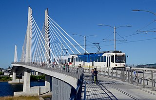
The MAX Orange Line is a light rail service in Portland, Oregon, United States, operated by TriMet as part of the MAX Light Rail system. It connects Portland City Center to Portland State University (PSU), Southeast Portland, Milwaukie, and Oak Grove. The Orange Line starts near Portland Union Station heading southbound within downtown Portland along the Portland Transit Mall on 5th Avenue. From the transit mall, it continues along a 7.3-mile (11.7 km) segment, which runs through the South Waterfront, across the Willamette River into Southeast Portland, then south to Oak Grove, just outside Milwaukie proper in unincorporated Clackamas County. The Orange Line serves 17 stations from Union Station/Northwest 5th & Glisan to Southeast Park Avenue and runs for 201⁄2 hours daily with a minimum headway of 15 minutes during most of the day. The line carried an average of 3,480 daily weekday riders in September 2020.

The Clackamas Town Center Transit Center is a bus transit center and MAX Light Rail station on the MAX Green Line, located in Clackamas County, Oregon, in the southeastern part of the Portland metropolitan area. It is the southern terminus for the I-205 MAX branch.

Ardenwald-Johnson Creek is a neighborhood straddling the border between Portland and Milwaukie, Oregon. It is recognized by both Portland's Office of Neighborhood Involvement as well as Milwaukie's Neighborhoods Program.

The Lents neighborhood in the Southeast section of Portland, Oregon is bordered by SE Powell Blvd. on the north, the Clackamas County line or City of Portland line on the south, SE 82nd Ave. to the west, and roughly SE 112th on the east. The NE corner overlaps with the Powellhurst-Gilbert neighborhood. In addition to Powellhurst-Gilbert on the north and east, Lents also borders Foster-Powell, Mt. Scott-Arleta, and Brentwood-Darlington on the west and Pleasant Valley on the east.
Madison South is a neighborhood in the Northeast section of Portland, Oregon. It is bordered by the Roseway, Sumner, Cully, Parkrose, Montavilla, and Rose City Park neighborhoods, and by the enclave city of Maywood Park. The neighborhood roughly conforms to the boundaries of Interstate 84 to the south, Interstate 205 to the east, NE Sandy Boulevard to the north, and NE 65th Avenue to the west.
Parkrose is a neighborhood in the Northeast section of Portland, Oregon, and is considered part of East Portland. It is bordered by Sumner to the west, the Columbia River to the north, Argay to the east, and Parkrose Heights and the city of Maywood Park to the south. Sandy Boulevard crosses the neighborhood, with a primarily industrial area prevailing to the north and primarily residential area to the south.

The Mt. Scott-Arleta neighborhood of Portland, Oregon is located in the city's southeast quadrant. It is bounded on the north by SE Foster Road, west by SE 60th Avenue, east by SE 82nd Avenue, and south by SE Duke. Mt. Scott-Arleta borders the neighborhoods of Woodstock on the west, Foster-Powell on the north, Lents on the east, and Brentwood-Darlington on the south.

Foster-Powell is a neighborhood in the Southeast section of Portland, Oregon. The triangular neighborhood is bounded by three major transit arteries: Powell Boulevard to the north, Foster Road to the south, and 82nd Avenue to the east.
South Tabor is a neighborhood in southeastern Portland, Oregon in the United States. The neighborhood is bounded by SE Division, Powell, 52nd, and 82nd Avenues. Its neighborhood association is a member of the Southeast Uplift coalition, which serves as its link to Portland's Office of Neighborhood Involvement.
Montavilla is a neighborhood in the Northeast and Southeast sections of Portland, Oregon, United States, and contains an area east of Mount Tabor and west of Interstate 205, from the Banfield to SE Division. It is bordered by North Tabor, Mount Tabor, Madison South, Hazelwood, and Powellhurst-Gilbert.
Burnside Street is a major thoroughfare of Portland, in the U.S. state of Oregon, and one of a few east–west streets that run uninterrupted on both sides of the Willamette River. It serves as the dividing line between North Portland and South Portland. Its namesake bridge, Burnside Bridge, is one of the most heavily traversed in Portland. In Gresham between approximately the east 18300 block to Mt. Hood Hwy, Burnside runs southeast–northwest and is no longer the divide between northeast and southeast on the City of Portland-Multnomah County street grid. Additionally, SE Burnside St becomes NW Burnside Road at SE 202nd/NW Birdsdale Ave, and NE Burnside Rd at N Main Ave in Gresham. Burnside Road's eastern terminus is where it meets Mt. Hood Hwy (US-26), E Powell Blvd (US-26), and SE Powell Valley Road.

The Jade District is an Asian-dominated commercial area and cultural hub radiating outward from Southeast 82nd Avenue and Division Street, in Portland, Oregon, in the United States. It is roughly between Division Street and Powell Boulevard to the north and south, and between SE 75th Avenue and I-205 to the east and west. Part of the Montavilla, Powellhurst-Gilbert, and South Tabor neighborhoods, the district is one of the most diverse census tracts in the state of Oregon.
