Brentwood-Darlington, Portland, Oregon

Last updated
Brentwood-Darlington
Neighborhood
Brentwood-Darlington, Portland, Oregon
Location in Portland
Coordinates: 45°28′07″N122°35′50″W / 45.46863°N 122.59715°W / 45.46863; -122.59715 PDF map
Country United States
State Oregon
City Portland
Government
  Association Brentwood/Darlington Neighborhood Association
  Coalition Southeast Uplift Neighborhood Program
Area
  Total1.75 sq mi (4.53 km2)
Population
 (2010) [1] [2]
  Total12,994
  Density7,400/sq mi (2,900/km2)
Housing
[1]
  No. of households12,846
  Occupancy rate94% occupied
  Owner-occupied3210 households (67%)
  Renting1590 households (33%)
  Avg. household size2.68 persons

Brentwood-Darlington is a neighborhood on the southern edge of Portland, Oregon, bordering SE 45th Avenue to the west, SE Duke Street to the north, and SE 82nd Avenue to the east. The county line separating Multnomah County from Clackamas County forms most of the neighborhood's (and the city's) southern boundary, though small portions of the neighborhood and the city extend into Clackamas County. (Conversely, some areas in the neighborhood in Multnomah County are outside Portland city limits.) Roughly, the southern boundary is SE Harney Drive on the eastern one-fourth, and SE Clatsop Street on the other three-quarters.

Contents

The Brentwood-Darlington Neighborhood Association dates to 1974 when it was founded as the Errol Heights Improvement Association, serving the neighborhoods of Errol Heights, Brentwood, Darlington, Harney Park, Woodmere, and Crystal Springs. [3] In 2013, the Brentwood-Darlington Neighborhood Association held a 'visioning' process to determine future plans for the neighborhood. [4]

The Brentwood-Darlington Community Center, run by a local non-profit agency, Impact NW and provides early childhood and other services to families in the community. Schools in the area include Woodmere Elementary School, Whitman Elementary School, Lane Middle School, ACCESS Middle School, and Community Transition Project School.

The neighborhood is home to several large scale urban gardening projects, including the Brentwood Community Garden, which was improved and expanded in 2010 through a grant from The Home Depot and Fiskars. [5] It is also home to the Portland State University Learning Gardens Laboratory. [6]

Brentwood-Darlington includes Brentwood Park (1951), Errol Heights Natural Area (1966), and Hazeltine Park (2001), which was named after longtime neighborhood resident and leader, Dick Hazeltine. [7]

In 2010, a new, full-service grocery store opened in the neighborhood. [8]

Demographics

As of the 2010 Census Brentwood-Darlington has a population of 12,994. The resents of the area identify as 72.0% White, 10.4% Asian, 3.6% Black, 1.6% American Indian, and 5.4% are mixed race. Of the population 13.9% identify as Hispanic or Latino. [9]

History

SE 82nd and Duke 1958 1958 se-82nd-and-duke -a2010-002-883.jpg
SE 82nd and Duke 1958

Brentwood-Darlington started as single family homesteads in 1882. The streets were divided into a grid pattern with long blocks with many of the roads leading to the nearby town of Milwaukie rather than Portland. The Donation Land Claim Act of 1850 granted settlers to unsurveyed land for promotion of settlement across the Oregon Territory. Settlers of the area took advantage of the land claim act and George Wills, a Baptist preacher and farmer eventually claimed ownership to the majority of the land in the area. [10]

in 1920 the Apostolic Faith International Headquarters formerly the Apostolic Faith Meeting Park was established [11]

World War II brought an influx of people into the area and lead to rapid growth in the community. It was common to see homeowners run small businesses out of their homes during this time. As an unincorporated neighborhood of Portland many homes were inadequately constructed and roads in a state of disarray due to the lack of services in the area. Yearly grass and hazel brush fires along with runaway fires from a local sawmill lead to the first fire department to the area in 1947. [11]

In 1974 Brentwood-Darlington was made an officially designated neighborhood under the name Errol Heights. Brentwood-Darlington received many attempts of annexation into Portland in 1961, 1971, and 1977 but the efforts made failed due to opposition of the residents of the area. Annexation attempts were revived in the 1980s due to concerns of pollution and inadequate water service and the area was successfully annexed into Portland in 1986. The former name of Errol Heights was changed to Brentwood-Darlington in February, 1986. [11] [12]

Parks

Brentwood Park, Fall 2019 Brentwood park 2.jpg
Brentwood Park, Fall 2019

Related Research Articles

<span class="mw-page-title-main">Oregon City, Oregon</span> City in Oregon, United States

Oregon City is the county seat of Clackamas County, Oregon, United States, located on the Willamette River near the southern limits of the Portland metropolitan area. As of the 2020 census, the city population was 37,572. Established in 1829 by the Hudson's Bay Company, in 1844 it became the first U.S. city west of the Rocky Mountains to be incorporated.

<span class="mw-page-title-main">Milwaukie, Oregon</span> City in Oregon, United States

Milwaukie is a city mostly in Clackamas County, Oregon, United States; a very small portion of the city extends into Multnomah County. The population was 21,119 at the 2020 census. Founded in 1847 on the banks of the Willamette River, the city, known as the Dogwood City of the West, was incorporated in 1903 and is the birthplace of the Bing cherry. The city is now a suburb of Portland and also adjoins the unincorporated areas of Clackamas and Oak Grove.

Portland Community College (PCC) is a public community college in Portland, Oregon. It is the largest post-secondary institution in the state and serves residents in the five-county area of Multnomah, Washington, Yamhill, Clackamas, and Columbia counties. As of the 2021–2022 academic year, PCC enrolls more than 50,000 full-time (40%) and part-time (60%) students.

<span class="mw-page-title-main">Portland metropolitan area, Oregon</span> Metropolitan statistical area in the United States

The Portland metropolitan area is a metro area with its core in the U.S. states of Oregon and Washington. It has 5 principal cities the largest being Portland, Oregon. The U.S. Office of Management and Budget (OMB) identifies it as the Portland–Vancouver–Hillsboro, OR–WA Metropolitan Statistical Area, a metropolitan statistical area used by the United States Census Bureau (USCB) and other entities. The OMB defines the area as comprising Clackamas, Columbia, Multnomah, Washington, and Yamhill Counties in Oregon, and Clark and Skamania Counties in Washington. The area had a population of 2,512,859 at the 2020 census, an increase of over 12% since 2010.

<span class="mw-page-title-main">Oregon Route 43</span> Highway in Oregon

Oregon Route 43 is an Oregon state highway that runs between the cities of Oregon City and Portland, mostly along the western flank of the Willamette River. While it is technically known by the Oregon Department of Transportation as the Oswego Highway No. 3, on maps it is referred to by its route number or by the various street names it has been given.

Maplewood is a suburban neighborhood in Southwest Portland, Oregon, United States.

<span class="mw-page-title-main">National Register of Historic Places listings in Oregon</span>

This is a list of properties and historic districts in Oregon that are listed on the National Register of Historic Places. There are listings in all of Oregon's 36 counties.

<span class="mw-page-title-main">Ardenwald-Johnson Creek, Portland, Oregon</span> Unincorporated community in the state of Oregon, United States

Ardenwald-Johnson Creek is a neighborhood straddling the border between Portland and Milwaukie, Oregon. It is recognized by both Portland's Office of Neighborhood Involvement as well as Milwaukie's Neighborhoods Program.

<span class="mw-page-title-main">Lents, Portland, Oregon</span> Neighborhood in Portland, Oregon, United States

The Lents neighborhood in the Southeast section of Portland, Oregon is bordered by SE Powell Blvd. on the north, the Clackamas County line or City of Portland line on the south, SE 82nd Ave. to the west, and roughly SE 112th on the east. The NE corner overlaps with the Powellhurst-Gilbert neighborhood. In addition to Powellhurst-Gilbert on the north and east, Lents also borders Foster-Powell, Mt. Scott-Arleta, and Brentwood-Darlington on the west and Pleasant Valley on the east.

Collins View is a neighborhood in the Southwest section of Portland, Oregon. It borders the neighborhoods of Marshall Park and Arnold Creek to the west, Tryon Creek State Natural Area to the south, Dunthorpe, River View Cemetery and River View Natural Area to the east, and the South Burlingame neighborhood to the north. The campus of Lewis & Clark College is located the southeastern portion of the neighborhood.

<span class="mw-page-title-main">Mt. Scott-Arleta, Portland, Oregon</span> Neighborhood in Portland, Oregon, U.S.

The Mt. Scott-Arleta neighborhood of Portland, Oregon is located in the city's southeast quadrant. It is bounded on the north by SE Foster Road, west by SE 60th Avenue, east by SE 82nd Avenue, and south by SE Duke. Mt. Scott-Arleta borders the neighborhoods of Woodstock on the west, Foster-Powell on the north, Lents on the east, and Brentwood-Darlington on the south.

<span class="mw-page-title-main">Foster-Powell, Portland, Oregon</span> Neighborhood in Portland, Oregon, United States

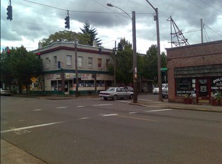
Foster-Powell is a neighborhood in the Southeast section of Portland, Oregon. The triangular neighborhood is bounded by three major transit arteries: Powell Boulevard to the north, Foster Road to the south, and 82nd Avenue to the east.

Montavilla is a neighborhood in the Northeast and Southeast sections of Portland, Oregon, United States, and contains an area east of Mount Tabor and west of Interstate 205, from the Banfield to SE Division. It is bordered by North Tabor, Mount Tabor, South Tabor, Madison South, Hazelwood, and Powellhurst-Gilbert.

<span class="mw-page-title-main">Johnson Creek (Willamette River tributary)</span> Creek in Oregon, USA

Johnson Creek is a 25-mile (40 km) tributary of the Willamette River in the Portland metropolitan area of the U.S. state of Oregon. Part of the drainage basin of the Columbia River, its catchment consists of 54 square miles (140 km2) of mostly urban land occupied by about 180,000 people as of 2012. Passing through the cities of Gresham, Portland, and Milwaukie, the creek flows generally west from the foothills of the Cascade Range through sediments deposited by glacial floods on a substrate of basalt. Though polluted, it is free-flowing along its main stem and provides habitat for salmon and other migrating fish.

<span class="mw-page-title-main">Tryon Creek</span> Tributary of the Willamette River in Oregon

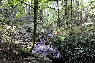
Tryon Creek is a 4.85-mile (7.81 km) tributary of the Willamette River in the U.S. state of Oregon. Part of the drainage basin of the Columbia River, its watershed covers about 6.5 square miles (16.8 km2) in Multnomah and Clackamas counties. The stream flows southeast from the Tualatin Mountains through the Multnomah Village neighborhood of Portland and the Tryon Creek State Natural Area to the Willamette in the city of Lake Oswego. Parks and open spaces cover about 21 percent of the watershed, while single-family homes dominate most of the remainder. The largest of the parks is the state natural area, which straddles the border between the two cities and counties.

<span class="mw-page-title-main">82nd Avenue</span> Street in Portland, Oregon

82nd Avenue of the Roses is a street in Portland, Oregon, and comprises the northern end of Oregon Route 213, also known as the Cascade Highway. It is one of the longest streets in Portland, running down the entire east side of the city, and extending into suburbs to the south.

Hazeltine Park is a 1.02-acre (0.41 ha) park located at 5416 Southeast Flavel Drive, in Portland, Oregon's Brentwood-Darlington neighborhood, in the United States. The park, acquired in 2001, is named after Dick Hazeltine, who is considered the neighborhood's "founder".

<span class="mw-page-title-main">Errol Heights Park</span> Public park in Portland, Oregon, U.S.

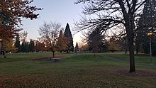
Errol Heights Park, also known as Errol Heights Natural Area, is a 14.25-acre (5.77 ha) public park in Portland, Oregon.

<span class="mw-page-title-main">Oregon's 41st House district</span> Legislative districts in the state of Oregon

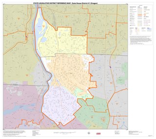
District 41 of the Oregon House of Representatives is one of 60 House legislative districts in the state of Oregon. As of 2013, the boundary for the district includes portions of Clackamas and Multnomah counties. The current representative for the district is Democrat Karin Power of Milwaukie.

<span class="mw-page-title-main">2024 Portland, Oregon City Council election</span>

The 2024 Portland City Council elections will be held on November 5, 2024, to elect the members of Portland's City Council. This will be a unique election as it will be the first election under Portland's new form of government, the first election without a primary, the first election where every seat will be up for election, and the first election under a ranked-choice voting system as opposed to a first-past-the-post voting system with a primary.

References

  1. 1 2 Demographics (2010)
  2. "Archived copy". Archived from the original on 2014-07-15. Retrieved 2014-07-09.{{cite web}}: CS1 maint: archived copy as title (link)
  3. http://www.brentwooddarlington.org/Documents/Brochure.pdf Archived March 15, 2007, at the Wayback Machine Brentwooddarlinton.org
  4. "Brentwood-Darlington neighborhood looks to the future and the past with 'visioning' project". OregonLive.com. 4 May 2013. Retrieved 1 April 2016.
  5. 1 2 3 4 "Find a Park - The City of Portland, Oregon" . Retrieved 1 April 2016.
  6. "Portland State Graduate School of Education: Educational Leadership & Policy - Learning Gardens Laboratory" . Retrieved 1 April 2016.
  7. "Find a Park - The City of Portland, Oregon" . Retrieved 1 April 2016.
  8. "Full-service Grocery Store Opens In Brentwood-Darlington - East PDX News" . Retrieved 1 April 2016.
  9. "Demographics(2010)".
  10. "History of BDNA". 10 June 2013.
  11. 1 2 3 "Brentwood-Darlington Neighborhood Plan".
  12. "City of Portland Annexation History".