
The Tualatin River is a tributary of the Willamette River in Oregon in the United States. The river is about 83 miles (134 km) long, and it drains a fertile farming region called the Tualatin Valley southwest and west of Portland at the northwest corner of the Willamette Valley. There are approximately 500,000 people residing on 15 percent of the land in the river's watershed.

The Rouge River is a river in Markham, Pickering, Richmond Hill and Toronto in the Greater Toronto Area of Ontario, Canada. The river flows from the Oak Ridges Moraine to Lake Ontario at the eastern border of Toronto, and is the location of Rouge Park, the only national park in Canada within a municipality. At its southern end, the Rouge River is the boundary between Toronto and southwestern Pickering in the Regional Municipality of Durham.
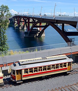
The Willamette Shore Trolley is a heritage railroad or heritage streetcar that operates along the west bank of the Willamette River between Portland and Lake Oswego in the U.S. state of Oregon. The right-of-way is owned by group of local-area governments who purchased it in 1988 in order to preserve it intact for possible rail transit use in the future. Streetcar excursion service began operating on a trial basis in 1987, lasting about three months, and regular operation on a long-term basis began in 1990. The Oregon Electric Railway Historical Society has been the line's operator since 1995.

Oneida Lake is the largest lake entirely within New York State, with a surface area of 79.8 square miles (207 km2). The lake is located northeast of Syracuse and near the Great Lakes. It feeds the Oneida River, a tributary of the Oswego River, which flows into Lake Ontario. From the earliest times until the opening of the Erie Canal in 1825, the lake was part of an important waterway connecting the Atlantic seaboard of North America to the continental interior.

Forest Park is a public municipal park in the Tualatin Mountains west of downtown Portland, Oregon, United States. Stretching for more than 8 miles (13 km) on hillsides overlooking the Willamette River, it is one of the country's largest urban forest reserves. The park, a major component of a regional system of parks and trails, covers more than 5,100 acres (2,064 ha) of mostly second-growth forest with a few patches of old growth. About 70 miles (110 km) of recreational trails, including the Wildwood Trail segment of the city's 40-Mile Loop system, crisscross the park.

The Portland metropolitan area or Greater Portland is a metropolitan area in the U.S. states of Oregon and Washington centered on the principal city of Portland, Oregon. The U.S. Office of Management and Budget identifies it as the Portland–Vancouver–Hillsboro, OR–WA Metropolitan Statistical Area, a metropolitan statistical area used by the United States Census Bureau (USCB) and other entities. The OMB defines the area as comprising Clackamas, Columbia, Multnomah, Washington, and Yamhill Counties in Oregon, and Clark and Skamania Counties in Washington. The area's population is estimated at 2,753,168 in 2017.

Oregon Route 43 is an Oregon state highway that runs between the cities of Oregon City and Portland, mostly along the western flank of the Willamette River. While it is technically known by the Oregon Department of Transportation as the Oswego Highway No. 3, on maps it is referred to by its route number or by the various street names it has been given.

Collins View is a neighborhood in the Southwest section of Portland, Oregon. It borders the neighborhoods of Marshall Park and Arnold Creek to the west, Tryon Creek State Natural Area to the south, Dunthorpe, River View Cemetery and River View Natural Area to the east, and the South Burlingame neighborhood to the north. The campus of Lewis and Clark College is in the southeastern portion of the neighborhood.
West Portland Park is a neighborhood in the Southwest section of Portland, Oregon. It lies between SW 53rd Ave. in the west and SW 35th Ave. in the east, and I-5 in the north and SW Stephenson St. in the south. South of SW Pomona St., the western border is SW 49th Ave. The neighborhood borders Crestwood and Far Southwest to the west, Multnomah to the north, Markham and Arnold Creek to the east, and the city of Lake Oswego to the south.
Markham is a neighborhood in the Southwest section of Portland, Oregon. Markham is bordered by Multnomah and South Burlingame on the north, Marshall Park on the east, Arnold Creek on the south, and West Portland Park on the west.
Marshall Park is a neighborhood in the Southwest section of Portland, Oregon. It gets its name from the adjacent Marshall Park donated to the City of Portland by Frederick C. and Addie Mae Marshall in 1948. It borders Markham to the west and north, South Burlingame to the north, Collins View to the east, and Arnold Creek to the south.
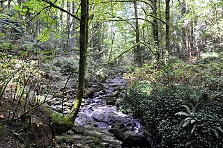
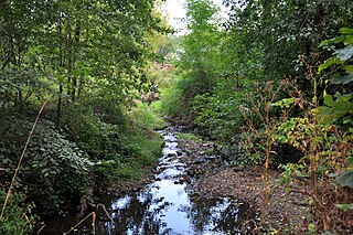
Tryon Creek is a 4.85-mile (7.81 km) tributary of the Willamette River in the U.S. state of Oregon. Part of the drainage basin of the Columbia River, its watershed covers about 6.5 square miles (16.8 km2) in Multnomah and Clackamas counties. The stream flows southeast from the Tualatin Mountains through the Multnomah Village neighborhood of Portland and the Tryon Creek State Natural Area to the Willamette in the city of Lake Oswego. Parks and open spaces cover about 21 percent of the watershed, while single-family homes dominate most of the remainder. The largest of the parks is the state natural area, which straddles the border between the two cities and counties.

The Tryon Creek State Natural Area is a state park located primarily in Portland, in the U.S. state of Oregon. It is the only Oregon state park within a major metropolitan area. The 645-acre (261 ha) park lies between Boones Ferry Road and Terwilliger Boulevard in southwest Portland in Multnomah County and northern Lake Oswego in Clackamas County and is bisected from north to south by Tryon Creek.
The Willamette River flows northwards down the Willamette Valley until it meets the Columbia River at a point 101 miles from the Pacific Ocean, in the U.S. state of Oregon.

Socrates Hotchkiss Tryon Sr. was a pioneer physician in what became the U.S. state of Oregon. A native of Vermont, he later lived in Iowa and California before moving to the Oregon Territory where he settled the land that now comprises part of the Tryon Creek State Natural Area in Portland and Lake Oswego. He was also a member of the 1846 Iowa Constitutional Convention.
Stephens Creek, a 2-mile (3 km) tributary of the Willamette River, flows entirely within the city of Portland in the U.S. state of Oregon. Beginning in the neighborhood of Hillsdale, it runs generally east through residential and commercial neighborhoods as well as patches of forest and parkland to join the Willamette slightly north of the Sellwood Bridge. Its course passes under Interstate 5 and down the canyon followed by Southwest Taylors Ferry Road. Stephens Creek enters the river at Willamette Moorage Park, which is part of a 35-acre (14 ha) group of natural areas called the South Portland Riverbank. The natural areas include Butterfly Park and Willamette Park as well as the moorage park and other public land parcels.

Kellogg Creek is a tributary, about 4.5 miles (7.2 km) long, of the Willamette River in the Portland metropolitan area of the U.S. state of Oregon. It begins near Lake Lenore in Johnson City and flows northwest to meet the river at Milwaukie. Kellogg Creek is joined about midway along its course by Mount Scott Creek, its major tributary, which enters the main stem near North Clackamas Central Park.

Floras Lake is a natural 236-acre (96 ha) body of water on the southern Oregon Coast of the United States. Fed by four small tributaries from a basin of about 10 square miles (26 km2) in Curry County, it lies about 10 miles (16 km) north of Port Orford and 2 miles (3 km) west of U.S. Route 101. It was probably named for Fred Flora, a 19th-century settler and miner who lived nearby.
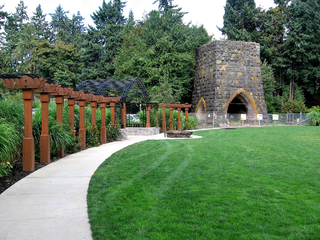
George Rogers Park is a 26-acre (11 ha) public park at intersection of Ladd and South State streets in Lake Oswego, Oregon, United States. This park contains two baseball fields, a soccer field, access to the Willamette River, a memorial garden area, restrooms, a playground, and two outdoor tennis courts. The park also features the Oregon Iron Company Furnace, which was placed on the National Register of Historic Places by the Department of the Interior. The park is named after George Rogers—a City Councilman—in appreciation for his devoted efforts to develop and maintain the grounds.


