
Portland is the largest and most populous city in the U.S. state of Oregon and the seat of Multnomah County. It is a major port in the Willamette Valley region of the Pacific Northwest, at the confluence of the Willamette and Columbia rivers in Northwestern Oregon. As of 2019, Portland had an estimated population of 654,741, making it the 26th most populated city in the United States, the sixth-most populous on the West Coast, and the second-most populous in the Pacific Northwest after Seattle. Approximately 2.4 million people live in the Portland metropolitan statistical area (MSA), making it the 25th most populous in the United States. Its combined statistical area (CSA) ranks 19th-largest with a population of around 3.2 million. Approximately 47% of Oregon's population resides within the Portland metropolitan area.

Oregon City is the county seat of Clackamas County, Oregon, United States, located on the Willamette River near the southern limits of the Portland metropolitan area. Established in 1829 by the Hudson's Bay Company, in 1844 it became the first U.S. city west of the Rocky Mountains to be incorporated.

St. Johns is a neighborhood of Portland, Oregon, United States, located in North Portland on the tip of the peninsula formed by the confluence of the Willamette River and the Columbia River. It was a separate, incorporated city from 1902 until 1915, when citizens of both St. Johns and Portland voted to approve its annexation to Portland, which took effect on July 8, 1915.

Maplewood is a suburban neighborhood in Southwest Portland, Oregon, United States.
Alameda is a neighborhood in Portland, Oregon, United States that is located on the Alameda Ridge with views of Downtown, the Willamette River, and the Cascades. Northeast Fremont Street is the neighborhood's main east-west thoroughfare and NE 33rd, its main north-south thoroughfare, makes up its eastern boundary. The neighborhood is adjacent to Wilshire Park, a 14.4-acre (58,000 m2) neighborhood park. The community's side streets wind around the hill, past cottages and expansive Craftsman homes. Alameda is located between the business districts of Beaumont Village and the Hollywood District. Locals informally refer to the neighborhood as the Yarn District for its abundance of yarn-based hobbyists.
Northwest Heights is a neighborhood on the west side of Portland. It is generally regarded as a wealthy neighborhood. The home ownership rate is among the highest in the state, at 83%. The neighborhood has a population of 5,505 as of 2020. It is colloquially known as “Forest Heights”, and was rapidly constructed throughout the 90’s. The neighborhood is split into two parts by Northwest Thompson Road, which creates a northern side and southern side.
Homestead is a Southwest Portland, Oregon, United States, neighborhood in the city's West Hills. The neighborhood is home to Marquam Nature Park, which offers urban hiking in the form of the Marquam Trail, which one can follow to Downtown. Scenic Terwilliger Boulevard also passes through the neighborhood.

Ardenwald-Johnson Creek is a neighborhood straddling the border between Portland and Milwaukie, Oregon. It is recognized by both Portland's Office of Neighborhood Involvement as well as Milwaukie's Neighborhoods Program.
Brentwood-Darlington is a neighborhood on the southern edge of Portland, Oregon, bordering SE 45th Avenue to the west, SE Duke Street to the north, and SE 82nd Avenue to the east. The county line separating Multnomah County from Clackamas County forms most of the neighborhood's southern boundary, though small portions of the neighborhood and the city extend into Clackamas County. Roughly, the southern boundary is SE Harney Drive on the eastern one-fourth, and SE Clatsop Street on the other three-quarters.
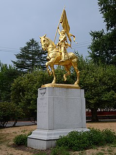
Laurelhurst is a neighborhood of vintage homes and undulating streets surrounding a park of the same name, straddling the NE and SE sections of Portland. Stone markers flank the entrances to the area. The center of the neighborhood, Coe Circle, contains a gilded equestrian statue of Joan of Arc, which is a World War I war memorial. The Laurelhurst Historic District was officially listed in the National Register of Historic Places In 2019.
Buckman is a neighborhood in the Southeast section of Portland, Oregon. The neighborhood is bounded by the Willamette River on the west, E Burnside St. on the north, SE 28th Ave. on the east, and SE Hawthorne Blvd. on the south.

Concordia is a neighborhood in the Northeast section of Portland, Oregon, United States, named after Concordia University, which is located within it. The neighborhood borders are NE 22nd Ave. on the west, NE Columbia Blvd. on the north, and NE 42nd Ave. on the east. On the south, the border is NE Prescott St. and NE Alberta Ct., to the west and east of NE 33rd Ave., respectively. Neighborhoods bordering Concordia are Woodlawn, Vernon, and Sabin on the west, Sunderland on the north, Cully on the east, and Alameda and Beaumont-Wilshire on the south.

Rose City Park is a neighborhood in Northeast Portland, Oregon. It borders Beaumont-Wilshire, Grant Park, and the Hollywood District on the west, Cully on the north, Roseway and Madison South on the east, and Center on the south.
Portsmouth is a neighborhood in the north section of Portland, Oregon, United States. It is bordered by Columbia Boulevard to the north, Lombard Street to the south, Chautauqua Boulevard to the east, and a BNSF Railway cut to the west.
Richmond is a neighborhood in the Southeast section of Portland, Oregon. It borders Sunnyside on the north, Mt. Tabor and South Tabor on the east, Creston-Kenilworth on the south, and Hosford-Abernethy on the west.

Jeffrey Alan Merkley is an American politician serving as the junior United States senator from Oregon since 2009. A member of the Democratic Party, Merkley served as the 64th speaker of the Oregon House of Representatives from 2007 to 2009.

Foster-Powell is a neighborhood in the Southeast section of Portland, Oregon. The triangular neighborhood is bounded by three major transit arteries: Powell Boulevard to the north, Foster Road to the south, and 82nd Avenue to the east.

The 2008 United States Senate election in Oregon was held on November 4, 2008. Incumbent Republican U.S. Senator Gordon H. Smith sought reelection to a third term. Smith was the only Republican Senator from the West Coast and the only Republican holding statewide office in Oregon. He was opposed by Democrat Jeff Merkley, the Speaker of the Oregon House of Representatives, and David Brownlow of the Constitution Party of Oregon. Merkley won by a narrow margin, with Smith not conceding until two days after the election. Merkley became the first Democrat to win this seat since 1960.
Montavilla is a neighborhood in the Northeast and Southeast sections of Portland, Oregon, United States, and contains an area east of Mount Tabor and west of Interstate 205, from the Banfield to SE Division. It is bordered by North Tabor, Mount Tabor, Madison South, Hazelwood, and Powellhurst-Gilbert.
Portland, Maine, is home to many neighborhoods.
