
Gresham is a city located in Multnomah County, Oregon, United States, immediately east of Portland. It is considered a suburb within the Greater Portland Metropolitan area. Though it began as a settlement in the mid-1800s, it was not officially incorporated as a city until 1905; it was named after Walter Quintin Gresham, the American Civil War general and United States Secretary of State.

Troutdale is a city in Multnomah County, Oregon, United States, immediately north of Gresham and east of Wood Village. As of the 2020 census, the city population was 16,300. The city serves as the western gateway to the Historic Columbia River Highway, the Mount Hood Scenic Byway, and the Columbia River Gorge. It is approximately 12 miles (19 km) east of Portland.

The Portland metropolitan area is a metro area with its core in the U.S. states of Oregon and Washington. It has 5 principal cities the largest being Portland, Oregon. The U.S. Office of Management and Budget (OMB) identifies it as the Portland–Vancouver–Hillsboro, OR–WA Metropolitan Statistical Area, a metropolitan statistical area used by the United States Census Bureau (USCB) and other entities. The OMB defines the area as comprising Clackamas, Columbia, Multnomah, Washington, and Yamhill Counties in Oregon, and Clark and Skamania Counties in Washington. The area had a population of 2,512,859 at the 2020 census, an increase of over 12% since 2010.
Hazel Dell is an unincorporated area and census-designated place (CDP) in Clark County, Washington, United States, located north and west of Vancouver. As of the 2010 census the population was 19,435. Previous censuses divided the community into two areas, Hazel Dell North and Hazel Dell South.

Interstate 205 (I-205) is an auxiliary Interstate Highway in the Portland metropolitan area of Oregon and Washington, United States. The north–south freeway serves as a bypass route of I-5 along the east side of Portland, Oregon, and Vancouver, Washington. It intersects several major highways and serves Portland International Airport.
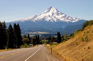
The Mount Hood Highway No. 26 is the Oregon Department of Transportation's designation for a 96.74-mile-long (155.69 km) highway from Portland east around the south side of Mount Hood and north via Bennett Pass to Hood River. It is marked as U.S. Route 26 from Portland to near Mount Hood and Oregon Route 35 the rest of the way to Hood River.
The Mount Hood Freeway is a partially constructed but never to be completed freeway alignment of U.S. Route 26 and Interstate 80N, which would have run through southeast Portland, Oregon. Related projects would have continued the route through the neighboring suburb of Gresham, out to the city of Sandy.

Ardenwald-Johnson Creek is a neighborhood straddling the border between Portland and Milwaukie, Oregon. It is recognized by both Portland's Office of Neighborhood Involvement as well as Milwaukie's Neighborhoods Program.

The Lents neighborhood in the Southeast section of Portland, Oregon is bordered by SE Powell Blvd. on the north, the Clackamas County line or City of Portland line on the south, SE 82nd Ave. to the west, and roughly SE 112th on the east. The NE corner overlaps with the Powellhurst-Gilbert neighborhood. In addition to Powellhurst-Gilbert on the north and east, Lents also borders Foster-Powell, Mt. Scott-Arleta, and Brentwood-Darlington on the west and Pleasant Valley on the east.

Rose City Park is a neighborhood in Northeast Portland, Oregon. It borders Beaumont-Wilshire, Grant Park, and the Hollywood District on the west, Cully on the north, Roseway and Madison South on the east, and Center on the south.
Madison South is a neighborhood in the Northeast section of Portland, Oregon. It is bordered by the Roseway, Sumner, Cully, Parkrose, Montavilla, and Rose City Park neighborhoods, and by the enclave city of Maywood Park. The neighborhood roughly conforms to the boundaries of Interstate 84 to the south, Interstate 205 to the east, NE Sandy Boulevard to the north, and NE 65th Avenue to the west.
Glenfair is a small neighborhood spanning the Northeast and Southeast sections of Portland, Oregon, on the city's eastern border with Gresham. It is bordered by the Wilkes, Hazelwood, and Centennial neighborhoods in Portland, as well as the City of Gresham to the east. Its boundaries are NE Glisan Street, 148th Avenue, SE Stark, and 161st Street.
Parkrose is a neighborhood in the Northeast section of Portland, Oregon, and is considered part of East Portland. It is bordered by Sumner to the west, the Columbia River to the north, Argay to the east, and Parkrose Heights and the city of Maywood Park to the south. Sandy Boulevard crosses the neighborhood, with a primarily industrial area prevailing to the north and primarily residential area to the south.

Johnson Creek is a 25-mile (40 km) tributary of the Willamette River in the Portland metropolitan area of the U.S. state of Oregon. Part of the drainage basin of the Columbia River, its catchment consists of 54 square miles (140 km2) of mostly urban land occupied by about 180,000 people as of 2012. Passing through the cities of Gresham, Portland, and Milwaukie, the creek flows generally west from the foothills of the Cascade Range through sediments deposited by glacial floods on a substrate of basalt. Though polluted, it is free-flowing along its main stem and provides habitat for salmon and other migrating fish.

Interstate 84 (I-84) in the U.S. state of Oregon is a major Interstate Highway that traverses the state from west to east. It is concurrent with U.S. Route 30 (US 30) for most of its length and runs 376 miles (605 km) from an interchange with I-5 in Portland to the Idaho state line near Ontario. The highway roughly follows the Columbia River and historic Oregon Trail in northeastern Oregon, and is designated as part of Columbia River Highway No. 2 and all of the Old Oregon Trail Highway No. 6; the entire length is also designated as the Vietnam Veterans Memorial Highway. I-84 intersects several of the state's main north–south roads, including US 97, US 197, I-82, and US 395.

The Columbia Slough is a narrow waterway, about 19 miles (31 km) long, in the floodplain of the Columbia River in the U.S. state of Oregon. From its source in the Portland suburb of Fairview, the Columbia Slough meanders west through Gresham and Portland to the Willamette River, about 1 mile (1.6 km) from the Willamette's confluence with the Columbia. It is a remnant of the historic wetlands between the mouths of the Sandy River to the east and the Willamette River to the west. Levees surround much of the main slough as well as many side sloughs, detached sloughs, and nearby lakes. Drainage district employees control water flows with pumps and floodgates. Tidal fluctuations cause reverse flow on the lower slough.
Russell is a neighborhood in the northeast section of Portland, Oregon, United States. Russell lies between Interstate 84 on the north and NE Halsey St. on the south, and between NE 122nd Ave on the west and NE 142nd Ave. on the east. It borders Argay on the north, Wilkes on the east, Hazelwood on the south, and Parkrose Heights on the west.

Rockwood is a neighborhood in the northwest section of Gresham, Oregon. It is one of the most densely populated and diverse neighborhoods in Gresham, though it is also one of the poorest in the state.

82nd Avenue of the Roses is a street in Portland, Oregon, and comprises the northern end of Oregon Route 213, also known as the Cascade Highway. It is one of the longest streets in Portland, running down the entire east side of the city, and extending into suburbs to the south.

Lombard Street is a main thoroughfare in Portland, Oregon, United States. It serves as a boundary and main commercial street for several north Portland neighborhoods.

