
Portland is the largest and most populous city in the U.S. state of Oregon and the seat of Multnomah County. It is a major port in the Willamette Valley region of the Pacific Northwest, at the confluence of the Willamette and Columbia rivers in Northwestern Oregon. As of 2019, Portland had an estimated population of 654,741, making it the 26th most populated city in the United States, the sixth-most populous on the West Coast, and the second-most populous in the Pacific Northwest after Seattle. Approximately 2.4 million people live in the Portland metropolitan statistical area (MSA), making it the 25th most populous in the United States. Its combined statistical area (CSA) ranks 19th-largest with a population of around 3.2 million. Approximately 47% of Oregon's population resides within the Portland metropolitan area.
The Cotton Club was a nightclub located in North Portland, Oregon. Located at 2125 N. Vancouver Avenue, the club gained attention during the 1960s as the "only nightclub on the West Coast with wall-to-wall soul." Celebrities such as Cab Calloway, Sammy Davis, Jr., Cass Elliot, the Kingston Trio, Joe Louis, and Archie Moore would visit the nightclub when they were in town.

South Portland is a long, narrow neighborhood just south of Downtown Portland, Oregon, and the newest of the city's sextants, hemmed in between the Willamette River and the West Hills. It stretches from I-405 and the Marquam Bridge on the north, to SW Canby St. and the Sellwood Bridge in the south. The Willamette forms the eastern boundary, and SW Barbur Blvd. most of the western boundary. In addition to Downtown to the north, other bordering neighborhoods are Southwest Hills, Homestead, Hillsdale, and South Burlingame to the west, and Hosford-Abernethy, Brooklyn, and Sellwood-Moreland across the river on the east.
The Beaumont-Wilshire neighborhood of Portland, Oregon is located in the city's northeast section, on Alameda Ridge with views of Downtown, the Willamette River, and the Cascades. It is bordered by the Alameda, Concordia, Cully, Rose City Park, and Grant Park neighborhoods. "Beaumont Village", located on NE Fremont Street, from NE 33rd Ave. to NE 50th Ave., is the main commercial district in the neighborhood, but the neighborhood also lies within walking distance of the Hollywood District, a major commercial and shopping area to the south.
Brentwood-Darlington is a neighborhood on the southern edge of Portland, Oregon, bordering SE 45th Avenue to the west, SE Duke Street to the north, and SE 82nd Avenue to the east. The county line separating Multnomah County from Clackamas County forms most of the neighborhood's southern boundary, though small portions of the neighborhood and the city extend into Clackamas County. Roughly, the southern boundary is SE Harney Drive on the eastern one-fourth, and SE Clatsop Street on the other three-quarters.
Irvington is a neighborhood in the Northeast section of Portland, Oregon. According to the city's Office of Community and Civic Life, it consists of a rectangular area extending east to west from NE 7th Ave. to NE 26th Ave., and north to south from NE Fremont St. to NE Broadway. It borders the King, Sabin, and Alameda neighborhoods to the north; Alameda and Grant Park to the east; Sullivan's Gulch and the Lloyd District to the south; and Eliot to the west.
Sunnyside is a neighborhood in the south east section of Portland, between SE Stark Street and SE Hawthorne Blvd. and from SE 28th Ave. to SE 49th Ave.. The Sunnyside Neighborhood motto is "Proud Past, Bright Future". Sunnyside has a "strong sense of Portland individuality" with many locally owned coffee shops and businesses. Sunnyside is sometimes referred to as the Belmont neighborhood, for its main commercial street. Sunnyside is bordered by Laurelhurst to the north, Richmond to the south, Buckman to the west, and Mount Tabor to the east. Because of its Victorian architecture and bohemian culture, Hawthorne/Belmont is often compared to San Francisco's Haight Ashbury district. Sunnyside has been called Portland's "uncontested champion of eco-consciousness".
Buckman is a neighborhood in the Southeast section of Portland, Oregon. The neighborhood is bounded by the Willamette River on the west, E Burnside St. on the north, SE 28th Ave. on the east, and SE Hawthorne Blvd. on the south.
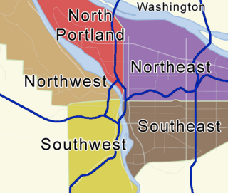
Portland, Oregon is divided into six sections, as of May 1, 2020: North Portland, Northeast Portland, Northwest Portland, South Portland, Southeast Portland, and Southwest Portland. There are 95 officially recognized neighborhoods, each of which is represented by a volunteer-based neighborhood association. No neighborhood associations overlap the Willamette River, but a few overlap the addressing sextants. For example, most addresses in the South Portland Neighborhood Association are South, but a portion of the neighborhood is west of SW View Point Terrace where addresses have a SW prefix. Similarly the Buckman Neighborhood Association spans both NE and SE Portland.
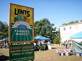
The Lents neighborhood in the Southeast section of Portland, Oregon is bordered by SE Powell Blvd. on the north, the Clackamas County line or City of Portland line on the south, SE 82nd Ave. to the west, and roughly SE 112th on the east. The NE corner overlaps with the Powellhurst-Gilbert neighborhood. In addition to Powellhurst-Gilbert on the north and east, Lents also borders Foster-Powell, Mt. Scott-Arleta, and Brentwood-Darlington on the west and Pleasant Valley on the east.
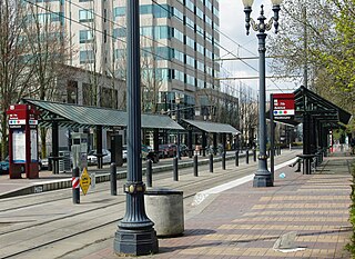
The Lloyd District is a primarily commercial neighborhood in the North and Northeast sections of Portland, Oregon. It is named after Ralph Lloyd (1875–1953), a California rancher, oilman, and real estate developer who moved to and started the development of the area.

Concordia is a neighborhood in the Northeast section of Portland, Oregon, United States, named after Concordia University, which is located within it. The neighborhood borders are NE 22nd Ave. on the west, NE Columbia Blvd. on the north, and NE 42nd Ave. on the east. On the south, the border is NE Prescott St. and NE Alberta Ct., to the west and east of NE 33rd Ave., respectively. Neighborhoods bordering Concordia are Woodlawn, Vernon, and Sabin on the west, Sunderland on the north, Cully on the east, and Alameda and Beaumont-Wilshire on the south.

Rose City Park is a neighborhood in Northeast Portland, Oregon. It borders Beaumont-Wilshire, Grant Park, and the Hollywood District on the west, Cully on the north, Roseway and Madison South on the east, and Center on the south.
Overlook is a neighborhood in the North section of Portland, Oregon on the east shore of the Willamette River. It borders University Park and Arbor Lodge on the north, Humboldt and Boise on the east, Eliot on the southeast, and Northwest Industrial and the Northwest District across the Willamette on the west.
Eliot is a neighborhood in the North and Northeast sections of Portland, Oregon. It is approximately bounded by the Willamette River on the west, NE Fremont Street on the north, NE 7th Avenue on the east, and NE/N Broadway on the south.
King is a neighborhood in the northeast section of Portland, Oregon, United States. Like many of the surrounding neighborhoods, King has historically had one of the highest proportions of non-white residents in the city. Census data taken 2010 show that the neighborhood was 60.1% white.
Roseway is a neighborhood in the Northeast section of Portland, Oregon. It is bordered by the neighborhoods Cully to the north and west, Sumner to the northeast, Madison South to the east and south, and Rose City Park to the west

North Williams Avenue is a north-south street located in Portland, Oregon, United States, and it defines the eastern boundary of North Portland. North Williams Avenue stretches from its southern terminus at Northeast Winning Way, near the Moda Center, to its northern terminus at North Winchell Street, a distance of 3.3 miles (5.3 km). It is a street common to the Portland neighborhoods Eliot, Boise, Humboldt, and Piedmont.

The Mayo House is a historical house built by Martin Nicholas Mayo in the 1890s. It was built in Portland, Oregon's Eliot neighborhood. It is notable for being relocated in 1912, 1930, and 2019 to avoid demolition in order to make room for new construction projects. The house utilizes the Queen Anne architecture style. The relocation of the house in 2019 will see the house repurposed by local artist Cleo Davis as a site for local art and history to be archived and made available for the public. This new archive will be used to show the history of African-Americans in the local area of Portland. In order to reduce the cost of the relocation, the Portland City Council waived $40,000 in fees. The house was relocated in late January 2019.

Albina is a collection of neighborhoods located in the North and Northeast sections of Portland, Oregon, United States. For most of the 20th century it was home to the majority of the city’s African American population. The area derives its name from Albina, Oregon, a historical American city that was consolidated into Portland in 1891. Albina includes the modern Portland neighborhoods of Eliot, Boise, Humboldt, Irvington, King, Overlook, and Piedmont.

