Interstate 205 (I-205) is an auxiliary Interstate Highway in the Portland–Vancouver metropolitan area in the U.S. states of Oregon and Washington. It serves as a bypass route of I-5 that travels north–south along the east side of both cities and their suburbs, intersecting several major highways and serving the Portland International Airport.

Brewerytown is a neighborhood in the North Central Philadelphia district of the city of Philadelphia, Pennsylvania, United States. An unofficial region, Brewerytown runs approximately between the Schuylkill River's eastern bank and 25th Street, bounded by Cecil B. Moore Avenue to the north and Parrish Street to the south. Brewerytown got its name because of the numerous breweries that were located along the Schuylkill during the late 19th century and early 20th century. It is now primarily a residential neighborhood, with a growing and active commercial sector along Girard Avenue.

The Northwest District is a densely populated retail and residential neighborhood in the northwest section of Portland, Oregon. Craftsman-style and Old Portland-style houses are packed tightly together with grand old apartment buildings and sleek new condominiums, within walking distance of restaurants, bars, and shops. The Portland Streetcar's first line terminates there, connecting the district to the Pearl District, Downtown Portland and points south to the South Waterfront, and several TriMet bus lines also serve the district.
South Portland is a long, narrow neighborhood just south of Downtown Portland, Oregon, hemmed in between the Willamette River and the West Hills. It stretches from I-405 and the Marquam Bridge on the north, to SW Canby St. and the Sellwood Bridge in the south. The Willamette forms the eastern boundary, and SW Barbur Blvd. most of the western boundary. In addition to Downtown to the north, other bordering neighborhoods are Southwest Hills, Homestead, Hillsdale, and South Burlingame to the west, and Hosford-Abernethy, Brooklyn, and Sellwood-Moreland across the river on the east.
Argay is a neighborhood in the Northeast section of Portland, Oregon. Argay is bounded by the Columbia River on the north, NE 122nd Ave on the west, Interstate 84 on the south, and NE 148th Ave. on the east. Originally conceived of by Art Simonson and Gerhardt (Gay) Stabney as a “move-up” suburban family neighborhood alternative to Portland's congested inner-city, Argay Terrace built out as planned with larger, better quality homes on large lots spread out over the gently sloping terrain that gave the area an open feeling and many of its homes stunning views of Mt. Hood and Mt. St. Helens. Homes are typical of the style called “Mid-Century Modern” with a mix of one story ranches, split entry, split level, and even some modern two story colonials.
The Beaumont-Wilshire neighborhood of Portland, Oregon is located in the city's northeast section, on Alameda Ridge with views of Downtown, the Willamette River, and the Cascades. It is bordered by the Alameda, Concordia, Cully, Rose City Park, and Grant Park neighborhoods. "Beaumont Village", located on NE Fremont Street, from NE 33rd Ave. to NE 50th Ave., is the main commercial district in the neighborhood, but the neighborhood also lies within walking distance of the Hollywood District, a major commercial and shopping area to the south.

Boise is a neighborhood in the North and Northeast sections of Portland, Oregon. It is approximately bounded by Interstate 5 on the west, N Skidmore St. on the north, NE Rodney Ave. on the east, and N Kerby St. and NE Fremont St. on the south. The southern portion of N Mississippi Ave. forms the commercial core of the area. The neighborhood was named in honor of Reuben P. Boise, a Portland School Board member during the 1850s.
Irvington is a neighborhood in the Northeast section of Portland, Oregon. According to the city's Office of Community and Civic Life, it consists of a rectangular area extending east to west from NE 7th Ave. to NE 26th Ave., and north to south from NE Fremont St. to NE Broadway. It borders the King, Sabin, and Alameda neighborhoods to the north; Alameda and Grant Park to the east; Sullivan's Gulch and the Lloyd District to the south; and Eliot to the west.
Buckman is a neighborhood in the Southeast section of Portland, Oregon. The neighborhood is bounded by the Willamette River on the west, E Burnside St. on the north, SE 28th Ave. on the east, and SE Hawthorne Blvd. on the south.
North Tabor Neighborhood in Portland, Oregon, United States, is on the east side of the Willamette River on the northern slope of Mount Tabor. The Banfield Expressway forms its northern boundary, separating it from the Hollywood District, Rose City Park, and Madison South neighborhoods to the north. NE/SE 44th Ave. separates it from Laurelhurst to the west and NE 68th Ave. from Montavilla to the east. East Burnside Street forms most of the southern boundary, except for a section west of SE 49th Ave. for which SE Stark Street forms the boundary with the Sunnyside neighborhood.
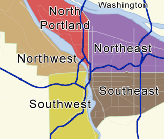
There are five addressing sections of Portland, Oregon, with a sixth to be implemented on May 1, 2020. There are 95 officially recognized neighborhoods, each of which is represented by a volunteer-based neighborhood association. No neighborhood associations overlap the Willamette River, but a few overlap the addressing sextants. For example, most addresses in the South Portland Neighborhood Association are South, but a portion of the neighborhood is west of SW View Point Terrace where addresses have a SW prefix. Similarly the Buckman Neighborhood Association spans both NE and SE Portland. Neighborhood associations serve as the liaison between residents and the city government, as coordinated by the city's Office of Community & Civic Life, which was created in 1974 and known as the Office of Neighborhood Involvement until July 2018. The city subsequently provides funding to this "network of neighborhoods" through district coalitions, which are groupings of neighborhood associations. A few areas of Portland are "unclaimed" by any of the 95 neighborhood associations in Portland.

Concordia is a neighborhood in the Northeast section of Portland, Oregon, United States, named after Concordia University, which is located within it. The neighborhood borders are NE 22nd Ave. on the west, NE Columbia Blvd. on the north, and NE 42nd Ave. on the east. On the south, the border is NE Prescott St. and NE Alberta Ct., to the west and east of NE 33rd Ave., respectively. Neighborhoods bordering Concordia are Woodlawn, Vernon, and Sabin on the west, Sunderland on the north, Cully on the east, and Alameda and Beaumont-Wilshire on the south.

On-street running or street running is the routing of a railroad track or tramway track running directly along public streets, without any grade separation. The rails are embedded in the roadway, and the train shares the street with pedestrians and automobile traffic. Street running trains generally travel at reduced speed for safety reasons.
West Portland Park is a neighborhood in the Southwest section of Portland, Oregon. It lies between SW 53rd Ave. in the west and SW 35th Ave. in the east, and I-5 in the north and SW Stephenson St. in the south. South of SW Pomona St., the western border is SW 49th Ave. The neighborhood borders Crestwood and Far Southwest to the west, Multnomah to the north, Markham and Arnold Creek to the east, and the city of Lake Oswego to the south.
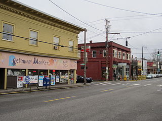
The Belmont Area is a retail and residential district running along SE Belmont St. in the inner Southeast section of Portland, Oregon in a parallel fashion to the Hawthorne District, 6 blocks to the south. From west to east the area extends 48 blocks, from SE 12th Ave. to SE 60th Ave., passing through the Buckman, Sunnyside, and Mount Tabor neighborhoods. The area is seven blocks wide, running from SE Belmont St. 4 blocks north to SE Stark St. and 3 blocks south to SE Salmon St. SE Belmont St. between SE 33rd Ave. and SE 35th Ave., in Sunnyside, is the heart of the district.
Madison South is a neighborhood in the Northeast section of Portland, Oregon. It is bordered by the Roseway, Sumner, Cully, Parkrose, Montavilla, and Rose City Park neighborhoods, and by the enclave city of Maywood Park. The neighborhood roughly conforms to the boundaries of Interstate 84 to the south, Interstate 205 to the east, NE Sandy Boulevard to the north, and NE 65th Avenue to the west.
Roseway is a neighborhood in the Northeast section of Portland, Oregon. It is bordered by the neighborhoods Cully to the north and west, Sumner to the northeast, Madison South to the east and south, and Rose City Park to the west

The Mt. Scott-Arleta neighborhood of Portland, Oregon is located in the city's southeast quadrant. It is bounded on the north by SE Foster Road, west by SE 60th Avenue, east by SE 82nd Avenue, and south by SE Duke. Mt. Scott-Arleta borders the neighborhoods of Woodstock on the west, Foster-Powell on the north, Lents on the east, and Brentwood-Darlington on the south.

The Alameda Ridge is a large gravel bar located in Portland, Oregon, United States.
Burnside Street is a major thoroughfare of Portland, in the U.S. state of Oregon, and one of a few east–west streets that run uninterrupted on both sides of the Willamette River. It serves as the dividing line between North Portland and South Portland. Its namesake bridge, Burnside Bridge, is one of the most heavily traversed in Portland. In Gresham between approximately the east 18300 block to Mt. Hood Hwy, Burnside runs southeast–northwest and is no longer the divide between northeast and southeast on the City of Portland-Multnomah County street grid. Additionally, SE Burnside St becomes NW Burnside Road at SE 202nd/NW Birdsdale Ave, and NE Burnside Rd at N Main Ave in Gresham. Burnside Road's eastern terminus is where it meets Mt. Hood Hwy (US-26), E Powell Blvd (US-26), and SE Powell Valley Road.
