
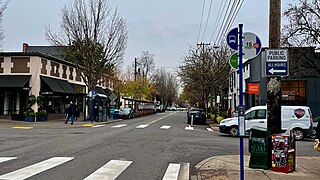
Gresham is a city located in Multnomah County, Oregon, in the United States of America, immediately east of Portland, Oregon. It is considered a suburb within the Greater Portland Metropolitan area. Though it began as a settlement in the mid-1800s, it was not officially incorporated as a city until 1905; it was named after Walter Quintin Gresham, the American Civil War general and United States Secretary of State.

Wemme is an unincorporated community in the northwest United States, located in Clackamas County, Oregon, east of Portland. It is located within the Mount Hood Corridor, between Welches and Brightwood along U.S. Route 26. It is one of the communities that make up the Villages at Mount Hood.

Oregon OR 126 (OR 126) is a 204.63-mile-long (329.32 km) state highway that connects coastal, western, and central parts of the U.S. state of Oregon. A short freeway section of OR 126 in Eugene and Springfield is concurrent with Interstate 105 (I-105).

Ladd's Addition is an inner southeast historic district of Portland, Oregon, United States. It is Portland's oldest planned residential development, and one of the oldest in the western United States. The district is known in Portland for a diagonal street pattern, which is at odds with the rectilinear grid of the surrounding area. Roughly eight blocks (east-west) by ten blocks (north-south) in size, Ladd's is bordered by SE Hawthorne, Division, 12th, and 20th streets. It is part of the Hosford-Abernethy neighborhood association.

Downtown Portland is the central business district of Portland, Oregon, United States. It is on the west bank of the Willamette River in the northeastern corner of the southwest section of the city and where most of the city's high-rise buildings are found.

Trojan Nuclear Power Plant was a pressurized water reactor nuclear power plant in the northwest United States, located southeast of Rainier, Oregon, and the only commercial nuclear power plant to be built in Oregon. There was much public opposition to the plant from the design stage. The three main opposition groups were the Trojan Decommissioning Alliance, Forelaws on the Board, and Mothers for Peace. There were largely non-violent protests from 1977, and subsequent arrests of participants.

Old Town Chinatown is the official Chinatown of the northwest section of Portland, Oregon. The Willamette River forms its eastern boundary, separating it from the Lloyd District and the Kerns and Buckman neighborhoods. It includes the Portland Skidmore/Old Town Historic District and the Portland New Chinatown/Japantown Historic District, which are listed on the National Register of Historic Places. It has been referred to as the "skid row" of Portland.
The Northwest District is a densely populated retail and residential neighborhood in the northwest section of Portland, Oregon, United States. Craftsman-style and Old Portland-style houses are packed tightly together with old apartment buildings and new condominiums, within walking distance of restaurants, bars, and shops. The Portland Streetcar's first line terminates there, connecting the district to the Pearl District, Downtown Portland and points south to the South Waterfront, and several TriMet bus lines also serve the district.

Laurelhurst is a neighborhood of vintage homes and undulating streets surrounding a park of the same name, straddling the NE and SE sections of Portland. Stone markers flank the entrances to the area. The center of the neighborhood, Coe Circle, contains a gilded equestrian statue of Joan of Arc, which is a World War I war memorial. The Laurelhurst Historic District was officially listed on the National Register of Historic Places in 2019.

Buckman is a neighborhood in the Southeast section of Portland, Oregon. The neighborhood is bounded by the Willamette River on the west, E Burnside St. on the north, SE 28th Ave. on the east, and SE Hawthorne Blvd. on the south.
Centennial is a neighborhood on the eastern edge of the Southeast section of Portland, Oregon, on the border with Gresham. The neighborhood includes Lynchwood Park (1993) and Parklane Park (1993).
North Tabor Neighborhood in Portland, Oregon, United States, is on the east side of the Willamette River on the northern slope of Mount Tabor. The Banfield Expressway forms its northern boundary, separating it from the Hollywood District, Rose City Park, and Madison South neighborhoods to the north. NE/SE 44th Avenue separates it from Laurelhurst to the west while NE 68th Avenue separates it from Montavilla to the east. East Burnside Street forms most of the southern boundary, except for a section west of SE 49th Avenue for which SE Stark Street forms the boundary with the Sunnyside neighborhood.
West Coast Airlines was an airline linking small cities in the Pacific Northwest with larger cities in Washington, Oregon, Idaho, Utah, Montana, California and north to Alberta in Canada. It was headquartered in the Westlake area of Seattle, Washington.
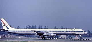
United Airlines Flight 173 was a scheduled flight from John F. Kennedy International Airport in New York City to Portland International Airport in Portland, Oregon, with a scheduled stop in Denver, Colorado. On December 28, 1978, the aircraft flying this route ran out of fuel while troubleshooting a landing gear problem and crashed in a suburban Portland neighborhood near NE 157th Avenue and East Burnside Street, killing 10 on board.
Wilkes is the northeasternmost neighborhood in Portland, Oregon, bordered on the north by the Columbia River and on the east by the city of Gresham. It adjoins the neighborhoods of Argay, Russell, and Hazelwood on the west, and Glenfair on the south. Interstate 84 runs through the middle of the neighborhood.
University Park is a neighborhood in the north section of Portland, Oregon on the east shore of the Willamette River. University Park is bounded by North Lombard Street and the Portsmouth neighborhood to the north, North Chautauqua Boulevard and the Arbor Lodge neighborhood to the east, The Willamette River and Mock's Bottom industrial area to the south, and the North Portland railroad cut with Cathedral Park and St. Johns neighborhoods to the west.
Montavilla is a neighborhood in the Northeast and Southeast sections of Portland, Oregon, United States, and contains an area east of Mount Tabor and west of Interstate 205, from the Banfield to SE Division. It is bordered by North Tabor, Mount Tabor, South Tabor, Madison South, Hazelwood, and Powellhurst-Gilbert.
Powellhurst-Gilbert is a neighborhood in the Southeast section of Portland, Oregon. It borders the neighborhoods of Montavilla, Hazelwood, and Mill Park on the north, Centennial on the east, Pleasant Valley on the east and south, and Lents and South Tabor on the west.

Lower Moyamensing is a neighborhood in South Philadelphia, Pennsylvania, United States, situated just south of the East Passyunk Crossing neighborhood and north of the stadium area. It is bounded by Snyder Avenue to the north, Oregon Avenue to the south, South 7th Street to the east, and South Broad Street to the west. The neighborhood was once part of Moyamensing Township before becoming part of Philadelphia in 1854. Lower Moyamensing is known for its 19th century row homes, factory buildings, and variety of restaurants. South Philadelphia High School is located in Lower Moyamensing, at the corner of Broad and Jackson Streets.
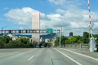
Burnside Street is a major thoroughfare of Portland, in the U.S. state of Oregon, and one of a few east–west streets that runs uninterrupted on both sides of the Willamette River. It serves as the dividing line between North Portland and South Portland. Its namesake bridge, Burnside Bridge, is one of the most heavily traversed in Portland. In Gresham between approximately the east 18300 block to Mt. Hood Hwy, Burnside runs southeast–northwest and is no longer the divide between northeast and southeast on the City of Portland-Multnomah County street grid. Additionally, SE Burnside St becomes NW Burnside Road at SE 202nd/NW Birdsdale Ave, and NE Burnside Rd at N Main Ave in Gresham. Burnside Road's eastern terminus is where it meets Mt. Hood Hwy (US-26), E Powell Blvd (US-26), and SE Powell Valley Road.
