Eastmoreland is an early-twentieth century, tree-filled neighborhood in inner southeast Portland, Oregon, United States. Eastmoreland was named for a local real estate developer, Judge J.C. Moreland.

Milwaukie is a city mostly in Clackamas County, Oregon, United States; a very small portion of the city extends into Multnomah County. The population was 20,291 at the 2010 census. Founded in 1847 on the banks of the Willamette River, the city, known as the Dogwood City of the West, was incorporated in 1903 and is the birthplace of the Bing cherry. The city is now a suburb of Portland and also adjoins the unincorporated areas of Clackamas and Oak Grove.
Brooklyn is a mostly residential neighborhood in southeast Portland, Oregon. It sits along the east side of the Willamette River in the vicinity of Reed College. Founded as a neighborhood in the late 1860s, the neighborhood today is a middle-class area comprising mainly single family homes, interspersed with remaining industrial sites along the river and a large railyard. This railyard was home to Southern Pacific 4449 as well as several other large antique steam and diesel-electric locomotives.
Sellwood-Moreland is a neighborhood on a bluff overlooking the Willamette River in Southeast Portland, Oregon, bordering Brooklyn to the north, Eastmoreland to the east, and the city of Milwaukie to the south. The neighborhood is linked to Southwest Portland across the Willamette River by the Sellwood Bridge, the southernmost of Portland's bridges.

North Clackamas School District (NC12) serves more than 40 square miles and is located 7 miles from downtown Portland. Included are the incorporated cities of Milwaukie, Happy Valley, and Johnson City, parts of Damascus, and the neighborhoods of Oak Grove, Concord, Clackamas, Sunnyside, Mount Scott, Southgate, and Carver. The North Clackamas School District 12 spends $8,053 per pupil in current expenditures. The district spends 59% on instruction, 38% on support services, and 4% on other elementary and secondary expenditures.

Oregon Route 43 is an Oregon state highway that runs between the cities of Oregon City and Portland, mostly along the western flank of the Willamette River. While it is technically known by the Oregon Department of Transportation as the Oswego Highway No. 3, on maps it is referred to by its route number or by the various street names it has been given.
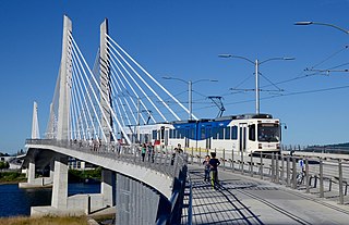
The MAX Orange Line is a light rail service in Portland, Oregon, United States, operated by TriMet as part of the MAX Light Rail system. It connects Portland City Center, Portland State University (PSU), Southeast Portland, Milwaukie, and Oak Grove. The line serves 17 stations from Union Station/Northwest 5th & Glisan to Southeast Park Avenue and runs for 201⁄2 hours daily with a minimum headway of 15 minutes during most of the day. It averaged 3,480 daily weekday riders in September 2020.
Brentwood-Darlington is a neighborhood on the southern edge of Portland, Oregon, bordering SE 45th Avenue to the west, SE Duke Street to the north, and SE 82nd Avenue to the east. The county line separating Multnomah County from Clackamas County forms most of the neighborhood's southern boundary, though small portions of the neighborhood and the city extend into Clackamas County. Roughly, the southern boundary is SE Harney Drive on the eastern one-fourth, and SE Clatsop Street on the other three-quarters.

The Lents neighborhood in the Southeast section of Portland, Oregon is bordered by SE Powell Blvd. on the north, the Clackamas County line or City of Portland line on the south, SE 82nd Ave. to the west, and roughly SE 112th on the east. The NE corner overlaps with the Powellhurst-Gilbert neighborhood. In addition to Powellhurst-Gilbert on the north and east, Lents also borders Foster-Powell, Mt. Scott-Arleta, and Brentwood-Darlington on the west and Pleasant Valley on the east.

Johnson Creek is a 25-mile (40 km) tributary of the Willamette River in the Portland metropolitan area of the U.S. state of Oregon. Part of the drainage basin of the Columbia River, its catchment consists of 54 square miles (140 km2) of mostly urban land occupied by about 180,000 people as of 2012. Passing through the cities of Gresham, Portland, and Milwaukie, the creek flows generally west from the foothills of the Cascade Range through sediments deposited by glacial floods on a substrate of basalt. Though polluted, it is free-flowing along its main stem and provides habitat for salmon and other migrating fish.

The Springwater Corridor Trail is a bicycle and pedestrian rail trail in the Portland metropolitan area in Oregon, United States. It follows a former railway line from Boring through Gresham to Portland, where it ends south of the Eastbank Esplanade. Most of the corridor, about 21 miles (34 km) long, consists of paved, off-street trail, though about 1 mile (1.6 km) overlaps city streets in Portland's Sellwood neighborhood. A large segment roughly follows the course of Johnson Creek and crosses it on bridges many times. Much of the corridor was acquired by the City of Portland in 1990; remaining segments were acquired by Metro thereafter.
The 40-Mile Loop is a partially completed greenway trail around and through Portland in the U.S. state of Oregon. It was proposed in 1903 by the Olmsted Brothers architecture firm as part of the development of Forest Park. One greenway expert calls it "one of the most creative and resourceful greenway projects in the country."

Oregon Pacific Railroad is a short-line railroad operating two disconnected routes: one in southeast Portland, Oregon, and another incorporating portions of the former Southern Pacific Molalla Branch between Canby and Liberal, Oregon.
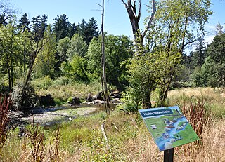
Tideman Johnson Natural Area is a city park of about 7.7 acres (3.1 ha) in southeast Portland, in the U.S. state of Oregon. Located at Southeast 37th Avenue and Tenino Street along Johnson Creek, the site is named for a mid-19th century family named Johnson that encouraged public use of its land along the creek. The park has paved and unpaved paths for hiking. A loop trail and boardwalk off the Springwater Corridor runs through the park.
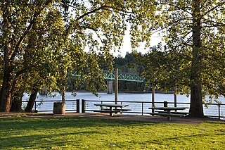
Sellwood Riverfront Park is a city park of about 7.6 acres (3.1 ha) in southeast Portland, in the U.S. state of Oregon. Located at Southeast Spokane Street and Oaks Parkway, the park has paths, picnic tables, a stage, a boat dock on the Willamette River, restrooms, and a dog off-leash area.

Sellwood Park is a city park of about 17 acres (6.9 ha) in southeast Portland, in the U.S. state of Oregon.

82nd Avenue of the Roses is a street in Portland, Oregon, and comprises the northern end of Oregon Route 213, also known as the Cascade Highway. It is one of the longest streets in Portland, running down the entire east side of the city, and extending into suburbs to the south.
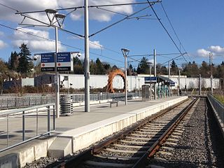
Southeast Tacoma/Johnson Creek is a light rail station and park and ride for the MAX Orange Line. Service began on September 12, 2015. It is the third stop northbound on the Orange Line. The station was built for residents of the Sellwood and Ardenwald neighborhoods of Portland and Milwaukie. The station is located adjacent to Oregon Route 99E and can be directly accessed by northbound traffic and by traffic from the portion of SE Tenino Street that connects SE Tacoma to SE Johnson Creek Boulevard.

Southeast Bybee Boulevard is a light rail station in Portland, Oregon, United States, served by TriMet as part of the MAX Light Rail system. It is the 14th station southbound on the Orange Line, which operates between Portland City Center, Southeast Portland, and Milwaukie. The grade-separated, island platform station adjoins Union Pacific Railroad (UP) freight tracks to the east and McLoughlin Boulevard to the west. Its entrances are located on the Bybee Bridge, which spans over the platform and connects Portland's Sellwood-Moreland and Eastmoreland neighborhoods. Nearby places of interest include Westmoreland Park, Eastmoreland Golf Course, Crystal Springs Rhododendron Garden, Reed College, and the Woodstock neighborhood.

Davis Graveyard is an annual Halloween yard display at a private residence in Milwaukie, Oregon.


