
Portland is the largest and most populous city in the U.S. state of Oregon and the seat of Multnomah County. It is a major port in the Willamette Valley region of the Pacific Northwest, at the confluence of the Willamette and Columbia rivers in Northwestern Oregon. As of 2019, Portland had an estimated population of 654,741, making it the 26th most populated city in the United States, the sixth-most populous on the West Coast, and the second-most populous in the Pacific Northwest after Seattle. Approximately 2.4 million people live in the Portland metropolitan statistical area (MSA), making it the 25th most populous in the United States. Its combined statistical area (CSA) ranks 19th-largest with a population of around 3.2 million. Approximately 47% of Oregon's population resides within the Portland metropolitan area.
Interstate 5 (I-5) is the main north–south Interstate Highway on the West Coast of the United States, running largely parallel to the Pacific coast of the contiguous U.S. from Mexico to Canada. It travels through the states of California, Oregon, and Washington, serving several large cities on the U.S. West Coast, including San Diego, Los Angeles, Sacramento, Portland, and Seattle. It is the only continuous Interstate highway to touch both the Mexican and the Canadian borders. Upon crossing the Mexican border at its southern terminus, I-5 continues to Tijuana, Baja California, as Mexico Federal Highway 1 (Fed. 1). Upon crossing the Canadian border at its northern terminus, it continues to Vancouver as British Columbia Highway 99 (BC 99).
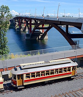
The Willamette Shore Trolley is a heritage railroad or heritage streetcar that operates along the west bank of the Willamette River between Portland and Lake Oswego in the U.S. state of Oregon. The right-of-way is owned by a group of local-area governments who purchased it in 1988 in order to preserve it for potential future rail transit. Streetcar excursion service began operating on a trial basis in 1987, lasting about three months, and regular operation on a long-term basis began in 1990. The Oregon Electric Railway Historical Society has been the line's operator since 1995.

The Tualatin Valley is a farming and suburban region southwest of Portland, Oregon in the United States. The valley is formed by the meandering Tualatin River, a tributary of the Willamette River at the northwest corner of the Willamette Valley, east of the Northern Oregon Coast Range. Most of the valley is located within Washington County, separated from Portland by the Tualatin Mountains. Communities in the Tualatin Valley include Banks, Forest Grove, Cornelius, Hillsboro, Aloha, Beaverton, Sherwood, Tigard, and Tualatin.

Portland Union Station is a train station in Portland, Oregon, United States. It is situated near the western shore of the Willamette River in the city's Old Town Chinatown section. The station serves as an intermediate stop of Amtrak's Cascades and Coast Starlight routes and, along with King Street Station in Seattle, is one of two western termini of the Empire Builder. It is a major transport hub with connections to MAX Light Rail at the Union Station/Northwest 6th & Hoyt and Union Station/Northwest 5th & Glisan stations, the Portland Streetcar, and several local and intercity bus services. The station building contains Wilf's Restaurant & Bar on the ground level and offices on the upper floors. It also has Amtrak's first Metropolitan Lounge on the West Coast, which is reserved for first-class sleeping car and business-class passengers.
Interstate 205 (I-205) is an auxiliary Interstate Highway in the Portland metropolitan area of Oregon and Washington. It serves as a bypass route of I-5, traveling north–south along the east side of Portland, Oregon, and Vancouver, Washington, intersecting several major highways and serving Portland International Airport.

Like transportation in the rest of the United States, the primary mode of local transportation in Portland, Oregon is the automobile. Metro, the metropolitan area's regional government, has a regional master plan in which transit-oriented development plays a major role. This approach, part of the new urbanism, promotes mixed-use and high-density development around light rail stops and transit centers, and the investment of the metropolitan area's share of federal tax dollars into multiple modes of transportation. In the United States, this focus is atypical in an era when automobile use led many areas to neglect their core cities in favor of development along interstate highways, in suburbs, and satellite cities.
Portland is "an international pioneer in transit orientated developments."

Downtown Portland is the city center of Portland, Oregon, United States. It is on the west bank of the Willamette River in the northeastern corner of the southwest section of the city and where most of the city's high-rise buildings are found.

Oregon Route 43 is an Oregon state highway that runs between the cities of Oregon City and Portland, mostly along the western flank of the Willamette River. While it is technically known by the Oregon Department of Transportation as the Oswego Highway No. 3, on maps it is referred to by its route number or by the various street names it has been given.

Cathedral Park is a neighborhood in Portland, Oregon. It is situated on the North Portland peninsula and lies on the east shore of the Willamette River. The neighborhood is named after Cathedral Park, which is located under the St. Johns Bridge, and was given its name due to the Gothic arches that support the bridge, which resemble a cathedral arch.
Interstate 5 (I-5) in the U.S. state of Oregon is a major Interstate Highway that traverses the state from north to south. It travels to the west of the Cascade Mountains, connecting Portland to Salem, Eugene, Medford, and other major cities in the Willamette Valley and across the northern Siskiyou Mountains. The highway runs 308 miles (496 km) from the California state line near Ashland to the Washington state line in northern Portland, forming the central part of Interstate 5's route between Mexico and Canada.
Rail transportation is an important element of the transportation network in the U.S. state of Oregon. Rail transportation has existed in Oregon in some form since 1855, and the state was a pioneer in development of electric railway systems. While the automobile has displaced many uses of rail in the state, rail remains a key means of moving passengers and freight, both within the state and to points beyond its borders.

The Springwater Corridor Trail is a bicycle and pedestrian rail trail in the Portland metropolitan area in Oregon, United States. It follows a former railway line from Boring through Gresham to Portland, where it ends south of the Eastbank Esplanade. Most of the corridor, about 21 miles (34 km) long, consists of paved, off-street trail, though about 1 mile (1.6 km) overlaps city streets in Portland's Sellwood neighborhood. A large segment roughly follows the course of Johnson Creek and crosses it on bridges many times. Much of the corridor was acquired by the City of Portland in 1990; remaining segments were acquired by Metro thereafter.
Fanno Creek is a 15-mile (24 km) tributary of the Tualatin River in the U.S. state of Oregon. Part of the drainage basin of the Columbia River, its watershed covers about 32 square miles (83 km2) in Multnomah, Washington, and Clackamas counties, including about 7 square miles (18 km2) within the Portland city limits.

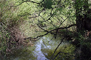
Balch Creek is a 3.5-mile (5.6 km) tributary of the Willamette River in the U.S. state of Oregon. Beginning at the crest of the Tualatin Mountains, the creek flows generally east down a canyon along Northwest Cornell Road in unincorporated Multnomah County and through the Macleay Park section of Forest Park, a large municipal park in Portland. At the lower end of the park, the stream enters a pipe and remains underground until reaching the river. Danford Balch, after whom the creek is named, settled a land claim along the creek in the mid-19th century. After murdering his son-in-law, he became the first person legally hanged in Oregon.

Guild's Lake was a flood-prone lowland near the confluence of Balch Creek with the Willamette River in the U.S. state of Oregon. Indigenous Multnomah people established villages on nearby Sauvie Island but not in the swampy area along the Balch Creek side of the river in what later became northwest Portland. The lake was at an elevation of 33 feet (10 m) above sea level between what later became Northwest Saint Helens Road and Northwest Yeon Street, slightly west of Northwest 35th Avenue in the Northwest Industrial district of Portland.

The Pacific Northwest Corridor or the Pacific Northwest Rail Corridor (PNWRC) is one of eleven federally designated higher-speed rail corridors in the United States. The 466-mile (750 km) corridor extends from Eugene, Oregon to Vancouver, British Columbia via Portland, Oregon and Seattle, Washington in the Pacific Northwest region. It was designated a high-speed rail corridor on October 20, 1992, as the fifth of five corridors called for in the Intermodal Surface Transportation Efficiency Act of 1991 (ISTEA) although it is now called a higher-speed rail since the minimum speed for a high speed rail is designated as 125 miles per hour (201 km/h). The corridor is owned by BNSF Railway in Washington and British Columbia, and by Union Pacific Railroad (UP) in Oregon, and is used by a mix of freight and passenger trains operated by BNSF, UP, and Amtrak. If improvements to the corridor are completed as proposed in Washington State's long range plan, passenger trains operating at a maximum speed of 110 miles per hour (180 km/h) would travel between Portland and Seattle, in 2 hours and 30 minutes, and between Seattle and Vancouver in 2 hours and 37 minutes by 2023.

The Willamette River is a 187-mile (301 km) tributary of the Columbia River in the U.S. state of Oregon. The upper tributaries of the Willamette originate in mountains south and southeast of the twin cities of Eugene and Springfield. Formed by the confluence of the Middle Fork Willamette River and Coast Fork Willamette River near Springfield, the main stem meanders generally north from source to mouth. The river's two most significant course deviations occur at Newberg, where the stream turns sharply east, and about 18 miles (29 km) downriver from Newberg, where it turns north again. Near its mouth, the river splits into two channels that flow around Sauvie Island. The main channel enters the Columbia about 101 miles (163 km) from the larger stream's mouth on the Pacific Ocean, and the smaller Multnomah Channel enters the Columbia about 14.5 miles (23.3 km) further downstream near St. Helens in Columbia County.
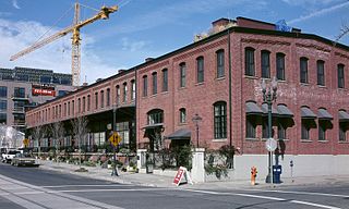
The North Bank Depot Buildings, in central Portland, Oregon, United States, are a pair of buildings formerly used as a freight warehouse and passenger terminal for the Spokane, Portland and Seattle Railway (SP&S). Formed in 1905, the SP&S was commonly known as the North Bank Road during the period in which these buildings were in use. The Portland buildings' passenger facilities were also used by the Oregon Electric Railway after that railway was acquired by the SP&S. Located in what is now known as the Pearl District, the buildings were listed on the National Register of Historic Places in 1996. They were in use by the SP&S and its successor, Burlington Northern Railroad, from 1908 until the 1980s. Only the east building was used as a passenger station, and this usage lasted from 1908 until 1931.

Lombard Street is a main thoroughfare in North and Northeast Portland, Oregon. It serves as a boundary and main commercial street for several North Portland neighborhoods.

