
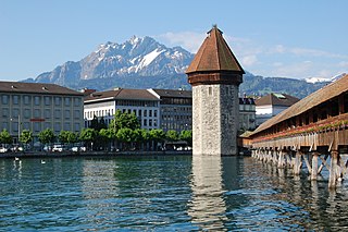
Lucerne or Luzern is a city in central Switzerland, in the German-speaking portion of the country. Lucerne is the capital of the canton of Lucerne and part of the district of the same name. With a population of approximately 82,000 people, Lucerne is the most populous city in Central Switzerland, and a nexus of economics, transportation, culture, and media in the region. The city's urban area consists of 19 municipalities and towns with an overall population of about 220,000 people.
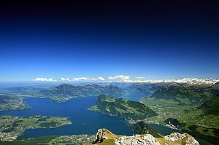
Lake Lucerne is a lake in central Switzerland and the fourth largest in the country.

The canton of Uri is one of the 26 cantons of Switzerland and a founding member of the Swiss Confederation. It is located in Central Switzerland. The canton's territory covers the valley of the Reuss between the St. Gotthard Pass and Lake Lucerne.

The canton of Zug or Zoug is one of the 26 cantons of Switzerland. It is located in central Switzerland and its capital is Zug. At 239 km2 (92 sq mi) the canton is one of the smallest of the Swiss cantons in terms of area. It is not subdivided into districts, but eleven municipalities.

The Battle of Sempach was fought on 9 July 1386, between Leopold III, Duke of Austria and the Old Swiss Confederacy. The battle was a decisive Swiss victory in which Duke Leopold and numerous Austrian nobles died. The victory helped turn the loosely allied Swiss Confederation into a more unified nation and is seen as a turning point in the growth of Switzerland.
The Reuss is a river in Switzerland. With a length of 164 kilometres (102 mi) and a drainage basin of 3,426 square kilometres (1,323 sq mi), it is the fourth largest river in Switzerland. The upper Reuss forms the main valley of the canton of Uri. The course of the lower Reuss runs from Lake Lucerne to the confluence with the Aare at Brugg and Windisch.

The A13 is a motorway, at times an Autostrasse (expressway), which runs from St. Margrethen in northeastern Switzerland through to Ascona in southern Switzerland, crossing the main chain of the Alps in the Grisons area. It is the southern half of European route E43.

The A2 is a motorway in Switzerland. It forms Switzerland's main north–south axis from Basel to Chiasso, meandering with a slight drift toward the east. It lies on the Gotthard axis and crosses the Alps. Opened in 1955 under the name "Road Lucerne-south", A2 is one of the busiest motorways in Switzerland.

Dietwil is a municipality in the district of Muri in the canton of Aargau in Switzerland.

The Gotthard Pass or St. Gotthard Pass at 2,106 m (6,909 ft) is a mountain pass in the Alps traversing the Saint-Gotthard Massif and connecting northern Switzerland with southern Switzerland. The pass lies between Airolo in the Italian-speaking canton of Ticino, and Andermatt in the German-speaking canton of Uri, and connects further Bellinzona and Lugano to Lucerne, Basel, and Zurich. The Gotthard Pass lies at the heart of the Gotthard, a major transport axis of Europe, and it is crossed by three traffic tunnels, each being the world's longest at the time of their construction: the Gotthard Rail Tunnel (1882), the Gotthard Road Tunnel (1980) and the Gotthard Base Tunnel (2016). With the Lötschberg to the west, the Gotthard is one of the two main north-south routes through the Swiss Alps.
Switzerland has a two-class highway system: motorways with separated roads for oncoming traffic and a standard maximal speed limit of 120 kilometres per hour (75 mph), and expressways often with oncoming traffic and a standard maximal speed limit of 100 kilometres per hour (62 mph).
Buchrain is a municipality in the district of Lucerne in the canton of Lucerne in Switzerland.

Risch is a municipality in the canton of Zug in Switzerland. It is also promoted as Risch-Rotkreuz. Four villages belong to the municipality Risch. On 24 November 2007 it was decided to promote the municipality as Risch-Rotkreuz. The change was made because the village Rotkreuz has become much bigger than Risch.
The Oberaargau is the region that encompasses the upper watershed of the Aar River in the canton of Bern in Switzerland. On the north, lie the Jura Mountains, and on the south the hills leading to the Emmental.

The A16, a motorway in north-central Switzerland, is a divided freeway connecting the border to France to the A5 motorway, 84 kilometres (52 mi) to the south on the Swiss plateau.
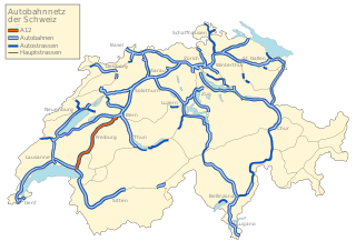
The A12 motorway, an Autobahn in western Switzerland, is a divided highway connecting the A9 to the A1.

The A6 motorway, an Autobahn in Switzerland, connects Biel / Bienne over Bern with Thun. The A6 is located entirely within the Canton of Berne and, in particular, has a great regional significance, as only the section of Bern in the direction Berner Oberland is part of the Swiss national road system.

The A8 motorway, an Autobahn in central Switzerland, is a divided highway connecting the Bernese Oberland and the Innerschweiz. It is part of the National Road N8. For the Canton of Obwalden, it is the lifeline that has allowed the settling of industrial firms in this historically predominantly agricultural region. Via the A8, speedy connections to the major economic centers in the Mittelland and the north–south transit axis A2 are now possible. For tourists, A8 opens up in the opposite direction: the large ski resorts in the Bernese Oberland and the tourism regions around the Brünig Pass and Interlaken.

The A9 motorway, a motorway in western Switzerland, is a divided highway connecting from Ballaigues to southwestern Switzerland. It is part of the National Road N9.

Rigi Kaltbad is a resort in the Swiss Alps, located in the canton of Lucerne. The resort sits on a sunny terrace at an elevation of 1,433 metres (4,701 ft), overlooking Lake Lucerne above Weggis in Central Switzerland. The locality is part of the municipality of Weggis.

