A8 motorway (Switzerland)

Last updated
A8Swiss.svg
A8
A8 Swiss Highway-de.svg
Location of the A8 in Switzerland
Route information
Length94 km (58 mi)
Highway system
Highways in Switzerland
Motorways of Switzerland

The A8 motorway, an Autobahn in central Switzerland, is a divided highway connecting the Bernese Oberland and the Innerschweiz. [1] It is part of the National Road N8. For the Canton of Obwalden, it is the lifeline that has allowed the settling of industrial firms in this historically predominantly agricultural region. Via the A8, speedy connections to the major economic centers in the Mittelland and the north–south transit axis A2 are now possible. For tourists, A8 opens up in the opposite direction: the large ski resorts in the Bernese Oberland and the tourism regions around the Brünig Pass and Interlaken.

Contents

Route

The A8 provides a scenic route to the Lake Thun to Interlaken, passing the former Mystery Park and continues along the southern shore of Lake Brienz for Brienz BE, where it winds its way on up to the Brünig pass.

A8 with a view to Brienz, Lake Brienz and the side of Brienz Rothorn. Autostrasse a8.jpg
A8 with a view to Brienz, Lake Brienz and the side of Brienz Rothorn.

With many more corners, the north side of the pass extends down to Lungern, where a 3.5-kilometre-long (2.2 mi) bypass tunnel is currently under construction (scheduled completion 2012). It continues parallel to the Lake Lungern shoreline until the hamlet of Kaiserstuhl OW and then with a series of steep switchbacks drops down to Giswil. A 2.1-kilometre-long (1.3 mi) road tunnel, opened in Oct 2004, bypasses the village, considerably reducing the through-traffic and sparing travellers the long wait at grade level crossing of the Bruenigbahn in the village center. Next, just a few hundred meters after the Giswil tunnel comes the Zollhouse tunnel, a 417-m Cut-and-cover long stretch that straightens out a narrow section of road next to the Sarnen Lake (due to open in mid-2010). A few hundred meters further comes the portal to the next bypass tunnel, that of Sachseln, which, with its just over 5 kilometres (3.1 mi) length, is one of the longer single bore road tunnels in Switzerland. After the tunnel is Sarnen, where the road is expanded to a 4 lane divided highway. Built over a former military airstrip (along with bridge), it serves as a straight highway to Alpnach, while ahead Mount Pilatus rises. Finally, the road follows the edge of the Alpnachersee lake along the Lopper Tunnel portal. Via an elaborate series of sub-tunnels inside the mountain, this connects in both north and south directions with the A2 enabling travel north to Luzern and Germany beyond as well as south towards the Gotthard and Italy. The ability to turn off the A2 onto the A8 in the northbound direction was only added with the construction of the new Kirchenwald tunnel and a 2-kilometre-long (1.2 mi) single lane connecting tunnel (which turns off the A2 inside the mountain, loops over the top of the main A2 tunnel before emerging parallel to the A8 Lopper portal.

Transportation

The A8 is the only east–west connection in the region that is open year-round, and hence it has heavy traffic. Except in the Interlaken area and Sarnen, where it is four lanes, it is mostly an Autostrasse road (wider, with hard shoulders and designed for 100 km/h speeds); however the Brünig Pass section is just a normal pass road (80km/h speed limit although the practical limit is considerably less in sections). Development projects are underway in Lungern (Bypass Tunnel, opening 2012) and between the Sachseln bypass tunnel and the Zollhouse tunnel (opening mid-2010). In planning is another tunnel, which will link the Giswil tunnel up to Kaiserstuhl. A Bruenigpass tunnel has been under consideration for decades but is not currently part of the official long term planning due in part to concerns about increasing the quantity of heavy goods traffic from Bern along the route.

Military use

The A8 motorway (Switzerland) near Alpnach Air Base was built so that it could be used as a takeoff and landing runway and was associated with temporary taxiways with the Aircraft cavern. However, only take-off were made for safety reasons, the landings were made on the normal runway with F-5 "Tiger". . [2]

Major engineering works

The following are major construction projects underway along A8:

The following are planned or under consideration:

Junction list

Junctions
A6

AB-Vzw.svg (18)Junction Lattigen A6
AB-AS.svg (19) Spiez
Motorway end

Autostrasse A8
AB-Tunnel.svg Leimeren/Hondrich (250 m)
AB-AZ.svg (20) Faulensee
Autostrasse A8

Hauptstrasse N8

Autostrasse A8
AB-AZ.svg (21) Leissigen (West)
AB-Tunnel.svg Umfahrung Leissigen (2200 m)
AB-AZ.svg (21) Leissigen (Ost)
Autostrasse A8

Hauptstrasse N8

Autostrasse A8
AB-AZ.svg (22) Därligen (West)
Bypass-tunnel Därligen
AB-AZ.svg (22) Därligen (Ost)
Autostrasse A8

Hauptstrasse N8

Autobahnende
AB-AZ.svg (24) Unterseen / Interlaken West
AB-Tunnel.svg Rugen (780 m)
AB-AZ.svg (25) Wilderswil
AB-AZ.svg (26) Interlaken
Autobahnende

Autostrasse A8
AB-Tunnel.svg Lutschinen (545 m)
AB-AZ.svg (27) Bönigen
AB-Tunnel.svg Sengg (823 m)
AB-AZ.svg (28) Iseltwald
AB-Tunnel.svg Chüebalm (1339 m)
AB-Tunnel.svg Giessbach (3340 m)
AB-AZ.svg (29) Brienz
AB-AZ.svg (30) Unterbach
Autostrasse A8

Hauptstrasse N8 (Brünigpassstrasse)
AB-Tunnel.svg Soliwald/Brienzwiler (555 m)
AB-AZ.svg (31) Brienzwiler - geplant
AB-Tunnel.svg Brünig Tunnel (3700 m?) - geplant
Hauptstrasse N8 (Brünigpassstrasse)

Autostrasse A8 - im Bau
AB-AZ.svg (32) Lungern (Süd) - im Bau
AB-Tunnel.svg Bypass-tunnel Lungern (3570 m) - im Bau
AB-AZ.svg (32) Lungern (Nord) - im Bau
Autostrasse A8 - im Bau

Hauptstrasse N8 (Brünigstrasse)
AB-Tunnel.svg Umfahrung Kaiserstuhl OW (ca. 1000 m) - geplant
Hauptstrasse N8 (Brünigstrasse)

Autostrasse A8
AB-AZ.svg (33) Giswil Süd - Provisorium
AB-Tunnel.svg Giswil Tunnel (2066 m)
AB-AZ.svg (33) Giswil Nord
Autostrasse A8

Hauptstrasse N8 - Ausbau geplant
AB-Tunnel.svg Zollhaus (417 m) - geplant
Hauptstrasse N8 - Ausbau geplant

Autostrasse A8
AB-AZ.svg (34) Sachseln Süd / Ewil - Provisorium
AB-Tunnel.svg Sachseln Tunnel (5213 m)
Autostrasse A8

Autobahnende
AB-AS.svg (35) Sarnen Süd / Sachseln
AB-AS.svg (36) Sarnen Nord
Autobahnende

Autostrasse A8
AB-AZ.svg (37) Alpnach
AB-AZ.svg (38) Hergiswil
AB-Tunnel.svg Lopper Tunnel (1560 m)
Autostrasse A8

Motorway end
AB-Vzw.svg    (39)   Junction Lopper A2

A2

Notes

  1. "Die Schweitzer Autobahnen", web: Autobahnen.ch
  2. Uno Zero Zero – Ein Jahrhundert Schweizer Luftwaffe. Aeropublications, Teufen/ZH 2013, ISBN   978-3-9524239-0-5, S. 230

Related Research Articles

Obwalden Canton of Switzerland

Obwalden, also Obwald, is one of the 26 cantons forming the Swiss Confederation. It is composed of seven municipalities and the seat of the government and parliament is in Sarnen. It is traditionally considered a "half-canton", the other half being Nidwalden.

Alpnach Municipality in Switzerland in Obwalden

Alpnach is a village in the canton of Obwalden in Switzerland. It comprises the villages of Alpnach Dorf, Alpnachstad and Schoried.

Giswil Municipality in Switzerland in Obwalden

Giswil is a municipality in the canton of Obwalden in Switzerland.

Lungern Municipality in Switzerland in Obwalden

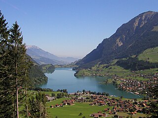
Lungern is a municipality in the canton of Obwalden in Switzerland. It encompasses Lake Lungern and, besides the village of Lungern, the settlements of Bürglen, Kaiserstuhl and Obsee.

Brienzer Rothorn Mountain of the Emmental Alps

The Brienzer Rothorn is a mountain of the Emmental Alps, in Switzerland. With an elevation of 2,350 metres above sea level, the Brienzer Rothorn is the highest summit of the range. To its west lies the Tannhorn, whilst to its east are Arnihaaggen, Höch Gumme and the Brünig Pass. On its south side it overlooks Lake Brienz, whilst to the north it looks out over the Waldemme valley.

Brünig railway line Narrow gauge railway line in Switzerland

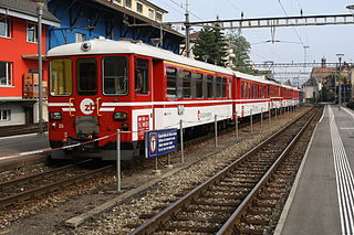
The Brünig railway line is a Swiss narrow gauge railway line that links Lucerne, in central Switzerland, with Interlaken, in the Bernese Oberland. The line runs via Alpnachstad, Giswil, Meiringen and Brienz, and passes over the Brünig Pass, using sections of rack railway to overcome the gradients, but with most of the line operated by normal adhesion methods.

The Sachseln Tunnel is a tunnel in the Swiss canton of Obwalden. It runs to the south-east of the Lake of Sarnen between Giswil and Sarnen, bypassing the old road along the lake side, and forms part of the A8 motorway. The tunnel was completed in 1997 and is 5,231 metres (17,162 ft) long.

The Lopper Road Tunnel is a tunnel in central Switzerland. The tunnel connects Hergiswil in the canton of Nidwalden with Alpnach in the canton of Obwalden, and forms part of the A8 motorway. The tunnel was opened in 1984, and is 1,590 metres (5,220 ft) long. The tunnel has two lanes, and there is no central reservation. The tunnel runs under the Lopper, a shoulder of Mount Pilatus which extends into Lake Lucerne.

Zentralbahn

The Zentralbahn is a Swiss railway company that owns and operates two connecting railway lines in Central Switzerland and the Bernese Oberland. It was created on January 1, 2005, with the acquisition of the independently owned Luzern–Stans–Engelberg line, and the Brünig line of the Swiss Federal Railways. The company has its headquarters in Stansstad.

Lake Sarnen

Lake Sarnen is a lake in the Swiss canton of Obwalden. The lake is on the Sarner Aa, which flows out of the Lake Lungern, through the Lake Sarnen, and into Lake Lucerne. The municipalities of Sarnen and Sachseln are located on the shores of the lake, and the Brünig railway line follows the eastern shore.

Sarner Aa

The Sarner Aa is a 28 km (17 mi) long river in the Swiss canton of Obwalden. It drains the area to the eastern side of the Brünig Pass, flowing through the Lake Lungern, Lake Sarnen and the Wichelsee, before entering Lake Lucerne near Alpnach. It goes by several names over its length, being known as the Lauibach upstream of the Lungerersee, and the Aa or Aawasser between the Lungerersee and Lake Sarnen.

Brünig Pass Mountain pass which connects the Bernese Oberland and central Switzerland

The Brünig Pass, at an altitude of 1,008 m (3,307 ft), connects the Bernese Oberland and central Switzerland, linking Meiringen in the canton of Bern and Lungern in the canton of Obwalden. It is on the watershed between the upper reaches of the Aare, which flows through Lake Brienz and Lake Thun, and the Sarner Aa, which flows into Lake Lucerne.

Höch Gumme

The Höch Gumme is a mountain of the Emmental Alps in Switzerland. It lies to the east of the Brienzer Rothorn and Arnihaaggen, and the west of the Wilerhorn and Brünig Pass. The Schönbüel cable car station is on its eastern flank.

Sarnen railway station

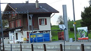
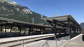
Sarnen railway station is a Swiss railway station on the Brünig line, owned by the Zentralbahn, that links Lucerne and Interlaken. The station is in the municipality of Sarnen in the canton of Obwalden.

Kaiserstuhl OW railway station

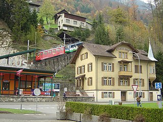
Kaiserstuhl OW railway station is a Swiss railway station on the Brünig line, owned by the Zentralbahn, that links Interlaken and Lucerne. The station is located by the hamlet of Kaiserstuhl, in the municipality of Lungern and the canton of Obwalden.

Alpnach Dorf railway station

Alpnach Dorf railway station is a Swiss railway station in the municipality of Alpnach in the canton of Obwalden. It is on the Brünig line, owned by the Zentralbahn, that links Lucerne and Interlaken.

Hergiswil railway station

Hergiswil railway station is a Swiss railway station in the municipality of Hergiswil in the canton of Nidwalden. It is at the junction of the Brünig line, which links Lucerne and Interlaken, and the Luzern–Stans–Engelberg line. Both lines are of metre gauge and owned by the Zentralbahn railway company. To the south of the station the Brünig line enters the Lopper I tunnel to Alpnach whilst the Luzern–Stans–Engelberg line enters the Lopper II tunnel to Stansstad.

Sachseln railway station

Sachseln railway station is a Swiss railway station on the Brünig line, owned by the Zentralbahn, that links Lucerne and Interlaken. The station is in the municipality of Sachseln in the canton of Obwalden.

The Lopper I Rail Tunnel is a railway tunnel in central Switzerland. The tunnel connects Hergiswil in the canton of Nidwalden with Alpnach in the canton of Obwalden. It forms part of the Zentralbahn Brünig line, which links Lucerne with Interlaken and the Bernese Oberland, between Hergiswil station and Alpnachstad station. It is 1,186 metres (3,891 ft) in length, and carries metre gauge track electrified at 11 kV AC 16 2/3 Hz using overhead catenary. The tunnel runs under the Lopper, a shoulder of Mount Pilatus which extends into Lake Lucerne.

Wilerhorn (Emmental Alps)

The Wilerhorn is a mountain of the Bernese Oberland in Switzerland. It lies to the south-east of the Höch Gumme and to the north-west of the Brünig Pass. It should not be confused with the Wilerhorn that is in the Bernese Alps but the canton of Valais.

References

Coordinates: 46°54′56″N8°16′01″E / 46.915604°N 8.267041°E / 46.915604; 8.267041