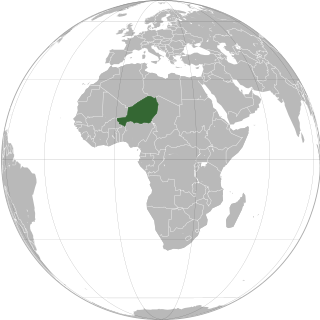
Niger or the Niger, officially the Republic of the Niger, is a landlocked country in West Africa. It is a unitary state bordered by Libya to the northeast, Chad to the east, Nigeria to the south, Benin and Burkina Faso to the southwest, Mali to the west, and Algeria to the northwest. It covers a land area of almost 1,270,000 km2 (490,000 sq mi), making it the largest landlocked country in West Africa and the second largest landlocked nation in Africa behind Chad. Over 80% of its land area lies in the Sahara. Its predominantly Muslim population of about 25 million lives mostly in clusters in the south and west of the country. The capital Niamey is located in Niger's southwest corner.
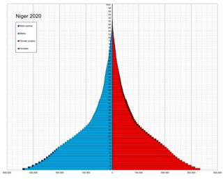
Demographic features of Nigeriens, the people of Niger, include population density, ethnicity, education level, health of the populace, economic status, religious affiliations and other aspects of the population.

Niamey is the capital and largest city of Niger. Niamey lies on the Niger River, primarily situated on the east bank. Niamey's population was counted as 1,026,848 as of the 2012 census. As of 2017, population projections show the capital district growing at a slower rate than the country as a whole, which has the world's highest fertility rate. The city is located in a pearl millet growing region, while manufacturing industries include bricks, ceramic goods, cement, and weaving.

The regions of Niger are subdivided into 63 departments. Before the devolution program on 1999–2005, these departments were styled arrondissements. Confusingly, the next level up (regions) had, before 2002-2005 been styled departments. Prior to a revision in 2011, there had been 36 departments. A draft law in August 2011 would expand that number to 63. Until 2010, arrondissements remained a proposed subdivision of departments, though none were used. The decentralisation process, begun in the 1995-1999 period replaced appointed Prefects at Departmental or Arrondissement level with elected councils, first elected in 1999. These were the first local elections held in the history of Niger. Officials elected at commune level are then selected as representatives at Departmental, regional, and National level councils and administration. The Ministry of Decentralisation was created to oversee this task, and to create a national consultative council of local officials.

Dosso is a city in the south-west corner of Niger. It lies 130–140 kilometres (81–87 mi) south-east of the capital Niamey at the junction of the main routes to Zinder and Benin. The eighth-most populous town in Niger and the largest in Dosso Region, it had an official population during the 2001 census of 43,561. The population grew to 58,671 in the 2012 census. It is the capital of its region - which covers five departments in the southwestern corner of the nation - as well as of its own department, Dosso Department. The city itself lies at the centre of its own Urban Commune.
Tillabéri is a town in northwest Niger. It is situated 113 km northwest of the capital Niamey on the River Niger. It is an important market town and administrative center, being the capital of department of Tillabéri and Tillabéri Region. The town had a population of over 47,678 at the 2012 census.

Tahoua is one of eight Regions of Niger. The capital of the region is the commune of Tahoua. The region covers 106,677 km².
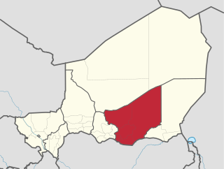
Zinder Region is one of the seven regions of Niger; the capital of the region is Zinder. The region covers 145,430 km². It is the most populous province of Niger.

Abalak is a town located in the Tahoua Region, Abalak Department of northern Niger. It is both a town and Commune: a local administrative division. It is the seat (Chef-lieu) of Abalak Department, one of eight subdivisions of Tahoua Region. The town had a population of less than 74,719 at the 2012 census.
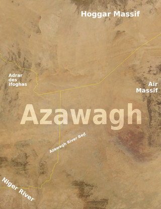
The Azawagh is a dry basin covering what is today the northwestern Niger, as well as parts of northeastern Mali and southern Algeria. The Azawagh is mainly made up of Sahelian and Saharan flatlands and has a population that is predominantly Tuareg, with some Arabic-speaking and Wodaabe minorities and a recent influx of Hausa and Zarma.

Aguie is a town and capital of the Aguie Department in southern Niger, 69 kilometres east of the nation's second largest city, Maradi.
The following outline is provided as an overview of and topical guide to Niger:
Niger is divided into seven regions, each of which is named after its capital. Additionally, the national capital, Niamey, comprises a capital district.
Akoubounou, or Akabinu in the local Tin Sert language, is a village located in the west to the town of Abalak, in the Tahoua Region of Niger.
Tetserret is a Western Berber language spoken by the Ait-Awari and Kel Eghlal Tuareg tribes of the Akoubounou (Akabinu) commune in Niger. This main speech area is located between Abalak, Akoubounou and Shadwanka. The variant spoken by the Kel Eghlal is called taməsəɣlalt. The Tamasheq equivalent shin-sart / shin-sar / tin-sar is used in some older literature. Popular understanding among some Ait-Awari derives the name tet-serret, and its Tamasheq equivalent shin-sart, from expressions meaning 'the (language) of Sirte'.
Affala is a village and rural commune in Niger. It is in the Department of Tahoua. As of 2012, it had a population of 68,225.
Tamou is a village and "Rural commune" in Niger. The town is capital of its Rural Commune in the Say Department of Tillabéri Region, in the far southwest of the nation. It is southwest of Niamey, on the right (western) bank of the Niger River, between the departmental capital Say and the border of Burkina Faso. Tamou Commune is home to the Tamou Total Reserve, a wildlife reserve which is part of the larger W National Park and Transborder Reserve. The Tamou Reserve, in which local people also live, is primarily dedicated to the protection of African Elephant populations which migrate through the region.

Tassara is a village and rural commune in Niger.

Abalak is a rural locality and the administrative center of Abalkskoye Rural Settlement of Tobolsky District, Tyumen Oblast, Russia. The population was 806 as of 2010. There are 20 streets.
