The regions of Niger are subdivided into 63 departments. Before the devolution program on 1999–2005, these departments were styled arrondissements. Confusingly, the next level up (regions) had, before 2002-2005 been styled departments. Prior to a revision in 2011, there had been 36 departments. Until 2010, arrondissements remained a proposed subdivision of departments, though none were used. The decentralisation process, begun in the 1995-1999 period replaced appointed Prefects at Departmental or Arrondissement level with elected councils, first elected in 1999. These were the first local elections held in the history of Niger. Officials elected at commune level are then selected as representatives at Departmental, regional, and National level councils and administration. The Ministry of Decentralisation was created to oversee this task, and to create a national consultative council of local officials.

Mopti is the fifth administrative region of Mali, covering 79,017 km2. Its capital is the city of Mopti. During the 2012 Northern Mali conflict, the frontier between Southern Mali which is controlled by the central government and the rebel-held North ran through Mopti Region.

Bandiagara is a small town and urban commune in the Mopti Region of Mali. The name translates roughly to "large eating bowl"—referring to the communal bowl meals are served in. Mainly on its Bandiagara Escarpment it has about 2,000 speakers of the vibrant Bangime language, an isolate used mainly as an anti-language; it has the highest point of the country.

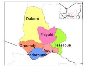
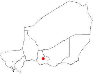
The Region of Maradi is one of seven regions of Niger. It is located in south-central Niger, east of the Region of Tahoua, west of Zinder, and north of the Nigerian city of Katsina. The administrative centre is at Maradi. The population of the Region is predominantly Hausa.

Tessaoua, formerly known as Tessawa, is a city located in the Maradi Region of Niger. It has a population of 43,409. Tessaoua is historically an important city in its region. It is situated in a central geographical location. Tessaoua is a midpoint on a historical trade route between Agadez, Niger, in the north and Kano, Nigeria, in the south. During the collapse of the sultanates of Bornu and Sokoto during the late 19th century, the local ruler declared his territory the sultanate of Tessaoua; he signed a treaty of protection with the French captain Cazemajou in 1897, prior to the explorer's murder in nearby Zinder.
Mayahi is a town located in the Maradi Region of Niger. It is the seat of Mayahi Department and a Commune about 45 km from Tessaoua. In 2012 it had a population of 14,000 in the urban area. The name "Mayaki" is also a rulers' title among the Sudié and Maouri: local subgroups of the Hausa people.
Jikata is a town in Aguie Department, Maradi Region, Niger. Lying almost halfway between Aguie and Tessaoua, the town is well off the major autoroute running between the two cities.
The Departments of Niger are subdivided into communes. As of 2005, in the seven Regions and one Capital Area, there were 36 départements, divided into 265 communes, 122 cantons and 81 groupements. The latter two categories cover all areas not covered by Urban Communes or Rural Communes, and are governed by the Department, whereas Communes have elected councils and mayors. Additional semi-autonomous sub-divisions include Sultanates, Provinces and Tribes (tribus). The Nigerien government estimates there are an additional 17000 Villages administered by Rural Communes, while there are over 100 Quartiers administered by Urban Communes.

Aguie is a town and capital of the Aguie Department in southern Niger, 69 kilometres east of the nation's second largest city, Maradi.
Niger is divided into seven regions, each of which is named after its capital. Additionally, the national capital, Niamey, comprises a capital district.

Dogondoutchi is a department of the Dosso Region in Niger. Its capital lies at the city of Dogondoutchi. As of 2012, the department had a total population of 372,473 people.

Dakoro is a department of the Maradi Region in Niger. Its capital lies at the city of Dakoro. As of 2012, the department had a total population of 630,421 people.
Groumdji is a department of the Maradi Region of Niger. Its capital lies at the city of Guidan Roumdji. As of 2012, the department had a total population of 523,717 people.
Madarounfa is a department of the Maradi Region in Niger. Its capital is Madarounfa. As of 2012, the department had a total population of 448,863 people.
Mayahi Department is a department of the Maradi Region in Niger. Its capital lies at the city of Mayahi. In the mid-1990s, the Department had a population of 125,000, with 2,200 in Mayahi town. As of 2012, the department had a total population of 557,186 people.

Matameye is a department of the Zinder Region in Niger. Its capital lies at the city of Matameye. The chief town lies 72 km from Magaria. It also includes the town of Kantché. As of 2012, the department had a total population of 399,181 people.
Dourou (Dúrù) is a village and rural commune in the Bandiagara Cercle of the Mopti Region of Mali. The commune contains 28 villages along the Bandiagara Escarpment which together at the time of the 2009 census had a population of 19,411. Around 95 percent of the population is Dogon with the remainder being Fulani.
Sangha is a rural commune in the Cercle of Bandigara in the Mopti Region of Mali. The commune contains around 44 small villages and in the 2009 census had a population of 32,513. The administrative centre (chef-lieu) is the village of Sangha Ogol Leye, one of a cluster of at least 10 small villages at the top of the Bandiagara Escarpment.
Dioungani is a village and commune of the Cercle of Koro in the Mopti Region of Mali. Jamsay Dogon is spoken in the commune.

Tibiri is a town and urban commune in Niger. As of 2012, it had a population of 125,806. It is the seat of the Sultan of Gobir.