
Zinder, formerly also spelled Sinder, is the third largest city in Niger, with a population of 235,605 as by the 2012 census. It is situated 861 km (535 mi) east of the capital Niamey and 240 km (150 mi) north of the Nigerian city of Kano.

The regions of Niger are subdivided into 63 departments. Before the devolution program on 1999–2005, these departments were styled arrondissements. Confusingly, the next level up (regions) had, before 2002-2005 been styled departments. Prior to a revision in 2011, there had been 36 departments. Until 2010, arrondissements remained a proposed subdivision of departments, though none were used. The decentralisation process, begun in the 1995-1999 period replaced appointed Prefects at Departmental or Arrondissement level with elected councils, first elected in 1999. These were the first local elections held in the history of Niger. Officials elected at commune level are then selected as representatives at Departmental, regional, and National level councils and administration. The Ministry of Decentralisation was created to oversee this task, and to create a national consultative council of local officials.
Birni-N'Konni is a town in the Tahoua Region of Niger, lying immediately north of the border of Nigeria and west of seasonal Maggia River. It is an important market town and transport hub and as of the 2012 census had a population of 63,169. The town is the historic centre of the small pre-colonial Hausa state of Konni. The name comes from the Hausa for "Walled Town of Konni", and many Hausa towns designate the old citadel neighbourhood the "Birni".

Maradi is the second largest city in Niger and the administrative centre of Maradi Region. It is also the seat of the Maradi Department and an Urban Commune.

Agadez Region is one of the seven regions of Niger. At 667,799 square kilometres (257,839 sq mi), it covers more than half of Niger's land area, and is the largest region in the country, as well as the largest African state subdivision. The capital of the department is Agadez.
Zinder Region is one of the seven regions of Niger; the capital of the region is Zinder. The region covers 145,430 km². It is the most populous province of Niger.

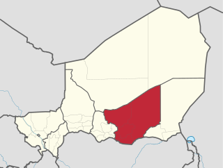
The Region of Maradi is one of seven regions of Niger. It is located in south-central Niger, east of the Region of Tahoua, west of Zinder, and north of the Nigerian city of Katsina. The administrative centre is at Maradi. The population of the Region is predominantly Hausa.

Madaoua is a town and urban commune located in the Tahoua Region of Niger. It has a population of 127,254. It is seat of the Madaoua Department, forming the southwest corner of the Region, and is an Urban Commune.
Mayahi is a town located in the Maradi Region of Niger. It is the seat of Mayahi Department and a Commune about 45 km from Tessaoua. In 2012 it had a population of 14,000 in the urban area. The name "Mayaki" is also a rulers' title among the Sudié and Maouri: local subgroups of the Hausa people.

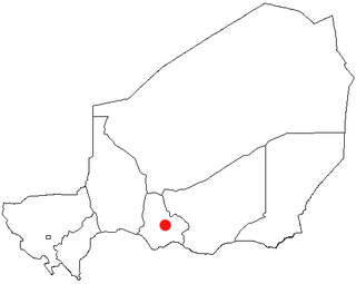
Aguie is a town and capital of the Aguie Department in southern Niger, 69 kilometres east of the nation's second largest city, Maradi.

Abdou Moumouni University, formerly the University of Niamey from 1974 to 1994, is a public university based in Niamey, the capital of Niger. The main campus is situated on the right bank of the Niger River. Historically, its students and faculty have been involved in protest movements in the capital.
The following outline is provided as an overview of and topical guide to Niger:
Niger is divided into seven regions, each of which is named after its capital. Additionally, the national capital, Niamey, comprises a capital district.

Aguie is a department of the Maradi Region in Niger. Its capital lies at the city of Aguie.

The Sultanate of Damagaram was a Muslim pre-colonial state in what is now southeastern Niger, centered on the city of Zinder.

Niger is governed through a four layer, semi-decentralised series of administrative divisions. Begun 1992, and finally approved with the formation of the Fifth Republic of Niger on 18 July 1999, Niger has been enacting a plan for decentralisation of some state powers to local bodies. Prior to the 1999-2006 project, Niger's subdivisions were administered via direct appointment from the central government in Niamey. Beginning with Niger's first municipal elections of 2 February 1999, the nation started electing local officials for the first time. Citizens now elect local committee representatives in each commune, chosen by subdivisions of the commune: "quarters" in towns and "villages" in rural areas, with additional groupings for traditional polities and nomadic populations. These officials choose mayors, and from them are drawn representatives to the department level. The departmental council, prefect, and representatives to the regional level are chosen here using the same procedure. The system is repeated a regional level, with a regional prefect, council, and representatives to the High Council of Territorial Collectives. The HCCT has only advisory powers, but its members have some financial, planning, educational and environmental powers. The central government oversees this process through the office of the Minister of State for the Interior, Public Safety and Decentralization.
Magaria is a town and urban commune in the Magaria Department of the Zinder Region of Niger.

Tibiri is a town and urban commune in Niger. As of 2012, it had a population of 125,806. It is the seat of the Sultan of Gobir.
Marius-Gabriel Cazemajou was a French officer who died during an expedition in West Africa.
The 2018 Coupe nationale du Niger is the 43rd edition of the Coupe nationale du Niger, the knockout football competition of Niger.

