
The regions of Niger are subdivided into 63 departments. Before the devolution program on 1999–2005, these departments were styled arrondissements. Confusingly, the next level up (regions) had, before 2002-2005 been styled departments. Prior to a revision in 2011, there had been 36 departments. A draft law in August 2011 would expand that number to 63. Until 2010, arrondissements remained a proposed subdivision of departments, though none were used. The decentralisation process, begun in the 1995-1999 period replaced appointed Prefects at Departmental or Arrondissement level with elected councils, first elected in 1999. These were the first local elections held in the history of Niger. Officials elected at commune level are then selected as representatives at Departmental, regional, and National level councils and administration. The Ministry of Decentralisation was created to oversee this task, and to create a national consultative council of local officials.

Dosso is a city in the south-west corner of Niger. It lies 130–140 kilometres (81–87 mi) south-east of the capital Niamey at the junction of the main routes to Zinder and Benin. The eighth-most populous town in Niger and the largest in Dosso Region, it had an official population during the 2001 census of 43,561. The population grew to 58,671 in the 2012 census. It is the capital of its region - which covers five departments in the southwestern corner of the nation - as well as of its own department, Dosso Department. The city itself lies at the centre of its own Urban Commune.
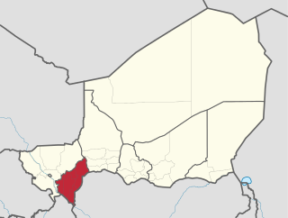
Dosso is one of the eight Regions of Niger. The region has an area of 31,002 square kilometres (11,970 sq mi), with a population of 2,078,339 as of 2011.
The Departments of Niger are subdivided into communes. As of 2005, in the seven Regions and one Capital Area, there were 36 départements, divided into 265 communes, 122 cantons and 81 groupements. The latter two categories cover all areas not covered by Urban Communes or Rural Communes, and are governed by the Department, whereas Communes have elected councils and mayors. Additional semi-autonomous sub-divisions include Sultanates, Provinces and Tribes (tribus). The Nigerien government estimates there are an additional 17000 Villages administered by Rural Communes, while there are over 100 Quartiers administered by Urban Communes.
Loga is a town and an urban commune in Niger. As of 2012, it had a population of 82,400.

Tibiri is a town and urban commune in Niger. As of 2012, it had a population of 125,806. It is the seat of the Sultan of Gobir.
Dakoussa is a village and rural commune in the Takeita Department of the Zinder Region of Niger. As of 2012, it had a population of 61,779.
Dioundiou is a village and rural commune in the Dioundiou Department of the Dosso Region of Niger. As of 2012, it had a population of 54,157.
Falmey is a village and rural commune in the Falmey Department of the Dosso Region of Niger. As of 2012, it had a population of 75,115.
Gaffati is a village and rural commune in the Mirriah Department of the Zinder Region of Niger. As of 2012, it had a population of 46,379.
Garagoumsa is a village and rural commune in the Takeita Department of the Zinder Region of Niger. As of 2012, it had a population of 69,028.
Golle, Niger is a village and rural commune in Niger. As of 2012, it had a population of 27,860.
Gouchi is a village and rural commune in the Dungass Department of the Zinder Region of Niger. As of 2012, it had a population of 71,612.
Hamdara is a village and rural commune in the Guidimouni Department of the Zinder Region of Niger. As of 2012, it had a population of 39,574.

Harikanassou is a large village and rural commune in the Boboye Department of the Dosso Region of southwest Niger, 90.7 kilometres (56.4 mi) by road southeast of the capital of Niamey. At the time of the 2012 census, the rural community had 23,567 residents living in 3,340 households. Onion cultivation is a chief source of income for many, along with the cultivation of lettuce, beans, squashes, and tomatoes.
Kieche is a village and rural commune in Niger. As of 2012, it had a population of 48,980.

Kiota is a small town and rural commune in Niger in the Boboye Department, Dosso Region. As of 2012, it had a population of 25,282.
It is the seat of the most important Tijaniyyah community in Niger.
The weekly market is on Fridays.
Kwaya, Niger is a village and rural commune in the Magaria Department of the Zinder Region of Niger. As of 2012, it had a population of 32,510.
Malawa, Niger is a village and rural commune in the Dungass Department of the Zinder Region of Niger. As of 2012, it had a population of 88,954.
Sassoumbroum is a village and rural commune in the Magaria Department of the Zinder Region of Niger. As of 2012, it had a population of 78,163.