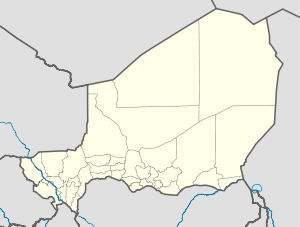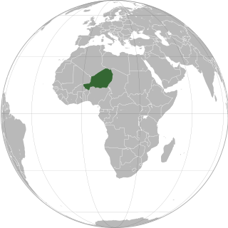
Niger or the Niger, officially the Republic of the Niger, is a country in West Africa. It is a unitary state bordered by Libya to the northeast, Chad to the east, Nigeria to the south, Benin and Burkina Faso to the southwest, Mali to the west, and Algeria to the northwest. It covers a land area of almost 1,270,000 km2 (490,000 sq mi), making it the largest landlocked country in West Africa and the second largest landlocked nation in Africa behind Chad. Over 80% of its land area lies in the Sahara. Its predominantly Muslim population of about 25 million lives mostly in clusters in the south and west of the country. The capital Niamey is located in Niger's southwest corner.

Ségou is a town and an urban commune in south-central Mali that lies 235 kilometres (146 mi) northeast of Bamako on the right bank of the River Niger. The town is the capital of the Ségou Cercle and the Ségou Region. With 130,690 inhabitants in 2009, it is the fifth-largest town in Mali.

Agadez Region is one of the seven regions of Niger. At 667,799 square kilometres (257,839 sq mi), it covers more than half of Niger's land area, and is the largest region in the country, as well as the largest African state subdivision. The capital of the department is Agadez.

Kouroussa is a prefecture located in the Kankan Region of Guinea. The capital is Kouroussa. The prefecture covers an area of 14,050 km.² and has a population of 268,630. With Kouroussa town by far the largest in the Prefecture numbering only 10,000, the vast majority of the Prefecture's population live in small rural communities, making their living from subsistence and small scale cash crop agriculture, as well as small scale trade and mining. The majority of the population are members of the Malinke ethnic group or related Mande speakers. The eastern portion of the prefecture is formed from the Niger River valley, while most of the area characterized by low rolling hills and dry savanna grasslands or scrub-like forest.

Dongondoutchi is a commune in Niger. It is located about 300 km east of the capital Niamey and 40 km from the Nigerian border. It lies on national route 1 which links the capital to the towns of Maradi and Zinder to the east and the RN25 heading to north to Tahoua, Agadez and Arlit.
Goundam is a commune and town in north central Mali, in the Tombouctou Region. It is the capital of Goundam Cercle, one of five subdivisions of the Region. In the 2009 census the commune had a population of 16,253. The main ethnic groups are Songhay, Tuareg and Fulani.
In-Gall is a department, commune and town in the Agadez Region of northeast Niger, with a year-round population of less than 500. Known for its oasis and salt flats, In-Gall is the gathering point for the Cure Salee festival of Tuareg and Wodaabe pastoralists to celebrate the end of the rainy season each September. During the festival, In-Gall's population grows to several thousand nomads, officials, and tourists. As of 2011, the commune had a total population of 47,170 people.
Bouza is a town in southwestern Niger. A town of eight thousand, it is the administrative center of Bouza Department, part of Tahoua Region.
Bani-Bangou is a town in southwestern Niger, in rural northern Ouallam Department, Tillabéri Region. It is the capital of the rural commune of Bani-Bangou. On the main highway from Ouallam on the route to the Malian border town of Andéramboukane. It is 135 km northeast of Ouallam and 70 km by road from Mali. It around 200 km cross country from Niamey. The town is the seat of a "Rural Commune" of the same name, one of four rural communes in the department. Nearby villages include Gorou, Bassikwana, and Tondi Tiyaro Kwara to the north; Koloukta and Dinara along the highway west; Ouyé to the southeast.

Goure is a Commune and town in southeastern Niger, Zinder Region, Goure Department, of which it is the seat. As of 2012, it had a population of 73,732.
Dabaga is a town and rural commune in the Agadez Region of northern Niger. The town is situated around 50 kilometers north of the regional capital, Agadez, on the main road leading north into the Aïr Mountains and the town of Elmeki. Like the nearby communities of Azel, Elmeki and Egandawel, Dabaga is an oasis in the Aïr Massif valleys, populated by both sedentary and semi-nomadic Tuaregs and small numbers of Hausa and other groups. According to the census 2012, Dabaga had a permanent population of 23,969, mostly families of Tuareg pastoralists, where the adult males traveled with their herds.

Bouza is a department of the Tahoua Region in Niger. Its capital lies at the city of Bouza, and also includes the town of Déoulé. As of 2012, the department had a total population of 445,363 people.

Say is a department of the Tillabéri Region in Niger. Its capital city is Say, and includes the towns of Guéladjo, Tamou, and Torodi. It abuts the urban Region of Niamey, and lies across the Niger River to the southwest of the capital. It extends to the Burkina Faso border over 60 km to the west, and the northernmost border with Benin in the south. The Say area is today divided between the riverine valley in the east of the Department, and the more sparsely populated areas to the west, which are intercut with a series of eastward flowing tributaries. The Niger river, a broad shallow channel at Niamey and at Say, passes through a series of gorges and cataracts, called the "W" bend for the shape the river takes, in the south of the Say Department. To the west of these rapids lies what is now the W Regional Park, a sparsely populated area historically plagued by insect borne diseases of both humans and cattle. Now a park and tourist attraction, its history as a "no mans land" has made it a refuge for remaining wild animals, as well as several undisturbed archeological sites. From at least the 16th century CE, the Songhai proper moved south into this area from the north around what is now Tera. The inhabitants at the time were related to the Gourma people, who form most of the population of the northwestern part of the Department today. In the 18th and 19th century, the town of Say was founded by Fulani migrants from the Gao region of modern Mali, with others expanding from what is now northeast Burkina Faso. Between 1810 and the arrival of European writer Heinrich Barth in 1854, Fulani Muslims led by Alfa Mohamed Diobo of Djenné had established the Emirate of Say. The reputation for piety and learning of Mohamed Diobo and his followers helped turn Say from a small river village into a town of 30,000, famed across West Africa as a center of learning.
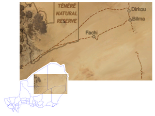
Dirkou is a town in the Bilma Department, Agadez Region of north-eastern Niger. It lies in the northern Kaouar escarpment, a north–south line of cliffs which form an isolated oasis in the Sahara desert. As of 2011, the commune had a total population of 14,998 people. Apart from the main city of Dirkou, the rural communities of Achénouma, Aney, and Emi Tchouma lie within the borders of the commune.

Niger is governed through a four layer, semi-decentralised series of administrative divisions. Begun 1992, and finally approved with the formation of the Fifth Republic of Niger on 18 July 1999, Niger has been enacting a plan for decentralisation of some state powers to local bodies. Prior to the 1999-2006 project, Niger's subdivisions were administered via direct appointment from the central government in Niamey. Beginning with Niger's first municipal elections of 2 February 1999, the nation started electing local officials for the first time. Citizens now elect local committee representatives in each commune, chosen by subdivisions of the commune: "quarters" in towns and "villages" in rural areas, with additional groupings for traditional polities and nomadic populations. These officials choose mayors, and from them are drawn representatives to the department level. The departmental council, prefect, and representatives to the regional level are chosen here using the same procedure. The system is repeated a regional level, with a regional prefect, council, and representatives to the High Council of Territorial Collectives. The HCCT has only advisory powers, but its members have some financial, planning, educational and environmental powers. The central government oversees this process through the office of the Minister of State for the Interior, Public Safety and Decentralization.

Spinophorosaurus is a genus of sauropod dinosaur that lived in what is now Niger during the Middle Jurassic period. The first two specimens were excavated in the 2000s by German and Spanish teams under difficult conditions. The skeletons were brought to Europe and digitally replicated, making Spinophorosaurus the first sauropod to have its skeleton 3D printed, and were to be returned to Niger in the future. Together, the two specimens represented most of the skeleton of the genus, and one of the most completely known basal sauropods of its time and place. The first skeleton was made the holotype specimen of the new genus and species Spinophorosaurus nigerensis in 2009; the generic name refers to what was initially thought to be spiked osteoderms, and the specific name refers to where it was found. A juvenile sauropod from the same area was later assigned to the genus.
Bankilaré is a village and rural commune in Niger. Bankilaré commune, centered on the town of the same name, is in Téra Department, Tillabéri Region, in the northwestern corner of the country. The town lies 60 km north of Departmental capital Téra, and around the same distance from the Burkina Faso border and the Mali border. As of 2012, it had a population of 84,893.
Tarka, Niger is a village and rural commune in Niger. It is located in the Belbédji Departement of the Zinder Region. As of 2012 the commune had a population of 96,452.

Tassara is a village and rural commune in Niger.

Torodi is a small town and a rural commune in Niger. As of 2012, it had a population of 109,342. As a rural center, Torodi hosts a large weekly market and the seat of local tribal authority (canton). Torodi is in the Say Department of the Tillaberi Region, which surrounds the national capital, Niamey. Say Department, with its capital at the large Niger River town of Say, abuts Niamey to the southwest and across the river to the west. The town of Torodi lies about 60 km due west of the city of Say and 50 km east of the border with Burkina Faso. Torodi itself lies on a tributary of the Niger, the Gourbi river.