Zinder, formerly also spelled Sinder, is the third largest city in Niger, with a population of 235,605 as by the 2012 census. It is situated 861 km (535 mi) east of the capital Niamey and 240 km (150 mi) north of the Nigerian city of Kano.

The regions of Niger are subdivided into 63 departments. Before the devolution program on 1999–2005, these departments were styled arrondissements. Confusingly, the next level up (regions) had, before 2002-2005 been styled departments. Prior to a revision in 2011, there had been 36 departments. Until 2010, arrondissements remained a proposed subdivision of departments, though none were used. The decentralisation process, begun in the 1995-1999 period replaced appointed Prefects at Departmental or Arrondissement level with elected councils, first elected in 1999. These were the first local elections held in the history of Niger. Officials elected at commune level are then selected as representatives at Departmental, regional, and National level councils and administration. The Ministry of Decentralisation was created to oversee this task, and to create a national consultative council of local officials.

Maradi is the second largest city in Niger and the administrative centre of Maradi Region. It is also the seat of the Maradi Department and an Urban Commune.
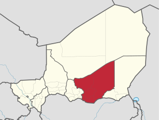
Zinder Region is one of the seven regions of Niger; the capital of the region is Zinder. The region covers 145,430 km². It is the most populous province of Niger.

Dakoro is a town and commune located in the Maradi Region of Niger. As of 2012, it had a population of 71,201. It is the capital of the Dakoro Department.
The Departments of Niger are subdivided into communes. As of 2005, in the seven Regions and one Capital Area, there were 36 départements, divided into 265 communes, 122 cantons and 81 groupements. The latter two categories cover all areas not covered by Urban Communes or Rural Communes, and are governed by the Department, whereas Communes have elected councils and mayors. Additional semi-autonomous sub-divisions include Sultanates, Provinces and Tribes (tribus). The Nigerien government estimates there are an additional 17000 Villages administered by Rural Communes, while there are over 100 Quartiers administered by Urban Communes.
Niger is divided into seven regions, each of which is named after its capital. Additionally, the national capital, Niamey, comprises a capital district.

The Sultanate of Damagaram was a Muslim pre-colonial state in what is now southeastern Niger, centered on the city of Zinder.

Niger is governed through a four layer, semi-decentralised series of administrative divisions. Begun 1992, and finally approved with the formation of the Fifth Republic of Niger on 18 July 1999, Niger has been enacting a plan for decentralisation of some state powers to local bodies. Prior to the 1999-2006 project, Niger's subdivisions were administered via direct appointment from the central government in Niamey. Beginning with Niger's first municipal elections of 2 February 1999, the nation started electing local officials for the first time. Citizens now elect local committee representatives in each commune, chosen by subdivisions of the commune: "quarters" in towns and "villages" in rural areas, with additional groupings for traditional polities and nomadic populations. These officials choose mayors, and from them are drawn representatives to the department level. The departmental council, prefect, and representatives to the regional level are chosen here using the same procedure. The system is repeated a regional level, with a regional prefect, council, and representatives to the High Council of Territorial Collectives. The HCCT has only advisory powers, but its members have some financial, planning, educational and environmental powers. The central government oversees this process through the office of the Minister of State for the Interior, Public Safety and Decentralization.
Illela, Niger is a town and urban commune in Niger.
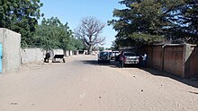
Mirriah is a town and urban commune in Niger.

Tibiri is a town and urban commune in Niger. As of 2012, it had a population of 125,806. It is the seat of the Sultan of Gobir.
Bande, Niger is a village and rural commune in the Magaria Department of the Zinder Region of Niger.
Dantchiao is a village and rural commune in the Magaria Department of the Zinder Region of Niger. As of 2012, it had a population of 71,018.
Sassoumbroum is a village and rural commune in the Magaria Department of the Zinder Region of Niger. As of 2012, it had a population of 78,163.
Tarka, Niger is a village and rural commune in Niger. It is located in the Belbédji Departement of the Zinder Region. As of 2012 the commune had a population of 96,452.
Yaouri is a village and rural commune in Matameye Department in Niger.
Ahmadu Dan Tanimu, known as Ahmadu Kuran Daga or Ahmadu Mai Rinji was the Sultan of the Sultanate of Damagaram from 1893 to 1899. His reign marked the height of Damagaram's military and political prowess. He inherited thousands of muskets and dozens of canons from his father, along with canon factories and ammunition plants. Ahmadu soon found himself in a power struggle with the Emirate of Kano under Aliyu Mai Sango, Bornu under Rabih Az-Zubayr, and French Colonialists. After the assassination of French officer Marius Gabriel Cazemajou and his interpreter in Zinder under Ahmadu's orders, he was subdued and killed by the French in retaliation.

The Songhai, ) is an area in the northwestern corner of Niger's Tillabéri Region populated mainly by the Songhaiborai. It is considered the heartland of the Songhai people and the sanctuary of their ancient pantheon and priestly class and the place in which the original lineage of the Sonni dynasty retreated after the coup d'etat of 1493 creating a secret society of magicians, the Sohance.
The Union des Femmes du Niger (UFN) was a women's organisation in Niger, which was active from 1959 to 1974 and was affiliated to the Nigerien Progressive Party. It advocated, with limited success, for increases in women's rights.