Abbotsbury, New South Wales

Last updated

Abbotsbury
Sydney,  New South Wales
Western Sydney parklands 21.jpg
View of Abbotsbury from Western Sydney Parklands
Abbotsbury, New South Wales
Map
Population4,253 (2021 census) [1]
 • Density3,270/km2 (8,500/sq mi)
Postcode(s) 2176
Elevation61 m (200 ft)
Area1.3 km2 (0.5 sq mi)
Location39 km (24 mi) west of Sydney CBD
LGA(s) City of Fairfield
State electorate(s)
Federal division(s)
Suburbs around Abbotsbury:
Horsley Park Horsley Park Bossley Park
Cecil Park Abbotsbury Edensor Park
Cecil Hills Cecil Park Bonnyrigg Heights

Abbotsbury is a suburb of Sydney, New South Wales, Australia 39 kilometres west of the Sydney central business district in the local government area of the City of Fairfield. Abbotsbury is part of the Greater Western Sydney region.

Contents

Most of the suburb's estates were built in the late 1980s and early 1990s, although a few acres of undeveloped land in the north-west area was subdivided and developed in the early 2010s. The western border of the suburb is delineated by a line of pine trees, which gives privacy to the homes backing onto the farmlands.

History

Abbotsbury was named from Major Edward Abbott, a Canadian-born soldier who arrived in New South Wales in 1790. Abbott was granted land in what is now Abbotsbury in 1806 although sold it to William Browne in 1810. The estate remained intact until the late 19th century when it was subdivided into small farms and it remained a rural area until the late 20th century when residential subdivision began. The name for the suburb was approved in 1984. [2] [3] [4]

Demographics

According to the 2021 census, there were 4,200 residents in Abbotsbury. 61.0% of residents were born in Australia. The most common countries of birth were Iraq 9.3%, Italy 3.4%, Vietnam 3.0%, Philippines 1.5% and Croatia 1.5%.

The most common ancestries were Italian 23.0%, Australian 14.4%, English 9.0%, Assyrian 7.5% and Croatian 6.6%.

50.4% of people only spoke English at home. Other languages spoken at home included Assyrian Neo-Aramaic 6.5%, Italian 5.8%, Arabic 5.1%, Chaldean Neo-Aramaic 5.0% and Vietnamese 3.9%.

The most common responses for religion were Catholic 53.2%, No Religion 8.8%, Eastern Orthodox 7.2%, Islam 4.5% and Assyrian Church of the East 4.2%. Overall, Christianity was the largest religious group reported overall (79.7%). [1]

Landmarks

Abbotsbury is best known for Calmsley Hill Farm, which is located on the western side of the suburb. [5]

In the north-west of the suburb lies the Western Sydney Parklands, which sits on a hilly ridge. On these large hills there are a few recreational spots, such as Moonrise Lookout and Sugarloaf Ridge. They are both adjacent to each other and would feature a panoramic view of all of Sydney, where the city skyline may be seen from there. Families enjoy to picnic and walk in these area, and even come here to view the new years fireworks from Sydney Harbour.

Commercial area

The suburb has a small shopping complex, including a grocery store, a vet, a hairdressers, a barber, a cafe and a small Italian restaurant. Abbotsbury's telephone and internet runs off the Edensor Park Exchange. iiNet's and TPG's ADSL2+ service as well as general ADSL, Cable and NBN are available in the area.

Abbotsbury is also one of the safest suburbs in Western Sydney, due to the fact that the only entrance is on the east.[ citation needed ] The north and west of Abbotsbury leads to a national park and there are no roads here although there are a number of firetrails.

Transport

Abbotsbury is serviced by the region three bus operator Transit Systems. The 808 and 806 buses come through here. The most common form of transport used by residents is private vehicle.

Sport and recreation

The Western Sydney cycling path passes through Abbotsbury. Stretching far along Western Sydney, the cycling path passes through the Calmsley Hill City Farm (previously known as Fairfield City Farm), which is located at the Western Sydney Regional Park. Calmsley Hill City Farm was used during the 2000 Sydney Olympics for the mountain biking events. [6] The biking tracks remain. [7]

The suburb also has a sporting field named Stockdale Reserve. It is mainly used for soccer cricket and rugby league, depending on the time of year. Adjacent to this park, there are several ponds, home to many species of birds, mainly ducks. Within the Reserve is a shared pathway for pedestrians and cyclists.

Housing

In 2015, the median sale price of houses in the area was $1,198,750. Abbotsbury contains some large properties on the outskirts, some blocks reaching sizes over half of an acre, which is rare to find in the suburbs of Sydney. Withers Place, located in the north of Abbotsbury, is the most expensive and affluent with a median price of $2,700,000. [8]

Climate

Abbotsbury has a humid subtropical climate (Cfa) with warm to hot summers and cool winters. Much of the precipitation is observed in the first four months of the year, with the middle of the year recording lesser rainfall in comparison.

Climate data for Horsley Park (Sydney International Equestrian Centre)
MonthJanFebMarAprMayJunJulAugSepOctNovDecYear
Record high °C (°F)47.0
(116.6)
46.4
(115.5)
40.5
(104.9)
35.9
(96.6)
28.1
(82.6)
24.7
(76.5)
27.3
(81.1)
28.4
(83.1)
36.0
(96.8)
37.5
(99.5)
42.0
(107.6)
44.4
(111.9)
47.0
(116.6)
Mean daily maximum °C (°F)30.0
(86.0)
28.6
(83.5)
26.7
(80.1)
23.9
(75.0)
20.6
(69.1)
17.6
(63.7)
17.4
(63.3)
19.1
(66.4)
22.4
(72.3)
24.8
(76.6)
26.4
(79.5)
28.4
(83.1)
23.8
(74.8)
Mean daily minimum °C (°F)18.0
(64.4)
17.8
(64.0)
16.1
(61.0)
12.9
(55.2)
9.1
(48.4)
7.2
(45.0)
5.8
(42.4)
6.4
(43.5)
9.3
(48.7)
11.8
(53.2)
14.4
(57.9)
16.2
(61.2)
12.1
(53.8)
Record low °C (°F)10.6
(51.1)
10.4
(50.7)
7.2
(45.0)
1.9
(35.4)
1.0
(33.8)
−1.8
(28.8)
−2.3
(27.9)
−0.5
(31.1)
0.7
(33.3)
3.6
(38.5)
6.6
(43.9)
9.0
(48.2)
−2.3
(27.9)
Average precipitation mm (inches)74.3
(2.93)
124.5
(4.90)
94.5
(3.72)
69.2
(2.72)
44.7
(1.76)
71.3
(2.81)
38.4
(1.51)
39.1
(1.54)
36.4
(1.43)
60.8
(2.39)
78.8
(3.10)
66.2
(2.61)
780.3
(30.72)
Average precipitation days (≥ 1 mm)7.87.68.86.75.26.45.04.04.75.97.27.276.5
Average relative humidity (%)49535453525550424245504849
Source: Bureau of Meteorology [9]

Related Research Articles

<span class="mw-page-title-main">Edensor Park, New South Wales</span> Suburb of Sydney, New South Wales, Australia

Edensor Park is a suburb of Sydney, New South Wales, Australia. Edensor Park is located 38 kilometres west of the Sydney central business district in the local government area of the City of Fairfield. It is mainly a residential area, Edensor Park is part of the Greater Western Sydney region.

<span class="mw-page-title-main">Greater Western Sydney</span> Region in New South Wales, Australia

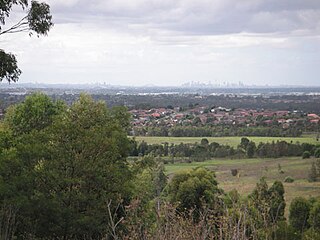
Greater Western Sydney (GWS) is a large region of the metropolitan area of Greater Sydney, New South Wales (NSW), Australia that generally embraces the north-west, south-west, central-west, far western and the Blue Mountains sub-regions within Sydney's metropolitan area and encompasses 13 local government areas: Blacktown, Blue Mountains, Camden, Campbelltown, Canterbury-Bankstown, Cumberland, Fairfield, Hawkesbury, Hills Shire, Liverpool, Parramatta, Penrith and Wollondilly. It includes Western Sydney, which has a number of different definitions, although the one consistently used is the region composed of ten local government authorities, most of which are members of the Western Sydney Regional Organisation of Councils (WSROC). Penrith, Hills Shire & Canterbury-Bankstown are not WSROC members. The NSW Government's Office of Western Sydney calls the region "Greater Western Sydney".

<span class="mw-page-title-main">Fairfield, New South Wales</span> Suburb of Sydney, New South Wales, Australia

Fairfield is a suburb of South Western Sydney, in the state of New South Wales, Australia. Being in the centre of the Cumberland Plain, Fairfield is located 30 kilometres (19 mi) west of the Sydney central business district and is the administrative heart of the Fairfield City Council – despite a very small portion of it belonging to the Cumberland Council. Fairfield supports a mixture of commercial and residential developments, mostly characterised by medium-density buildings and some new high-rise apartments.

<span class="mw-page-title-main">Wetherill Park, New South Wales</span> Suburb of Greater Western Sydney, New South Wales, Australia

Wetherill Park is a suburb in Greater Western Sydney, in the state of New South Wales, Australia. Wetherill Park is located 34 kilometres west of the Sydney central business district, in the local government area of the City of Fairfield.

St Johns Park is a suburb of Sydney, in the state of New South Wales, Australia 35 kilometres west of the Sydney central business district, in the local government areas of the City of Fairfield. It is part of the Greater Western Sydney region.

<span class="mw-page-title-main">Smithfield, New South Wales</span> Suburb of Sydney, New South Wales, Australia

Smithfield is a suburb of Sydney, in the state of New South Wales, Australia. Smithfield is located 31 kilometres (19 mi) west of the Sydney central business district, in the local government areas of the City of Fairfield and Cumberland Council. Located in the Greater Western Sydney region, the suburb is one of the largest in Fairfield City by area.

<span class="mw-page-title-main">Prairiewood, New South Wales</span> Suburb of Sydney, New South Wales, Australia

Prairiewood is a suburb of Sydney, in the state of New South Wales, Australia 34 kilometres west of the Sydney central business district, in the local government area of the City of Fairfield. It is part of the Greater Western Sydney region.

<span class="mw-page-title-main">Bonnyrigg, New South Wales</span> Suburb of Sydney, New South Wales, Australia

Bonnyrigg is a suburb of Sydney, in the state of New South Wales, Australia 36 kilometres west of the Sydney central business district, in the local government area of the City of Fairfield. It is part of the Greater Western Sydney region.

Bonnyrigg Heights is a suburb of Sydney, in New South Wales, Australia. Its name originates from Bonnyrigg, Midlothian, Scotland. Bonnyrigg Heights is located on the traditional indigenous lands of the Dharug Nation.

<span class="mw-page-title-main">Bossley Park</span> Suburb of Sydney, New South Wales, Australia

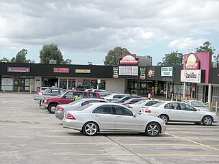
Bossley Park is a suburb of Sydney, in the state of New South Wales, Australia. Bossley Park is located 36 kilometres west of the Sydney central business district in the local government area of the City of Fairfield. Bossley Park is part of the Greater Western Sydney region. The suburb is most well known for being an ethnic enclave of Assyrian and other Iraqi ethnic groups living in Sydney.

Cecil Park is a suburb of Sydney, in the state of New South Wales, Australia 40 kilometres west of the Sydney central business district, in the local government area of the City of Fairfield. It is part of the Greater Western Sydney region.

Fairfield West is a suburb of Sydney, in the state of New South Wales, Australia. Fairfield West is located 27 kilometres west of the Sydney central business district in the local government area of the City of Fairfield. Fairfield West is part of the Greater Western Sydney region.

Fairfield Heights is a suburb of Sydney, in the state of New South Wales, Australia. Fairfield Heights is located 25 kilometres west of the Sydney central business district in the local government area of the City of Fairfield. Fairfield Heights is part of the Greater Western Sydney region.

<span class="mw-page-title-main">Greenfield Park, New South Wales</span> Suburb of Sydney, New South Wales, Australia

Greenfield Park is a suburb of Sydney, in the state of New South Wales, Australia. Greenfield Park is located 36 kilometres west of the Sydney central business district in the local government area of the City of Fairfield. The suburb has one of the most highest proportion of Assyrian people in the Sydney area and Australia per se.

<span class="mw-page-title-main">Horsley Park, New South Wales</span> Suburb of Sydney, New South Wales, Australia

Horsley Park is a suburb of Sydney in the state of New South Wales, Australia. Horsley Park is located 39 kilometres west of the Sydney central business district in the local government area of the City of Fairfield. Horsley Park is part of the Greater Western Sydney region. It is a semi-rural suburb, located 5 km west of Wetherill Park and 11 km north-west of Fairfield.

<span class="mw-page-title-main">Cecil Hills, New South Wales</span> Suburb of Sydney, New South Wales, Australia

Cecil Hills is a suburb of Sydney, in the state of New South Wales, Australia. Cecil Hills is located 38 kilometres west of the Sydney central business district, in the local government area of the City of Liverpool and is part of the Greater Western Sydney region.

<span class="mw-page-title-main">Hinchinbrook, New South Wales</span> Suburb of Sydney, New South Wales, Australia

Hinchinbrook is a suburb of Sydney, in the state of New South Wales, Australia. Hinchinbrook is located 35 kilometres south-west of the Sydney central business district, in the local government area of the City of Liverpool. It is bordered by Hoxton Park and Green Valley.

<span class="mw-page-title-main">Assyrian Australians</span> Ethnic group of Australia

Assyrian Australians, refers to ethnic Assyrians possessing Australian nationality. They are descended from the Northern Mesopotamian region, specifically the Assyrian homeland. Today, their homeland is a part of North Iraq, Southeast Turkey, Northwest Iran and Northeast Syria.

<span class="mw-page-title-main">Division of McMahon</span> Australian federal electoral division

The Division of McMahon is an Australian electoral division in the state of New South Wales.

Elizabeth Hills is a suburb of western Sydney, in the state of New South Wales, Australia. It is located 39 kilometres south-west of the Sydney central business district, in the local government area of Liverpool. Elizabeth Hills was gazetted as a suburb on 18 December 2009. Like the neighbouring suburb of Len Waters Estate, Elizabeth Hills had previously been part of the suburb of Cecil Hills.

References

  1. 1 2 Australian Bureau of Statistics (28 June 2022). "Abbotsbury (State Suburb)". 2021 Census QuickStats. Retrieved 30 November 2021. OOjs UI icon edit-ltr-progressive.svg
  2. "Abbotsbury". Fairfield City Council. Archived from the original on 17 August 2008. Retrieved 12 June 2008.
  3. Abbott, Edward (1766–1832). Australian Dictionary of Biography Online. Retrieved 12 June 2008.
  4. "Abbotsbury". Geographical Names Register (GNR) of NSW. Geographical Names Board of New South Wales . Retrieved 12 June 2008. OOjs UI icon edit-ltr-progressive.svg
  5. "Fairfield City Farm". Fairfield City Council. Archived from the original on 2 August 2008. Retrieved 12 June 2008.
  6. 2000 Summer Olympics official report. Archived 9 November 2000 at the Wayback Machine Volume 1. p. 374.
  7. "Fairfield City Farm: History". Fairfield City Council. Archived from the original on 6 May 2008. Retrieved 12 June 2008.
  8. "Abbotsbury suburb profile". Fairfax. Archived from the original on 15 June 2011. Retrieved 12 June 2008.
  9. "Climate statistics for Horsley Park". Bureau of Meteorology. Retrieved 4 July 2022.

33°52′30″S150°51′43″E / 33.875°S 150.862°E / -33.875; 150.862