The River Eden in West Kent is a tributary of the River Medway. It travels through the Weald of Kent from the border with Surrey, rising from the source in Titsey parish, Surrey, grid reference TQ 420 551, about 350 metres north of Clacket Lane motorway services, and flowing eastward through the Wealden clay to join the River Medway near Penshurst, Kent, grid reference TQ 537 434. The section from its source to where the Gibbs Brook joins it is also known as the Broadmead Water. Its name is a back formation deriving from Edenbridge, the main town through which it flows, and which was originally called in the Old English language "Eadhelmsbrigge".

Westcott is a semi-rural English village and former civil parish 1.5 miles (2.4 km) west of the centre of Dorking on the A25 between the North Downs and Greensand Ridge, making it one of the 'Vale of Holmesdale' villages and is in Surrey in the direction of Guildford. It is served by a local bus service and is 1 mile (1.6 km) from Dorking West railway station on the North Downs Line.

Abinger is a large, well-wooded and mostly rural civil parish that lies between the settlements of Dorking, Shere and Ewhurst in the district of Mole Valley, Surrey, England. It adjoins Wotton Common on the same side of Leith Hill and includes Abinger Hammer, Sutton Abinger, Abinger Common, Forest Green, Walliswood, Oakwood Hill and some outskirts of Holmbury St Mary. More than half of the parish lies on the Greensand Ridge, while the remainder is divided between the Vale of Holmesdale and the North Downs.

Shere is a village in the Guildford district of Surrey, England 4.8 miles (7.7 km) east south-east of Guildford and 5.4 miles (8.7 km) west of Dorking, centrally bypassed by the A25. It is a small still partly agricultural village chiefly set in the wooded 'Vale of Holmesdale' between the North Downs and Greensand Ridge with many traditional English features. It has a central cluster of old village houses, shops including a blacksmith and trekking shop, tea house, art gallery, two pubs and a Norman church. Shere has a CofE infant and nursery school with 'outstanding academic results' catering for 2- to 7-year-old children which serves the village and surrounding villages and towns, and a museum which opens most afternoons at weekends.

Albury is a village and civil parish in the borough of Guildford in Surrey, England, about 4 miles (6.4 km) south-east of Guildford town centre. The village is within the Surrey Hills Area of Outstanding Natural Beauty. Farley Green, Little London and adjacent Brook form part of the civil parish.

Chilworth is a village in the Guildford borough of Surrey, England. It is located in the Tillingbourne valley, southeast of Guildford.
Holmbury St. Mary is a village in Surrey, England centered on shallow upper slopes of the Greensand Ridge. Its developed area is a clustered town 4.5 miles (7 km) southwest of Dorking and 8 miles (13 km) southeast of Guildford. Most of the village is in the borough of Guildford, within Shere civil parish. Much of the east side of the village street is in the district of Mole Valley, within Abinger civil parish.
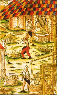
A hammer mill, hammer forge or hammer works was a workshop in the pre-industrial era that was typically used to manufacture semi-finished, wrought iron products or, sometimes, finished agricultural or mining tools, or military weapons. The feature that gave its name to these workshops was the water-driven trip hammer, or set of hammers, used in the process. The shaft, or 'helve', of the hammer was pivoted in the middle and the hammer head was lifted by the action of cams set on a rotating camshaft that periodically depressed the end of the shaft. As it rose and fell, the head of the hammer described an arc. The face of the hammer was made of iron for durability.

Ewhurst is a rural village and civil parish in the borough of Waverley in Surrey, England. It is located 8.3 miles (13.4 km) south-east of Guildford, 2 miles (3.2 km) east of Cranleigh and 4.5 miles (7.2 km) south of Shere.

Lieutenant General William Frederick Scarlett, 3rd Baron Abinger, was a British peer and soldier.

Peaslake, Hoe and Colmar's Hill are in the centre of the Surrey Hills AONB and mid-west of the Greensand Ridge about 5 miles (8.0 km) ESE of the county town of Guildford, England point-to-point. Surrounded by denser pine and other coniferous forest-clad hills, the three conjoined settlements have a small core in Peaslake itself with the amenities of a village but are otherwise lightly scattered settlements at a higher elevation than the centre of Shere, the civil parish.

Gomshall is a village in the borough of Guildford in Surrey, England.

The River Tillingbourne runs along the south side of the North Downs and joins the River Wey at Guildford. Its source is near Tilling Springs to the north of Leith Hill at grid reference TQ143437 and it runs through Friday Street, Abinger Hammer, Gomshall, Shere, Albury, Chilworth and Shalford. The source is a semi-natural uninhabited area. The catchment is situated on sandstone which has a low rate of weathering. The Tillingbourne is 24 km (15 mi) in length.

The Vale of Holmesdale is a comparatively narrow valley lying at the foot of the North Downs in Surrey and Kent, England. It stretches from Folkestone on the Kent coast through Ashford, Harrietsham, Maidstone, Riverhead/Sevenoaks, Oxted, Godstone, Redhill, Reigate, Dorking, Gomshall, Chilworth, Shalford and ending in Guildford.

Tillingbourne Bus Company was a bus company based in Cranleigh, Surrey. The company operated bus and coach services in Surrey, West Sussex, Hampshire and Berkshire from 1924 until 2001.

The Law Brook or Postford Brook is a Surrey stream, a tributary of the Tillingbourne which in turn flows into the River Wey. It is notable in its own right chiefly for its industrial heritage.

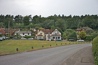
Friday Street is a hamlet on the gentle lower north slope of Leith Hill in Surrey, England. It is in a wooded headwater ravine, just to the south of Wotton and the A25, a single rather than dual carriageway road, running between Guildford to the west and Dorking to the east. It is part of the Surrey Hills AONB.
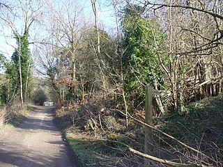
Piney Copse is 1.7 hectares of woodland located approximately 450 metres (1,480 ft) east of Gomshall railway station and north of the Surrey village of Abinger Hammer. The copse is bisected by a public footpath. It was once owned by E. M. Forster, who used to live nearby and purchased the wood using funds from book sales - principally from A Passage to India - in order to prevent it from being developed into housing. When Forster died in 1970, he transferred ownership of the land in his will to the National Trust. In 1926 Forster wrote a short essay about Piney Copse in "Abinger Harvest", entitled "My Wood".

Many watermills lined the banks of the River Wey, England, from the 17th century due to the river's ability to provide a reliable, year-round flow of water. These mills chiefly ground wheat, often referred to as corn, for flour and oats for animal feed though many were used in the production of other goods such as paper, cloth, leather, wire and gunpowder. The river was home to more mills per mile than anywhere else in Great Britain. The mill situated at Coxes Lock near Addlestone, Surrey, is the largest. There are many mills on the river's principal tributaries, such as the Tillingbourne, the Ock and some mills on the Whitmore Vale stream, Cranleigh Waters and Hodge Brook. The last commercial mill on the Tillingbourne, Botting's Mill at Albury, closed in 1990. Headley Water Mill, on the Wey South branch is still in business. Town Mill, Guildford still has a water turbine driven generator producing electricity for the town.