Oxmoor Copse

Last updated
Oxmoor Copse

Oxmoorcopse.jpg

The copse is managed by the Woodland Trust
Geography
Surrey UK location map.svg
Red pog.svg
Location Surrey,England
OS grid TQ097467
Coordinates 51°12′34″N0°25′49″W / 51.2095°N 0.4304°W / 51.2095; -0.4304 Coordinates: 51°12′34″N0°25′49″W / 51.2095°N 0.4304°W / 51.2095; -0.4304
Area 1.23 hectares (3.0 acres)
Governing body Woodland Trust

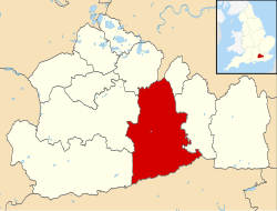
Oxmoor Copse is just south of the village of Abinger Hammer and to the west of the village of Abinger Common, in Surrey. It is 1.23 hectares (3.0 acres) and is in an AONB lying within the Surrey Hills. [1] The previous owners gave the copse to the Woodland Trust as a gift.

Abinger Hammer village in the United Kingdom

Abinger Hammer is a village or small community in a narrow part of the Vale of Holmesdale where it forms the valley of the River Tillingbourne and mainly on the parallel A25 in Surrey, England. Its homes, land and its parent civil parish are in the Surrey Hills AONB. It is approximately midway between the market towns of Dorking and Guildford — Guildford is the county town, just over 6 miles (10 km) west. The village is named after its mill which powered an iron forge.

Surrey County of England

Surrey is a subdivision of the English region of South East England in the United Kingdom. A historic and ceremonial county, Surrey is also one of the home counties. The county borders Kent to the east, East Sussex and West Sussex to the south, Hampshire to the west, Berkshire to the northwest, and Greater London to the northeast.

Area of Outstanding Natural Beauty Designated area of countryside in England, Wales or Northern Ireland

An Area of Outstanding Natural Beauty (AONB) is an area of countryside in England, Wales or Northern Ireland which has been designated for conservation due to its significant landscape value. Areas are designated in recognition of their national importance, by the relevant public body: Natural England, Natural Resources Wales, or the Northern Ireland Environment Agency. In place of AONB, Scotland uses the similar national scenic area (NSA) designation. Areas of Outstanding Natural Beauty enjoy levels of protection from development similar to those of UK national parks, but unlike with national parks the responsible bodies do not have their own planning powers. They also differ from national parks in their more limited opportunities for extensive outdoor recreation.

The copse lies on Greensand and the soil is acidic. The main trees are mature oaks and hazel; there are also bluebells. [2] A considerable number of trees were blown down in the 1987 storm. Replanting took place in 1991. Arable and pastoral land surrounds the copse. On the fringes of the copse there is a considerable amount of Common Cudweed but generally the copse is species poor. [3]

Greensand

Greensand or green sand is a sand or sandstone which has a greenish color. This term is specifically applied to shallow marine sediment, that contains noticeable quantities of rounded greenish grains. These grains are called glauconies and consist of a mixture of mixed-layer clay minerals, such as smectite and glauconite mica. Greensand is also loosely applied to any glauconitic sediment.

Oak genus of plants

An oak is a tree or shrub in the genus Quercus of the beech family, Fagaceae. There are approximately 600 extant species of oaks. The common name "oak" also appears in the names of species in related genera, notably Lithocarpus, as well as in those of unrelated species such as Grevillea robusta and the Casuarinaceae (she-oaks). The genus Quercus is native to the Northern Hemisphere, and includes deciduous and evergreen species extending from cool temperate to tropical latitudes in the Americas, Asia, Europe, and North Africa. North America contains the largest number of oak species, with approximately 90 occurring in the United States, while Mexico has 160 species of which 109 are endemic. The second greatest center of oak diversity is China, which contains approximately 100 species.

Hazel genus of plants

The hazel (Corylus) is a genus of deciduous trees and large shrubs native to the temperate Northern Hemisphere. The genus is usually placed in the birch family Betulaceae, though some botanists split the hazels into a separate family Corylaceae. The fruit of the hazel is the hazelnut.

The grid reference is TQ 090 467

Related Research Articles

River Avon, Devon River in county of Devon, England

The River Avon, also known as the River Aune, is a river in the county of Devon in the south of England. It rises in the southern half of Dartmoor National Park in an area of bog to the west of Ryder's Hill. Close to where the river leaves Dartmoor a dam was built in 1957 to form the Avon reservoir. After leaving the moor it passes through South Brent and then Avonwick and Aveton Gifford and flows into the sea at Bigbury-on-Sea. Near Loddiswell the valley flows through Fosse Copse a 1.88 hectares woodland owned and managed by the Woodland Trust.

Borthwood Copse

Borthwood Copse, near Sandown, Isle of Wight, England is a piece of woodland owned by the National Trust and is one of the numerous copses which make up part of the medieval forest which covered most of the eastern end of the Island. Borthwood Copse sits on the outskirts of Newchurch, and is close to the neighbouring hamlet of Apse Heath and the villages of Queen's Bower and Alverstone. Borthwood Copse was originally a royal hunting ground. It was bequeathed to the National Trust in 1926 by Frank Morey. He had purchased it a few years earlier to preserve it for wildlife. Subsequent additions have added to the land and it now covers a total of 60 acres (240,000 m2).

Whittlewood Forest forest in the county of Northamptonshire in England

Whittlewood Forest is a former medieval hunting forest east of Silverstone in Northamptonshire in England. It is managed by the Woodland Trust.There are tracts of ancient woodland within the forest, and old ditch boundaries can be found at the edges of several of the individual woods. The area has been the subject of extensive academic historical research. An area of 400 hectares in seven different patches has been designated a biological Site of Special Scientific Interest (SSSI). It is a Nature Conservation Review site, Grade 2.

Yattendon village in the United Kingdom

Yattendon is a geographically small village and civil parish 7 miles (11 km) northeast of Newbury, Berkshire. The M4 motorway passes through the fields of the village which lie 0.5 miles (800 m) south and below the elevations of its cluster.

Bookham Commons

Bookham Commons are two commons, situated just to the north of the villages of Great Bookham and Little Bookham, in Surrey, England, 154.7 hectares in extent; the individual parts are named Great Bookham Common and Little Bookham Common. A group of dwellings known as the Isle of Wight is situated within the site, and a track, Common Road, leads to it from the northwest. Little Bookham Common lies south and west of this track, whereas Great Bookham Common lies to the east.

Goddards country house in Surrey, England

Goddards is a large country house in Abinger Common, Surrey, England.

Chiddingfold Forest

Chiddingfold Forest is a 542.5-hectare (1,341-acre) biological Site of Special Scientific Interest in Chiddingfold in Surrey and West Sussex. One part of it, Fir Tree Copse, is a nature reserve which is managed by the Surrey Wildlife Trust

Vann Lake and Ockley Woods

Vann Lake and Ockley Woods is a 57.8-hectare (143-acre) biological Site of Special Scientific Interest south of Ockley in Surrey. Vann Lake is part of Vann Lake and Candy's Copse, a nature reserve managed by the Surrey Wildlife Trust.

Ramsnest Common village in United Kingdom

Ramsnest Common is a hamlet in the far south of the Borough of Waverley, the largest district of Surrey, England centred on the A283 1.5 miles (2.4 km) SSW of Chiddingfold village centre between Milford and Petworth in West Sussex which it borders. The area of overwhelmingly rural land, most of which is scattered forest, in particular Killinghurst Great Copse, had no medieval settlement.

Trodds Copse

Trodds Copse is a 25.23 hectare biological Site of Special Scientific Interest (SSSI), in central Hampshire, notified in 1989. It comprises ancient semi-natural woodland, unimproved meadows and flushes.

Briddlesford Nature Reserve consists of 158 hectares of land on the Isle of Wight that is composed of a complex of different habitats, including woodland, arable farmland, lowland meadow, parkland, pond, hedgerow and grazing marsh. The reserve encompasses a majority of the Briddlesford Copses Site of Special Scientific Interest (SSSI) and Special Area of Conservation (SAC) together with about 50 hectares of farmland. The reserve is owned by People's Trust for Endangered Species (PTES) and managed to preserve and enhance its biodiversity value.

Piney Copse

Piney Copse is 1.7 hectares of woodland located approximately 450 metres (1,480 ft) east of Gomshall railway station and north of the Surrey village of Abinger Hammer. The copse is bisected by a public footpath. It was once owned by E. M. Forster, who used to live nearby and purchased the wood using funds from book sales - principally from A Passage to India - in order to prevent it from being developed into housing. When Forster died in 1970, he transferred ownership of the land in his will to the National Trust. In 1926 Forster wrote a short essay about Piney Copse in "Abinger Harvest", entitled "My Wood".

Edolphs Copse

Edolph's Copse is a 27.6-hectare (68-acre) Local Nature Reserve west of Horley in Surrey. It is owned and managed by the Woodland Trust.

Kitchen Copse

Kitchen Copse is a 7-hectare (17-acre) nature reserve north of Bletchingley in Surrey. It is managed by the Surrey Wildlife Trust.

Fir Tree Copse

Fir Tree Copse is a 6-hectare (15-acre) nature reserve south-east of Dunsfold in Surrey. It is managed by the Surrey Wildlife Trust and is part of the Chiddingfold Forest Site of Special Scientific Interest

Pucks Oak Barn and McAlmont Reserves

Pucks Oak Barn and McAlmont Reserves is a 4-hectare (9.9-acre) nature reserve near Compton, west of Guildford in Surrey. It is managed by the Surrey Wildlife Trust.

Wotton and Abinger Commons

Wotton and Abinger Commons is a 324-hectare (800-acre) nature reserve south-west of Dorking in Surrey. It is managed by the Surrey Wildlife Trust. Part of it is in Leith Hill Site of Special Scientific Interest

References