Netherside Stream Outcrops

Last updated
Netherside Stream Outcrops
Site of Special Scientific Interest
Netherside Stream Outcrops 2.jpg
Area of Search Surrey
Grid reference SU 942 341 [1]
InterestGeological
Area2.9 hectares (7.2 acres) [1]
Notification 1992 [1]
Location map Magic Map

Netherside Stream Outcrops is a 2.9-hectare (7.2-acre) geological Site of Special Scientific Interest north-east of Haslemere in Surrey. [1] [2] It is a Geological Conservation Review site. [3]

Site of Special Scientific Interest Conservation designation denoting a protected area in the United Kingdom

A Site of Special Scientific Interest (SSSI) in Great Britain or an Area of Special Scientific Interest (ASSI) in the Isle of Man and Northern Ireland is a conservation designation denoting a protected area in the United Kingdom and Isle of Man. SSSI/ASSIs are the basic building block of site-based nature conservation legislation and most other legal nature/geological conservation designations in the United Kingdom are based upon them, including national nature reserves, Ramsar sites, Special Protection Areas, and Special Areas of Conservation. The acronym "SSSI" is often pronounced "triple-S I".

Haslemere town in Surrey, England

Haslemere is a town in the borough of Waverley in Surrey, England. It is north-east of the tripoint with Hampshire and West Sussex, approximately 12 miles (19 km) southwest of Guildford, and is the most southerly town in Surrey. The town is in the upper Wey valley and east of the A3, the major road between London and Portsmouth.

Surrey County of England

Surrey is a subdivision of the English region of South East England in the United Kingdom. A historic and ceremonial county, Surrey is also one of the home counties. The county borders Kent to the east, East Sussex and West Sussex to the south, Hampshire to the west, Berkshire to the northwest, and Greater London to the northeast.

This is the Type locality for the Netherside Sand Member of the Weald Clay Group, dating to the Lower Cretaceous around 130 million years ago. Upward sloping sandstone has fossil Lycopodites plants in vertical life positions. [4]

Type locality, also called type area, or type section, is the locality where a particular rock type, stratigraphic unit or mineral species is first identified. If the stratigraphic unit in a locality is layered, it is called a stratotype, whereas the standard of reference for unlayered rocks is the type locality.

Lycopodiopsida class of plants

Lycopodiopsida is a class of herbaceous vascular plants known as the clubmosses and firmosses. They have dichotomously branching stems bearing simple leaves called microphylls and reproduce by means of spores borne in sporangia at the bases of the leaves. Traditionally, the group also included the spikemosses and the quillworts but because these groups have leaves with ligules and reproduce using spores of two different sizes, both are now placed into another class, Isoetopsida that also includes the extinct Lepidodendrales. These groups, together with the horsetails are often referred to informally as fern allies.

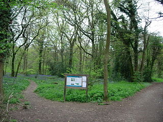
A public footpath runs through the site.

Related Research Articles

Windsor Forest and Great Park

Windsor Forest and Great Park is a 1,778.9-hectare (4,396-acre) biological Site of Special Scientific Interest in Berkshire and Surrey, located south of Windsor. It is a Special Area of Conservation and Windsor Forest is a Nature Conservation Review site, Grade I. Landscaped woodland gardens are Grade I listed on the Register of Historic Parks and Gardens of Special Historic Interest. Windsor Great Park is a Royal Park of 2,020 hectares, including a deer park,

Ash to Brookwood Heaths

Ash to Brookwood Heaths is a 1,576.3-hectare (3,895-acre) biological Site of Special Scientific Interest west of Guildford in Surrey. It is a Nature Conservation Review site, Grade I. It is part of the Thames Basin Heaths Special Protection Area and the Thursley, Ash, Pirbright and Chobham Special Area of Conservation. An area of 1,392 hectares is managed as a nature reserve by the Surrey Wildlife Trust.

Auclaye

Auclaye is a 0.6-hectare (1.5-acre) geological Site of Special Scientific Interest south of Capel in Surrey. It is a Geological Conservation Review site.

Brook Brick Pit

Brook Brick Pit is a 0.9-hectare (2.2-acre) geological Site of Special Scientific Interest west of Wormley Surrey. It is a Geological Conservation Review site.

Clock House Brickworks

Clock House Brickworks is a 35.9-hectare (89-acre) geological Site of Special Scientific Interest south of Capel in Surrey. It is a Geological Conservation Review site.

Colony Bog and Bagshot Heath

Colony Bog and Bagshot Heath is a 1,130.5-hectare (2,794-acre) biological Site of Special Scientific Interest between Camberley and Woking in Surrey. Part of it is a Nature Conservation Review site, Grade I. It is part of the Thames Basin Heaths Special Protection Area and the Thursley, Ash, Pirbright and Chobham Special Area of Conservation. It includes Brentmoor Heath, a Local Nature Reserve which is managed by the Surrey Wildlife Trust

Colyers Hanger

Colyers Hanger is a 26.6-hectare (66-acre) biological Site of Special Scientific Interest south-east of Guildford in Surrey. It is a Nature Conservation Review site, Grade 2 and is part of St Martha's Hill and Colyer's Hanger nature reserve, which is managed by the Surrey Wildlife Trust.

Glovers Wood

Glover's Wood is a 74.5-hectare (184-acre) biological Site of Special Scientific Interest east of Charlwood in Surrey. It is a Nature Conservation Review site, Grade 2.

Hackhurst and White Downs

Hackhurst and White Downs is a 185.1-hectare (457-acre) biological Site of Special Scientific Interest west of Dorking in Surrey. White Downs is a Nature Conservation Review site, Grade 2, and part of it is in the 200-hectare (490-acre) White Downs nature reserve, which is owned by the Wotton Estate and managed by the Surrey Wildlife Trust (SWT). Hackhurst Downs is a 29.9-hectare (74-acre) Local Nature Reserve, which part of the 40-hectare (99-acre) Hackhurst Downs nature reserve, which is owned by Surrey County Council and also managed by the SWT.

Mole Gap to Reigate Escarpment

Mole Gap to Reigate Escarpment is a 1,016.4-hectare (2,512-acre) biological and geological Site of Special Scientific Interest west of Reigate in Surrey. It is a Geological Conservation Review site and a Special Area of Conservation. Part of it is a Nature Conservation Review site, Grade I. Two small private nature reserves in the site are managed by the Surrey Wildlife Trust, Dawcombe and Fraser Down.

Seale Chalk Pit

Seale Chalk Pit is a 1.2-hectare (3.0-acre) geological Site of Special Scientific Interest west of Guildford in Surrey. It is a Geological Conservation Review site and part of the Seale Chalk Pit and Meadow 3-hectare (7.4-acre) private nature reserve, which is managed by the Surrey Wildlife Trust.

Sheepleas

Sheepleas is a 99.9-hectare (247-acre) biological and geological Site of Special Scientific Interest east of Guildford in Surrey. It is a Geological Conservation Review site and a Local Nature Reserve. It is owned by Surrey County Council and managed by the Surrey Wildlife Trust.

Smokejack Clay Pit

Smokejack Clay Pit is a 56-hectare (140-acre) geological Site of Special Scientific Interest east of Cranleigh in Surrey. It is a Geological Conservation Review site.

Staffhurst Wood

Staffhurst Wood is a 51-hectare (130-acre) biological Site of Special Scientific Interest south of Oxted in Surrey. It is a Nature Conservation Review site, Grade 2. An area of 38.1 hectares is a Local Nature Reserve, which is owned by Surrey County Council and managed by the Surrey Wildlife Trust.

Stockstone Quarry

Stockstone Quarry is a 3.9-hectare (9.6-acre) geological Site of Special Scientific Interest south of Farnham in Surrey. It is a Geological Conservation Review site.

Upper Common Pits

Upper Common Pits is a 3-hectare (7.4-acre) geological Site of Special Scientific Interest north of Gomshall in Surrey. It is a Geological Conservation Review site.

Dryhill Nature Reserve

Dryhill is an 11.7-hectare (29-acre) geological Site of Special Scientific Interest on the western outskirts of Sevenoaks in Kent. It is a Geological Conservation Review site, and an area of 9.5 hectares is a Local Nature Reserve

Thursley, Hankley and Frensham Commons

Thursley, Hankley and Frensham Commons is a 1,878.5-hectare (4,642-acre) biological Site of Special Scientific Interest west of Godalming in Surrey. Thursley and Hankley Commons are Nature Conservation Review sites, Grade I. An area of 115.1 hectares is a Local Nature Reserve called The Flashes and an area of 180 hectares is the Elstead Group of Commons, a nature reserve managed by the Surrey Wildlife Trust. Thursley Common is a National Nature Reserve. An area of 265.7 hectares is the Thursley & Ockley Bogs Ramsar site. The site is a Special Protection Area and part of the Thursley, Ash, Pirbright & Chobham Special Area of Conservation.

Slinfold Stream and Quarry Site of Special Scientific Interest

Slinfold Stream and Quarry is a 2.3-hectare (5.7-acre) geological Site of Special Scientific Interest west of Horsham in West Sussex. It is a Geological Conservation Review site.

References

  1. 1 2 3 4 "Designated Sites View: Netherside Stream Outcrops". Sites of Special Scientific Interest. Natural England. Retrieved 11 November 2018.
  2. "Map of Netherside Stream Outcrops". Sites of Special Scientific Interest. Natural England. Retrieved 11 November 2018.
  3. "Chiddingfold (Wealden)". Geological Conservation Review. Joint Nature Conservation Committee. Retrieved 28 October 2018.
  4. "Netherside Stream Outcrop citation" (PDF). Sites of Special Scientific Interest. Natural England. Retrieved 11 November 2018.

Coordinates: 51°05′53″N0°39′22″W / 51.098°N 0.656°W / 51.098; -0.656

Geographic coordinate system Coordinate system

A geographic coordinate system is a coordinate system that enables every location on Earth to be specified by a set of numbers, letters or symbols. The coordinates are often chosen such that one of the numbers represents a vertical position and two or three of the numbers represent a horizontal position; alternatively, a geographic position may be expressed in a combined three-dimensional Cartesian vector. A common choice of coordinates is latitude, longitude and elevation. To specify a location on a plane requires a map projection.