
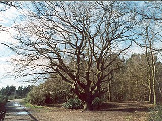
Chobham Common is a 655.7-hectare (1,620-acre) biological Site of Special Scientific Interest north of Chobham in Surrey. It is a Nature Conservation Review site, Grade I and a National Nature Reserve. It is part of the Thames Basin Heaths Special Protection Area and the Thursley, Ash, Pirbright and Chobham Special Area of Conservation. It contains three Scheduled Monuments. Most of the site is managed by the Surrey Wildlife Trust as the Chobham Common nature reserve, but the SSSI also includes a small private reserve managed by the Trust, Gracious Pond.

Surrey is a county in South East England. It has an area of 642 square miles and an estimated population of 1.1 million as of 2017. It is bordered by Greater London, Kent, East Sussex, West Sussex, Hampshire and Berkshire. Its top level of government is provided by Surrey County Council and the lower level by eleven boroughs and districts, Elmbridge, Epsom and Ewell, Guildford, Mole Valley, Reigate and Banstead, Runnymede, Spelthorne, Surrey Heath, Tandridge, Waverley and Woking.

Hankley Common is a 560-hectare (1,400-acre) nature reserve south-west of Elstead in Surrey. It is owned by the Ministry of Defence and managed by the Surrey Wildlife Trust. The site is part of the Thursley, Hankley and Frensham Commons Special Area of Conservation, Special Protection Area and Site of Special Scientific Interest.

The River Bourne is the name given to a Thames tributary in northwest Surrey, England which has a longer tributary, the Windle Brook, that rises nears Bagshot Park in the south of Swinley Forest, Berkshire, merging with it while flowing through villages north of Woking; downstream the Bourne joins the Thames near Weybridge.

Ash to Brookwood Heaths is a 1,576.3-hectare (3,895-acre) biological Site of Special Scientific Interest west of Guildford in Surrey. It is a Nature Conservation Review site, Grade I. It is part of the Thames Basin Heaths Special Protection Area and the Thursley, Ash, Pirbright and Chobham Special Area of Conservation. An area of 1,392 hectares is managed as a nature reserve by the Surrey Wildlife Trust.

Broadmoor to Bagshot Woods and Heaths is a 1,696.3-hectare (4,192-acre) biological Site of Special Scientific Interest in Berkshire and Surrey. The area extends from much of the parish of Crowthorne including around Broadmoor Hospital in the west to Bagshot south-east, Bracknell north-east, and Sandhurst, south. It is part of the Thames Basin Heaths Special Protection Area and an area of 498 hectares is the Barossa nature reserve, which is managed by the Surrey Wildlife Trust.

Dersingham Bog is a 159.1-hectare (393-acre) biological and geological Site of Special Scientific Interest Norfolk. It is a Nature Conservation Review site, Grade 2, a National Nature Reserve and a Ramsar site It is part of the Norfolk Coast Area of Outstanding Natural Beauty, and the Roydon Common & Dersingham Bog Special Area of Conservation Part of it is a Geological Conservation Review site.
Esher Commons is a 360.1-hectare (890-acre) biological Site of Special Scientific Interest south-west of Esher in Surrey. It includes Esher Common, Fairmile Common, West End Common and Oxshott Heath. Esher Common and West End Common are Local Nature Reserves.

Ockham and Wisley Commons is a 266-hectare (660-acre) biological Site of Special Scientific Interest east of Woking in Surrey. It is also a Local Nature Reserve and part of the Thames Basin Heaths Special Protection Area. It is part of the slightly larger area of 297-hectare (730-acre) Wisley & Ockham Commons & Chatley Heath nature reserve, which is owned by Surrey County Council and managed by the Surrey Wildlife Trust.
The Thames Basin Heaths are a natural region in southern England in the counties of Berkshire, Hampshire and Surrey.
Thursley, Hankley and Frensham Commons is a 1,878.5-hectare (4,642-acre) biological Site of Special Scientific Interest west of Godalming in Surrey. Thursley and Hankley Commons are Nature Conservation Review sites, Grade I. An area of 115.1 hectares is a Local Nature Reserve called The Flashes and an area of 180 hectares is the Elstead Group of Commons, a nature reserve managed by the Surrey Wildlife Trust. Thursley Common is a National Nature Reserve. An area of 265.7 hectares is the Thursley & Ockley Bogs Ramsar site. The site is a Special Protection Area and part of the Thursley, Ash, Pirbright & Chobham Special Area of Conservation.

Bisley and West End Commons is a 37.2-hectare (92-acre) Local Nature Reserve west of Woking in Surrey. It is part of the 46-hectare (110-acre) Bisley & West End Commons and Reidon Hill nature reserve, which is owned by Surrey County Council and managed by Surrey Wildlife Trust. The site is also part of the Colony Bog and Bagshot Heath Site of Special Scientific Interest, the Thursley, Ash, Pirbright & Chobham Special Area of Conservation and the Thames Basin Heaths Special Protection Area,

Brentmoor Heath is a 28.6-hectare (71-acre) Local Nature Reserve east of Camberley in Surrey. It is part of Brentmoor Heath and Folly Bog nature reserve, the ownership of which is divided between the Ministry of Defence, Surrey County Council and Surrey Heath Borough Council, and is managed by Surrey Wildlife Trust. The site is also part of Colony Bog and Bagshot Heath site of Special Scientific Interest, Thursley, Ash, Pirbright & Chobham Special Area of Conservation and Thames Basin Heaths Special Protection Area.

The Flashes is a 115.1-hectare (284-acre) Local Nature Reserve west of Godalming in Surrey. It is owned by the National Trust and managed by Waverley Borough Council. It is part of Thursley, Hankley and Frensham Commons Sites of Special Scientific Interest, Thursley, Ash, Pirbright & Chobham Special Area of Conservation and Thursley, Hankley & Frensham Commons Special Protection Area,
Ash Ranges is a 1,392-hectare (3,440-acre) nature reserve west of Pirbright in Surrey. It is owned by the Ministry of Defence and managed by the Surrey Wildlife Trust. It is part of the Thames Basin Heaths Special Protection Area and the Ash to Brookwood Heaths Site of Special Scientific Interest
Barossa is a 498-hectare (1,230-acre) nature reserve north of Camberley in Surrey. It is owned by the Ministry of Defence and managed by the Surrey Wildlife Trust. It is part of the Thames Basin Heaths Special Protection Area and the Broadmoor to Bagshot Woods and Heaths Site of Special Scientific Interest

Elstead Group of Commons is a 180-hectare (440-acre) nature reserve east of Elstead in Surrey. It is composed of Royal, Elstead and Ockley Commons, which are owned by the Ministry of Defence and managed by the Surrey Wildlife Trust, and Bagmoor Common, which is owned and managed by the Trust. The site is part of Thursley, Hankley and Frensham Commons Special Protection Area and Site of Special Scientific Interest.

Poors Allotment is a 76-hectare (190-acre) nature reserve north of Camberley in Surrey. It is owned by Windlesham United Charities and managed by the Surrey Wildlife Trust. It is part of Thames Basin Heaths Special Protection Area and Broadmoor to Bagshot Woods and Heaths Site of Special Scientific Interest.


