Wraysbury is a village and civil parish in the Royal Borough of Windsor and Maidenhead in England. It is under the western approach path of London Heathrow Airport. It is located on the east bank of the River Thames, roughly midway between Windsor and Staines-upon-Thames, and 18 miles (29 km) west by south-west of London. Historically part of Buckinghamshire, Wraysbury was made part of the new non-metropolitan county of Berkshire in 1974, under the Local Government Act 1972. The Wraysbury Reservoir is located to the east, administratively wholly in the Spelthorne district of Surrey, although it was historically divided between Buckinghamshire and Middlesex.
Abberton Reservoir is a pumped storage freshwater reservoir in eastern England near the Essex coast, with an area of 700 hectares. Most of its water is pumped from the River Stour. It is the largest body of freshwater in Essex.

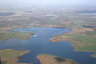
The Staines Reservoirs are two large pumped storage reservoirs sitting to the east of the King George VI Reservoir near Heathrow airport in Surrey within the Colne Valley regional park. The village of Stanwell is mainly to the north east, and the town of Staines is to the south.
The Queen Mother Reservoir is a public water supply reservoir that lies between the M4 and the M25 to the west of London, close to Datchet. It is 475 acres (1.92 km2) in size or about 1 km in diameter - making it one of the largest inland areas of water in Southern England. It is managed by Thames Water.

The Knight Reservoir is a large pumped storage reservoir located in the Borough of Elmbridge in Surrey. It was inaugurated in 1907 and stores up to 2,180 million litres of raw water abstracted from the River Thames prior to its treatment and supply to London and north Surrey. It is located south of the River Thames, west of West Molesey, and between Hurst Road (A3050) and Walton Road (B369). It is adjacent to, and west of, its twin Bessborough Reservoir.

The Lee Valley Reservoir Chain is located in the Lee Valley, and comprises 13 reservoirs that supply drinking water to London.

Lockwood Reservoir is located in Walthamstow in the London Borough of Waltham Forest. It is one of the ten Walthamstow Reservoirs, which are part of the Lee Valley Reservoir Chain. The reservoirs supply drinking water to London and are owned by Thames Water.

The King George VI Reservoir sits between Stanwell Moor and Staines upon Thames, south-west of Heathrow, England. It is between Staines Moor and a north–south road abutting the Staines Reservoirs. The reservoir was opened in November 1947 and named after the then reigning monarch George VI. It is owned by Thames Water.

Kempton Park Reservoirs are a Site of Special Scientific Interest in the London Borough of Hounslow and Kempton Park in Surrey. It is owned by Thames Water. It is part of South West London Waterbodies Ramsar site and Special Protection Area Kempton Park East reservoir is also a local nature reserve.

Staines Moor is a 510.8-hectare (1,262-acre) biological Site of Special Scientific Interest north of Staines-upon-Thames in Surrey. It is part of the South West London Waterbodies Ramsar site and a Special Protection Area

Gladhouse Reservoir, formerly known as Moorfoot Loch, is a reservoir in Midlothian, Scotland, five miles (8 km) south of Penicuik. It is the most southerly reservoir in Midlothian, as well as being the largest area of freshwater in the Lothians. It is used to supply Edinburgh with drinking water.
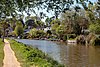
The Colne Brook is a river in England that is a distributary of the River Colne which runs from Uxbridge Moor, there forming the western border of Greater London, to the River Thames just below Bell Weir Lock in Hythe End, Wraysbury, Berkshire.

Wraysbury No 1 Gravel Pit is a 58.0-hectare (143-acre) biological Site of Special Scientific Interest in Wraysbury in Berkshire. It is part of South West London Waterbodies Ramsar site, and Special Protection Area. The lake has an area of 39.6 hectares. The pit was excavated in the 1920s and 1930s with gravel being removed from the site. Over the years plants and wildlife have colonised the area and it is now mature.

Wraysbury and Hythe End Gravel Pits is a 117.2-hectare (290-acre) biological Site of Special Scientific Interest in Wraysbury in Berkshire. It is part of South West London Waterbodies Ramsar site and Special Protection Area.

South Thames Estuary and Marshes is a 5,289-hectare (13,070-acre) biological Site of Special Scientific Interest which stretches between Gravesend and the mouth of the River Medway in Kent. Part of it is a Nature Conservation Review site, Grade I, and part is a Royal Society for the Protection of Birds nature reserve. It is part of the Thames Estuary and Marshes Ramsar internationally important wetland site and Special Protection Area under the European Union Directive on the Conservation of Wild Birds.
Knight and Bessborough Reservoirs is a 63.4-hectare (157-acre) biological Site of Special Scientific Interest in Walton-on-Thames in Surrey. It is part of South West London Waterbodies Ramsar site and Special Protection Area