River Bourne, Addlestone

Last updated

Map of the River Bourne Basin
Urban areas are not shaded. River Bourne, Surrey.png
Map of the River Bourne Basin
Urban areas are not shaded.

The River Bourne is the name given to a Thames tributary in northwest Surrey, England which has a longer tributary, the Windle Brook, that rises nears Bagshot Park in the south of Swinley Forest, Berkshire, merging with it while flowing through villages north of Woking; downstream the Bourne joins the Thames near Weybridge.

Contents

Course

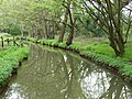
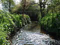
The River Bourne or The Bourne rises southwest of Bisley in Bisley Common [n 1] where it joins the longer Trulley Brook which drains Colony Bog and the middle of the Pirbright Ranges [n 2] , flows between West End and Bisley [n 3] , skirts the south of Chobham, makes a meander into rural north Woking and joins the much longer Mill Bourne to the east of Chobham before flowing between Woodham and Addlestone, then New Haw and Addlestone. Finally passing through some of the town, it enters St George's College, Addlestone (formerly Woburn Park) where the River Bourne joins with the River Bourne (Chertsey branch). [1] The River Bourne then by a manmade channel turns east instead of running the final 100m into the Upper Chertsey Reach; joining the River Thames below the southern weir of Shepperton Lock and its many islands, which due to the barraging of the Thames provides (as was possible before the Thames weirs were built) a greater fall. [2]

Along its lower course, past St George's College, Addlestone (formerly Woburn Park) the river becomes canalized and flows through 20 gardens of the Hamm Court estate, in the ecclesiastical parish of Addlestone and historically civil parish, but adjoining the Weybridge border to reach the Thames below Shepperton Lock.

Upper Tributaries

Windle Brook

The Windle Brook is a small river springing at New England Hill, Swinley Forest, Berkshire a forest with some military use in the Crown Estate with further nearby sources in Bagshot, Surrey. Brooks of Windlesham merge with the Windle Brook below Windlesham Golf Club then flow through Windlesham Arboretum, a public space managed by Surrey Wildlife Trust. [3] The brook runs north of Chobham and through Windlesham, providing the latter with its name. During this journey a few lakes are made, including Rapley Lake and just below a private lake with weir in royal Bagshot Park. [2]

This stream goes straight eastward until before the M3 turning ESE; the Bourne becomes named the Hale Bourne when this joins from the southwest, then heads due east.

The Hale Bourne, Lightwater and Chobham

In a hilly, well-wooded strip of public heath adjoining the off-limits Pirbright Ranges Heath to the south, in Lightwater, the Hale Bourne springs which forms a small lake, Lightwater, surrounded by houses and its flow turns east when it takes on a greater amount of water from the Windle Brook below Broadway Green, Windlebrook and Rectory Farms in Lightwater; then this enlarged Hale Bourne flows into Chobham where it becomes joined by a tributary and known as the Mill Bourne. [4]

The Mill Bourne, Chobham

As soon as joined by Clappers Brook in west Chobham the Hale becomes the Mill Bourne. It passes a recreation ground and Millbourne Bridge through the village centre picking up two main tributaries from the north (as the south is drained by The Bourne, see above), the only named one is Clappers Brook. [n 4] [2] In this straight the Mill Bourne passes Town Mill, the Chobham Museum, Sow Moor and Emmett's Mill before reaching a confluence with The Bourne. This confluence is between the McLaren Technology Centre grounds and Fairoaks Airport.

Knaphill and Parley Brooks

Waterer's Park [n 5] marks the start of an additional stream flowing north from Knaphill, the northern suburb of Woking forming a confluence west of Horsell Common. Just before the confluence is the confluence of the Parley Brook that stems from the Goldsworth Park recreation ground. [2]

Flood Risk

During 12–14 August 2006, much of the civil parish of Chobham suffered from severe floods due to the River Bourne and the Mill Bourne bursting their banks. The floods were caused by heavy rainfall and thunderstorms across the region that resulted in flooded homes and businesses, power cuts and road closures. This caused the rainfall to run across the land to local watercourses and low-lying areas. Two months' rainfall fell in one night and local watercourses were unable to cope with the run off so flooded adjacent land, buildings and roads. [5] [6]

Concerns were express by residents to the parish council that the flooding in Chobham was exacerbated on a small scale by the use of Field 0081, Pennypot Lane, Chobham as a site for travellers who have covered that area with hardcore to support their mobile homes. This area used to be a water meadow absorbing some floodwater from the River Bourne adjacent to the site. [7] Planning permission for the site was refused as this land was seen as providing a river corridor for the River Bourne. [8]

Surrounding Soil, Elevations and Rainfall

The two main watercourses are once past Lightwater/Bisley 2.5–5 m wide flowing over land which is geologically the remains of the sandy Bagshot or Western Surrey formation, where sands and organic matter overlie clay, described as "slowly permeable loamy or peat soils" or "loamy and clayey soils with naturally high groundwater" surrounded by "free-draining naturally wet heath" on higher land, making in the uplands swathes unique, heather, gorse and coniferous habitat interspersed with bogs and brooks. [9]

At Chobham the widest plain of surrounding land forms which is, as drained by ditches and less acidic, fertile and widely used for cultivation. Elevations range as follows:
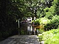
Elevation of Bourne at centreSettlement passedElevations of centre of settlement [10]
53m ("Windle Brook") Bagshot 55-91m
41.5m ("Windle Brook") Windlesham Arboretum 42-46m
43.5m ("Hale Bourne") Lightwater 45.3-60m
31—33m (River Bourne) Bisley 36m-55m
30—32m (River Bourne) West End 31.7-42m (mostly 33-42m)
25m (River Bourne) Chobham (High Street south of Church)26—27.2m
27.2m ("Mill Bourne") Chobham (High Street and all areas off Windsor Road north of Church)27.5-39m
15–15.5m New Haw Golf Fun and Driving Range15.5-16.2m
11.5–14m Addlestone 13-21m

Local annual rainfall is about 635 mm.[ citation needed ]

Fishing

Being capable of the grant of private land fishing rights by all adjoining landowners, not being a navigable river, several fishing groups use the river without need for government body permits.

Bourne Anglers, for instance is a small fishing club/conservation group, started in 2013. The club has been set up to maintain the river and with kind permission of various landowners has kept stretches a free fishing river.

See also

Notes and references

Notes
  1. Specifically in the western part of Bisley Common, part of the Ministry of Defence Pirbright Ranges. Bisley Common denotes two commons; the one that has these headwaters does not refer to the full public access common also known as "Reidon Hill" by Knaphill.
  2. The Chobham and Pirbright Commons a Surrey Wildlife Trust area most of which is a military training area includes such areas as Strawberry Hill, Strawberry Bottom, Colony Bog, Lovelands Hill and Brock Hill
  3. Bisley and West End both have the Ranges and Heath to the west
  4. Clappers Brook rises in Valley End, Surrey west of Staple Hill the highest point of Chobham Common
  5. Waterer's Park is a public park
References
  1. Note that KT15 reveals Addlestone includes Woburn Park — as when it was one parish, Chertsey, Addlestone on all boundaries occupies almost all land west of the River Wey
  2. 1 2 3 4 Map created by Ordnance Survey, courtesy of English Heritage
  3. Surrey Wildlife Trust - Windlesham Arboretum
  4. Rectory Farm Grade II* architectural listing entry and map in Lightwater Historic England. "Details from listed building database (1030001)". National Heritage List for England . Retrieved 16 November 2012.
  5. Surrey Heath Borough Council - Flood info
  6. 2006 Flood news
  7. Campaign to Protect Rural England
  8. Government News Network
  9. National Soil Resources Institute – Cranfield University
  10. Grid reference Finder measurement tools

Coordinates: 51°22′43″N0°27′50″W / 51.3785°N 0.4639°W / 51.3785; -0.4639 (Rivers Bourne (Chertsey & Addlestone))

Next confluence upstream River Thames Next confluence downstream
Abbey River (south)River Bourne, Addlestone with River Bourne, Chertsey Wey and Godalming Navigations (south)

Related Research Articles

Surrey Heath Place in England

Surrey Heath is a local government district with borough status in Surrey, England. Its council is based in Camberley. Much of the area is within the Metropolitan Green Belt.

Chobham Human settlement in England

Chobham is a village and civil parish in the Borough of Surrey Heath in Surrey, England.

River Bourne may refer to:

Bagshot Human settlement in England

Bagshot is a village in the Surrey Heath borough of Surrey, England, approximately 26 miles (42 km) southwest of central London. In the past, Bagshot served as an important staging post between London, Southampton and the West Country, evidenced by the original coaching inns still present in the town today.

Windlesham Human settlement in England

Windlesham is a village in the Surrey Heath borough of Surrey, England, approximately 25 miles (40 km) south west of central London. Its name derives from the Windle Brook, which runs south of the village into Chobham, and the common suffix 'ham', the Old English word for 'homestead'. The civil parish of Windlesham has a population of 17,000 and includes the neighbouring villages of Bagshot and Lightwater.

Addlestone Human settlement in England

Addlestone is a town in Surrey, England. It is located approximately 18.6 mi (29.9 km) southwest of London. The town is the administrative centre of the Borough of Runnymede, of which it is the largest settlement.

Lightwater Human settlement in England

Lightwater is a village in the Surrey Heath district of Surrey, England, about 27 miles (43 km) southwest of central London. Immediately surrounding towns and villages include Bagshot, Deepcut, Windlesham, Camberley, and West End, Woking. It is bounded to the north-west by the M3 motorway and to the north-east by the "Lightwater Bypass" (A322). To the south-east it is bounded by the "Red Road" (B311), while to the south-west there are vehicle-testing tracks owned by the Ministry of Defence.

Ash, Surrey Village in England

Ash is a village and civil parish in the far west of the borough of Guildford, Surrey. Ash is on the eastern side of the River Blackwater, with a station on the Reading-Guildford-Gatwick line, and direct roads to Aldershot, Farnham and Guildford. The 2011 census counted the residents of the main ward of Ash, which excludes Ash Vale, as 6,120. It is within the Aldershot Urban Area and adjoins the riverside in the east of that large town; Ash has a small museum in the local cemetery chapel, a large secondary school and a library.

Chertsey sometimes seen as Surrey North Western, equally the North Western Division of Surrey was created as one of six county constituencies of Surrey for the House of Commons of the UK Parliament. The seat underwent two net reductions and variously included and excluded growing suburban settlements: Egham, Frimley, Weybridge, Walton-on-Thames and Woking.

West End, Surrey Human settlement in England

West End is a village and civil parish in Surrey Heath, Surrey, England, approximately 25 miles (40 km) southwest of central London. It is midway between the towns of Camberley and Woking, 4 mi (6.4 km) to the west and east respectively. The River Bourne rises from its sources to the immediate west to run through the village. Until the mid 20th century, the West End consisted of a collection of smallholdings surrounded by a substantial area of common land

River Bourne, Chertsey River in Berkshire and Surrey, England

The River Bourne or the Chertsey Bourne is in Berkshire and Surrey; it runs from sources in Windsor Great Park and Swinley Forest through to the River Thames.

Bourne or Bourn may refer to:

River Wey River in southern England

The River Wey is a tributary of the River Thames in south east England. Its two branches, one of which rises near Alton in Hampshire and the other in West Sussex to the south of Haslemere, join at Tilford in Surrey. Once combined the flow is eastwards then northwards via Godalming and Guildford to meet the Thames at Weybridge. Downstream the river forms the backdrop to Newark Priory and Brooklands. The Wey and Godalming Navigations were built in the 17th and 18th centuries, to create a navigable route from Godalming to the Thames.

Windlesham Arboretum

Windlesham Arboretum is between the villages of Windlesham and Lightwater in Surrey, United Kingdom. The arboretum features lakes, monuments, follies, a small chapel and approximately 22,000 mature and rare trees. The Windle Brook runs through the arboretum and has seven main footbridges and approximately ten ponds on each side, some of which are more properly identifiable as lakes based on size. The land and lakes, including a scattered number of buildings altogether consist of just over 1 square kilometre (0.39 sq mi).

Geology of Surrey

The geology of Surrey is dominated by sedimentary strata from the Cretaceous, overlaid by clay and superficial deposits from the Cenozoic.

Bisley and West End Commons

Bisley and West End Commons is a 37.2-hectare (92-acre) Local Nature Reserve west of Woking in Surrey. It is part of the 46-hectare (110-acre) Bisley & West End Commons and Reidon Hill nature reserve, which is owned by Surrey County Council and managed by Surrey Wildlife Trust. The site is also part of the Colony Bog and Bagshot Heath Site of Special Scientific Interest, the Thursley, Ash, Pirbright & Chobham Special Area of Conservation and the Thames Basin Heaths Special Protection Area,