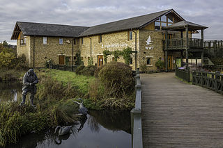
WWT London Wetland Centre is a wetland reserve managed by the Wildfowl and Wetlands Trust in the Barnes area of the London Borough of Richmond upon Thames, southwest London, England, by Barn Elms. The site is formed of four disused Victorian reservoirs tucked into a loop in the Thames.

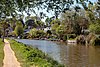
The Cotswold Water Park is the United Kingdom's largest marl lake system, straddling the Wiltshire–Gloucestershire border, northwest of Cricklade and south of Cirencester. There are 180 lakes, spread over 42 square miles (110 km2).

Sevenoaks Gravel Pits is a 73.7-hectare (182-acre) biological Site of Special Scientific Interest on the northern outskirts of Sevenoaks in Kent. It is managed by Kent Wildlife Trust as the Sevenoaks Wildlife Reserve and Jeffery Harrison Visitor Centre.

The River Lee Country Park is located in the Lee Valley Park and is managed by the Lee Valley Regional Park Authority. Covering 1,000 acres (400 ha) on either side of the River Lee Navigation between Waltham Abbey and Broxbourne, it is an area of lakes, watercourses, open spaces and three Sites of Special Scientific Interest (SSSI) linked by footpaths and cycle tracks.
The Turnford and Cheshunt Pits is a biological Site of Special Scientific Interest near Cheshunt in Hertfordshire and Essex and covers a total of 428.17 acres. It is part of the Lee Valley Special Protection Area.

Lackford Lakes is a 105.8-hectare (261-acre) biological Site of Special Scientific Interest (SSSI) north and east of Lackford in Suffolk. The SSSI is part of the 131-hectare (320-acre) Lackford Lakes nature reserve, which is managed by the Suffolk Wildlife Trust.

The Idle Valley Nature Reserve, also known as Lound Gravel Pits or Sutton and Lound Gravel Pits, is a wetland Site of Special Scientific Interest (SSSI) situated north-west of the town of Retford in the Bassetlaw district of north Nottinghamshire. The nature reserve is situated along the western bank of the River Idle and east of the villages of Sutton cum Lound and Lound. The nature reserve is managed by the Nottinghamshire Wildlife Trust.

Mid Colne Valley is a 132 hectare biological Site of Special Scientific Interest in Harefield in the London Borough of Hillingdon and Denham in South Buckinghamshire. Its main importance lies in its extensive diversity of birdlife in lakes in former gravel pits.

Amwell Quarry or Amwell Nature Reserve is a 37 hectare biological Site of Special Scientific Interest in Great Amwell in Hertfordshire. The planning authority is East Hertfordshire District Council. It is also part of the Lee Valley Ramsar Site and Special Protection Area, and is owned and managed by the Hertfordshire and Middlesex Wildlife Trust.

Ardleigh Gravel Pit is a 1.2-hectare (3.0-acre) geological Site of Special Scientific Interest south of Ardleigh in Essex. It is a Geological Conservation Review site.

Cam Washes is a 166.5-hectare (411-acre) biological Site of Special Scientific Interest west of Wicken in Cambridgeshire.

Little Paxton Pits is a 127.4-hectare (315-acre) biological Site of Special Scientific Interest in Little Paxton in Cambridgeshire. Part of it is also a 60 hectare Local Nature Reserve (LNR).

Titchmarsh Nature Reserve is a 72.7 hectare Local Nature Reserve north of Thrapston in North Northamptonshire. It is owned and managed by the Wildlife Trust for Bedfordshire, Cambridgeshire and Northamptonshire. It is part of the Upper Nene Valley Gravel Pits Site of Special Scientific Interest.

Wraysbury No 1 Gravel Pit is a 58.0-hectare (143-acre) biological Site of Special Scientific Interest in Wraysbury in Berkshire. It is part of South West London Waterbodies Ramsar site, and Special Protection Area. The lake has a surface area of 39.6 hectares(97.85 acres). The site has an area of 58.0-hectare (143-acre) and the lake 39.6-hectare (98-acre). The pit was excavated in the 1920s and 1930s with gravel being removed from the site. Over the years plants and wildlife have colonised the area and it is now mature.

Wraysbury and Hythe End Gravel Pits is a 117.2-hectare (290-acre) biological Site of Special Scientific Interest in Wraysbury in Berkshire. It is part of South West London Waterbodies Ramsar site and Special Protection Area.
Gunton Park Lake is a 18.3-hectare (45-acre) biological Site of Special Scientific Interest by Gunton Hall, north-west of North Walsham in Norfolk. It was formed by damming Hagon Beck.

Knight and Bessborough Reservoirs is a 63.4-hectare (157-acre) biological Site of Special Scientific Interest in Walton-on-Thames in Surrey. It is part of South West London Waterbodies Ramsar site and Special Protection Area

Hay-a-Park Gravel Pit is a Site of Special Scientific Interest, or SSSI, adjacent to the east side of the town of Knaresborough, North Yorkshire, England. Having been a disused and flooded quarry since the 1970s, it now consists of the large Hay-a-Park Lake and three smaller ponds, besides associated reedbeds, scrub, woodland and grassland. It was designated as a SSSI in 1995 because it supports a number of wintering birds, including a large flock of goosander. This site is "one of the most northerly inland breeding populations of reed warbler in Britain." Hay-a-Park was once part of a royal park, an early landowner being Edward II.

Deeping Lakes Nature Reserve, also known as Deeping Gravel Pits is a local nature reserve with an area of over 160 acres located south-east of Deeping St James in Lincolnshire, England. It includes part of the Deeping Gravel Pits SSSI and is placed within a Higher Level Stewardship scheme.