Charterhouse to Eashing

Last updated
Charterhouse to Eashing
Site of Special Scientific Interest
Woodland glade, Hurtmore Bottom, Shackleford - geograph.org.uk - 171802.jpg
Area of Search Surrey
Grid reference SU 951 443 [1]
Interest Biological
Area 68.4 hectares (169 acres) [1]
Notification 1986 [1]
Location map Magic Map

Charterhouse to Eashing is a 68.4-hectare (169-acre) biological Site of Special Scientific Interest west of Godalming in Surrey. [1] [2]

Site of Special Scientific Interest Conservation designation denoting a protected area in the United Kingdom

A Site of Special Scientific Interest (SSSI) in Great Britain or an Area of Special Scientific Interest (ASSI) in the Isle of Man and Northern Ireland is a conservation designation denoting a protected area in the United Kingdom and Isle of Man. SSSI/ASSIs are the basic building block of site-based nature conservation legislation and most other legal nature/geological conservation designations in the United Kingdom are based upon them, including national nature reserves, Ramsar sites, Special Protection Areas, and Special Areas of Conservation. The acronym "SSSI" is often pronounced "triple-S I".

Godalming town in the Borough of Waverley in Surrey, England

Godalming is a historic market town, civil parish and administrative centre of the Borough of Waverley in Surrey, England, 4 miles SSW of Guildford. The town traverses the banks of the River Wey in the Greensand Ridge – a hilly, heavily wooded part of the outer London commuter belt and Green Belt. In 1881, it became the first place in the world to have a public electricity supply and electric street lighting.

Surrey County of England

Surrey is a subdivision of the English region of South East England in the United Kingdom. A historic and ceremonial county, Surrey is also one of the home counties. The county borders Kent to the east, East and West Sussex to the south, Hampshire to the west, Berkshire to the northwest, and Greater London to the northeast.

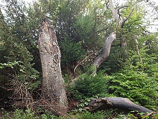
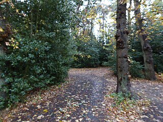
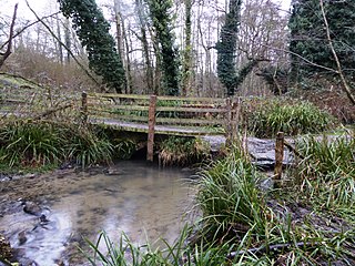
This is a steep valley cut through a broad flood plain. Much of the site is wooded, with areas of tall fen, grassland and standing water. There is a diverse fly population, including several rare species, such as Lonchoptera scutellata cranefly , Stratiomys potamida and the cranefly Gonomyia bifida . [3]

Fly order of insects

Flies are insects with a pair of functional wings for flight and a pair of vestigial hindwings called halteres for balance. They are classified as an order called Diptera, that name being derived from the Greek δι- di- "two", and πτερόν pteron "wings". The order Diptera is divided into two suborders, with about 110 families divided between them; the families contain an estimated 1,000,000 species, including the familiar housefly, horse-fly, crane fly, and hoverfly; although only about 125,000 species have a species description published. The earliest fly fossils found so far are from the Triassic, about 240 million years ago; phylogenetic analysis suggests that flies originated in the Permian, about 260 million years ago.

<i>Stratiomys potamida</i> species of insect

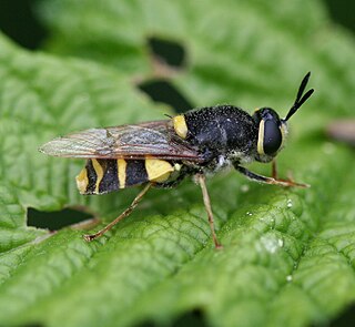
Stratiomys potamida, the banded general, is a European species of soldier fly.

Related Research Articles

Windsor Forest and Great Park

Windsor Forest and Great Park is a 1,778.9-hectare (4,396-acre) biological Site of Special Scientific Interest in Berkshire and Surrey, located south of Windsor. It is a Special Area of Conservation and Windsor Forest is a Nature Conservation Review site, Grade I. Landscaped woodland gardens are Grade I listed on the Register of Historic Parks and Gardens of Special Historic Interest. Windsor Great Park is a Royal Park of 2,020 hectares, including a deer park,

Auclaye

Auclaye is a 0.6-hectare (1.5-acre) geological Site of Special Scientific Interest south of Capel in Surrey. It is a Geological Conservation Review site.

Blackheath SSSI, Surrey

Blackheath is a 141.6-hectare (350-acre) biological Site of Special Scientific Interest south-east of Guildford in Surrey.

Chiddingfold Forest

Chiddingfold Forest is a 542.5-hectare (1,341-acre) biological Site of Special Scientific Interest in Chiddingfold in Surrey and West Sussex. One part of it, Fir Tree Copse, is a nature reserve which is managed by the Surrey Wildlife Trust

Chipstead Downs

Chipstead Downs is a 157.8-hectare (390-acre) biological Site of Special Scientific Interest south-east of Banstead in Surrey. Part of it is Park Downs, which is managed by the Banstead Commons Conservators.

Colony Bog and Bagshot Heath

Colony Bog and Bagshot Heath is a 1,130.5-hectare (2,794-acre) biological Site of Special Scientific Interest between Camberley and Woking in Surrey. Part of it is a Nature Conservation Review site, Grade I. It is part of the Thames Basin Heaths Special Protection Area and the Thursley, Ash, Pirbright and Chobham Special Area of Conservation. It includes Brentmoor Heath, a Local Nature Reserve which is managed by the Surrey Wildlife Trust

Combe Bottom

Combe Bottom is a 42.1-hectare (104-acre) biological Site of Special Scientific Interest north of Shere in Surrey. It is designated a Local Nature Reserve called Shere Woodlands, and is managed by the Surrey Wildlife Trust.

Glovers Wood

Glover's Wood is a 74.5-hectare (184-acre) biological Site of Special Scientific Interest east of Charlwood in Surrey. It is a Nature Conservation Review site, Grade 2.

Godstone Ponds

Godstone Ponds is a 13.6-hectare (34-acre) biological Site of Special Scientific Interest in Godstone in Surrey. Bay Pond is an educational nature reserve closed to the public which is managed by the Surrey Wildlife Trust.

Gong Hill

Gong Hill is a 5.9-hectare (15-acre) biological Site of Special Scientific Interest south of Farnham in Surrey.

Hedgecourt

Hedgecourt is a 33.6-hectare (83-acre) biological Site of Special Scientific Interest west of Felbridge in Surrey. An area of 5-hectare (12-acre) is managed by the Surrey Wildlife Trust.

Quarry Hangers

Quarry Hangers is a 28.5-hectare (70-acre) biological Site of Special Scientific Interest south-west of Caterham in Surrey. An area of 11 hectares is a nature reserve managed by the Surrey Wildlife Trust.

Seale Chalk Pit

Seale Chalk Pit is a 1.2-hectare (3.0-acre) geological Site of Special Scientific Interest west of Guildford in Surrey. It is a Geological Conservation Review site and part of the Seale Chalk Pit and Meadow 3-hectare (7.4-acre) private nature reserve, which is managed by the Surrey Wildlife Trust.

Titsey Woods

Titsey Woods is a 45.3-hectare (112-acre) biological Site of Special Scientific Interest north-west of Oxted in Surrey.

Vann Lake and Ockley Woods

Vann Lake and Ockley Woods is a 57.8-hectare (143-acre) biological Site of Special Scientific Interest south of Ockley in Surrey. Vann Lake is part of Vann Lake and Candy's Copse, a nature reserve managed by the Surrey Wildlife Trust.

Wey Valley Meadows

Wey Valley Meadows is a 94.1-hectare (233-acre) biological Site of Special Scientific Interest north of Godalming in Surrey.

Seabrook Stream

Seabrook Stream is a 24.1-hectare (60-acre) biological Site of Special Scientific Interest Kent.

Blindley Heath SSSI

Blindley Heath SSSI is a 26.3-hectare (65-acre) biological Site of Special Scientific Interest in the hamlet Blindley Heath, on the southern outskirts of Godstone in Surrey. It is also a Local Nature Reserve. It is owned by Godstone Parish Council and managed by the Surrey Wildlife Trust

Knight and Bessborough Reservoirs

Knight and Bessborough Reservoirs is a 63.4-hectare (157-acre) biological Site of Special Scientific Interest in Walton-on-Thames in Surrey. It is part of South West London Waterbodies Ramsar site and Special Protection Area

Poors Allotment

Poors Allotment is a 76-hectare (190-acre) nature reserve north of Camberley in Surrey. It is owned by Windlesham United Charities and managed by the Surrey Wildlife Trust. It is part of Thames Basin Heaths Special Protection Area and Broadmoor to Bagshot Woods and Heaths Site of Special Scientific Interest.

References

  1. 1 2 3 4 "Designated Sites View: Charterhouse to Eashing". Sites of Special Scientific Interest. Natural England. Retrieved 5 November 2018.
  2. "Map of Charterhouse to Eashing". Sites of Special Scientific Interest. Natural England. Retrieved 5 November 2018.
  3. "Charterhouse to Eashing citation" (PDF). Sites of Special Scientific Interest. Natural England. Retrieved 5 November 2018.

Coordinates: 51°11′24″N0°38′28″W / 51.190°N 0.641°W / 51.190; -0.641

Geographic coordinate system Coordinate system

A geographic coordinate system is a coordinate system that enables every location on Earth to be specified by a set of numbers, letters or symbols. The coordinates are often chosen such that one of the numbers represents a vertical position and two or three of the numbers represent a horizontal position; alternatively, a geographic position may be expressed in a combined three-dimensional Cartesian vector. A common choice of coordinates is latitude, longitude and elevation. To specify a location on a plane requires a map projection.