
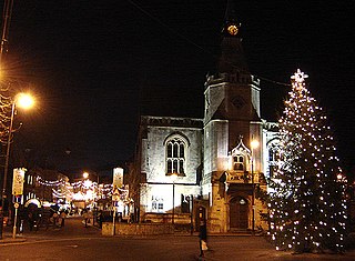
Banbury is a historic market town on the River Cherwell in Oxfordshire, South East England. It had a population of 54,335 at the 2021 Census.

The River Cherwell is a tributary of the River Thames in central England. It rises near Hellidon, Northamptonshire and flows southwards for 40 miles (64 km) to meet the Thames at Oxford in Oxfordshire.
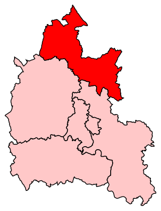
Banbury, also informally known as Banbury and North Oxfordshire, is a constituency in Oxfordshire created in 1553 and represented in the House of Commons of the UK Parliament since 2015 by Victoria Prentis of the Conservative Party. She currently serves as Attorney General for England and Wales.

Banbury railway station serves the town of Banbury in Oxfordshire, England. The station is operated by Chiltern Railways, on the Chiltern Main Line, and has four platforms in use.

Grimsbury is a largely residential area which forms the eastern part of Banbury, Oxfordshire, England. It is situated east of the River Cherwell, the Oxford Canal and the Cherwell Valley Line railway.

Neithrop is an inner housing estate and part of the greater 'Neithrop ward' of Banbury, Oxfordshire, England. It is one of the oldest areas in Banbury, having first been first recorded as a hamlet in the 13th century. Neithrop, Woodgreen and Bretch Hill are three interconnecting housing estates.

Easington, Poets Corner and the Timms estate are three interconnecting estates in the town of Banbury, Oxfordshire.

Calthorpe is an historic manor in Oxfordshire, now a ward in the town of Banbury, Oxfordshire. It contains the modern housing estates of Cherwell Heights and Calthorpe.
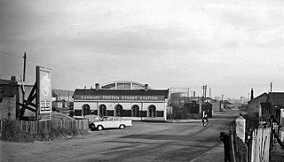
Banbury Merton Street was the first railway station to serve the Oxfordshire market town of Banbury in England. It opened in 1850 as the northern terminus of the Buckinghamshire Railway providing connections to Bletchley and Oxford and closing for passengers in 1961 and goods in 1966.

The Lee Valley Reservoir Chain is located in the Lee Valley, and comprises 13 reservoirs that supply drinking water to London.

Banbury Reservoir is located in the London Borough of Waltham Forest at Walthamstow. It is one of the storage reservoirs in the Lee Valley Reservoir Chain. The reservoir is owned by Thames Water.
The 2003 Cherwell District Council election took place on 1 May 2003 to elect members of Cherwell District Council in Oxfordshire, England. One third of the council was up for election and the Conservative Party stayed in overall control of the council.
The 2006 Cherwell District Council election took place on 4 May 2006 to elect members of Cherwell District Council in Oxfordshire, England. One third of the council was up for election and the Conservative Party stayed in overall control of the council.

Grimsbury Castle is an Iron Age "multiple enclosure" Hill Fort comprising a large circular encampment situated on a high hill. It is situated within Grimsbury Wood, between Cold Ash and Hermitage, in the county of Berkshire.
Banbury is a circa 1,500-year-old market town and civil parish on the River Cherwell in the Cherwell District of Oxfordshire, England. It is 64 miles (103 km) northwest of London, 38 miles (61 km) southeast of Birmingham, 27 miles (43 km) south of Coventry and 21 miles (34 km) north northwest of the county town of Oxford.
The 2011 Cherwell District Council election took place on 5 May 2011 to elect members of Cherwell District Council in Oxfordshire, England. One third of the council was up for election and the Conservative Party stayed in overall control of the council.
National Filling Factory, Banbury, officially called National Filling Factory No. 9. was a British Ministry of Munitions filling factory, constructed during World War I and located in Banbury, Oxfordshire. The production of filled shells began in April 1916 and ended when the factory closed in 1924
Nethercote is a hamlet on the edge of north Oxfordshire, a semi-rural area bordering with West Northamptonshire. The hamlet sits South East of J11 of M40, lying South of the A422 and East of the M40. Predominantly agricultural land used for grazing, a single-track road runs right through the hamlet, known as Banbury Lane, which has around a dozen residential properties along the lane. Banbury Lane is still often referred to as Blacklocks Hill and this refers to the history of the area and a time when this area saw a main route into Banbury, before the M40 and A422. In 1870-72 it had a population of 97.
This page is based on this
Wikipedia article Text is available under the
CC BY-SA 4.0 license; additional terms may apply.
Images, videos and audio are available under their respective licenses.
