Abrams Creek (Tennessee)

Last updated
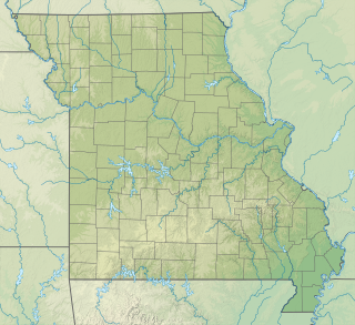
Abrams Creek
Tributary to Little Tennessee River
Abrams Creek Near Trailhead.JPG
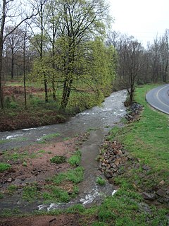
Abrams Creek near Trailhead
USA Tennessee relief location map.svg
Red pog.svg
Location of Abrams Creek mouth
Usa edcp relief location map.png
Red pog.svg
Abrams Creek (Tennessee) (the United States)
Location
Country United States
State Tennessee
County Blount
Physical characteristics
Sourceconfluence of Anthony Creek and Left Prong Anthony Creek
  locationwest of Cold Water Knob
  coordinates 35°35′20″N083°45′28″W / 35.58889°N 83.75778°W / 35.58889; -83.75778 [1]
  elevation2,440 ft (740 m) [2]
Mouth Little Tennessee River
  location
about 5 miles north of Calderwood, Tennessee
  coordinates
35°33′20″N083°59′56″W / 35.55556°N 83.99889°W / 35.55556; -83.99889 Coordinates: 35°33′20″N083°59′56″W / 35.55556°N 83.99889°W / 35.55556; -83.99889 [1]
  elevation
874 ft (266 m) [3]
Length27.60 mi (44.42 km) [4]
Basin size87.14 square miles (225.7 km2) [5]
Discharge 
  location Little Tennessee River
  average215.53 cu ft/s (6.103 m3/s) at mouth with Little Tennessee River [5]
Basin features
Progression Little Tennessee RiverTennessee RiverOhio RiverMississippi RiverGulf of Mexico
River system Ohio River
Tributaries 
  leftLeft Prong Anthony Creek, Maywood Creek, Sea Branch, Maple Branch, McCaulley Branch, Cades Branch, Whistling Branch, Mill Creek, More Licker Branch, Law Branch, McCully Branch, Pardon Branch, Mill Branch, Shoofly Branch, Huckleberry Branch, Panther Creek
  rightAnthony Creek, Green Branch, Crooked Arm Branch, Harrison Branch, Marthas Branch, Feezell Branch, Tater Branch, Arbutus Branch, Stony Branch, Kreider Branch, Oak Flats Branch, Mill Branch, Buck Shank Branch, Kingfisher Creek, Bell Branch, Mill Creek
BridgesCades Cove Loop Road, Sparks Lane, Hyatt Lane, Cades Cove Loop Road, US 129

Abrams Creek is a creek in Blount County, Tennessee. Its headwaters are in Cades Cove, and it is a tributary of the Little Tennessee River. [6] [7] It is named after the Chilhowee Cherokee chief Old Abraham ("Abram"). [7] Visitors swim and fish in the creek. [8] The creek was deliberately poisoned in 1957 to kill fish in potential competition with rainbow trout; many fish species were extirpated from the river and have never recovered. [6]

Contents

Variant names

According to the Geographic Names Information System, it has also been known historically as: [1]

Course

Abrams Creek begins at the confluence of Anthony Creek and Left Prong Anthony Creek west of Cold Water Knob, in Blount County, Tennessee and then flows generally west to join the Little Tennessee River in Chilhowee Lake approximately five miles north of Calderwood. [3]

Watershed

Abrams Creek drains 87.14 square miles (225.7 km2) of area, receives about 62.7 in/year of precipitation, has a wetness index of 254.58, and is about 94% forested. [5]

See also

Related Research Articles

Abram Creek (West Virginia)

Abram Creek is a 19.4-mile-long (31.2 km) tributary stream of the North Branch Potomac River in Grant and Mineral counties in West Virginia's Eastern Panhandle.

Abrams Creek (Virginia) Stream in Virginia, USA

Abrams Creek is an 11.2-mile-long (18.0 km) tributary stream of Opequon Creek in Frederick County and the independent city of Winchester in Virginia. Abrams Creek rises north of Round Hill and flows in a southeasterly direction through Winchester. From Winchester, Abrams Creek flows east into Opequon Creek. The stream was originally known as Abraham's Creek.

Happy Valley, Blount County, Tennessee Unincorporated community in Tennessee, United States

Happy Valley is an unincorporated community in Blount County, Tennessee, United States, near the Great Smoky Mountains National Park. Although it is not a census-designated place, the ZIP Code Tabulation Area for the ZIP Code (37878) that serves Happy Valley had a population of 529 as of the 2000 U.S. Census.

Walland, Tennessee Census-designated place in Tennessee, United States

Walland is an unincorporated community and census-designated place (CDP) in Blount County, Tennessee, in the Southeastern United States. Its population was 259 as of the 2010 census. Walland is the site of a post office and is the place name associated with zip code 37886, which covers an area beyond the Walland community.

Courtois Creek Stream in Virginia, USA

Courtois Creek is a 38.6-mile-long (62.1 km) stream in southern Missouri, United States. It shares its name with the nearby town of Courtois and is in the Courtois Hills region of the Missouri Ozarks. According to the information in the Ramsay Place Names File at the University of Missouri, the creek was "doubtless named for some French settler, but his identity has not been ascertained".

Chilhowee (Cherokee town) Cherokee village site in Blount and Monroe Counties, Tennessee

Chilhowee was a prehistoric and historic Native American site in present-day Blount and Monroe counties in Tennessee, in what were the Southeastern Woodlands. Although now submerged by the Chilhowee Lake impoundment of the Little Tennessee River, the Chilhowee site was home to a substantial 18th-century Overhill Cherokee town. It may have been the site of the older Creek village "Chalahume" visited by Spanish explorer Juan Pardo in 1567. The Cherokee later pushed the Muscogee Creek out of this area.

Allegheny Creek Stream in Pennsylvania, USA

Allegheny Creek is an 11.3-mile-long (18.2 km) tributary of the Schuylkill River in Berks County, Pennsylvania in the United States.

Ackerson Creek Stream in California, USA

Ackerson Creek is a stream in Tuolumne County, California, in the United States. It is a tributary of the South Fork Tuolumne River.

Alder Creek (Mariposa County, California) Stream in California, USA


Alder Creek is a stream in Mariposa County, California, in the United States. It is a tributary of the South Fork Merced River.

Alger Creek Stream in Mississippi, USA

Alger Creek is a stream in Mono County, California, in the United States.

Ackerman Creek Stream in California, USA

Ackerman Creek is a stream located in the U.S. state of California. It is located in Mendocino County.

Abrams Run Stream in West Virginia, USA

Abrams Run is a stream in the U.S. state of West Virginia.

Alampa Creek Stream in Mississippi, USA

Alampa Creek is a stream in the U.S. state of Mississippi. It is a tributary to Pinishook Creek.

Dutch Fork (Buffalo Creek tributary) Stream in Pennsylvania, USA

Dutch Fork is a 11.23 mi (18.07 km) long 3rd order tributary to Buffalo Creek in Washington County, Pennsylvania.

Cross Creek (Ohio River tributary) Tributary of the Ohio River

Cross Creek is a 21.71 mi (34.94 km) long 4th order tributary to the Ohio River in Brooke County, West Virginia.

Kings Creek (Ohio River tributary) Tributary of the Ohio River

Kings Creek is a 15.23 mi (24.51 km) long 4th order tributary to the Ohio River in Hancock County, West Virginia.

Little Wheeling Creek Stream in West Virginia, USA

Little Wheeling Creek is a 5.37 mi (8.64 km) long 4th order tributary to Wheeling Creek in Ohio County, West Virginia.

Middle Wheeling Creek Stream in West Virginia, USA

Middle Wheeling Creek is a 15.11 mi (24.32 km) long 3rd order tributary to Little Wheeling Creek in Ohio County, West Virginia.

Cherrystone Creek Stream in Virginia, USA

Cherrystone Creek is a 13.36 mi (21.50 km) long 3rd order tributary to the Banister River in Pittsylvania County, Virginia. This is the only stream of this name in the United States.

Lawsons Creek (Dan River tributary) Stream in Virginia, USA

Lawsons Creek is a 13.44 mi (21.63 km) long 4th order tributary to the Dan River in Halifax County, Virginia.

References

  1. 1 2 3 "GNIS Detail - Abrams Creek". geonames.usgs.gov. US Geological Survey. Retrieved 11 June 2021.
  2. "Get Maps". USGS Topoview. US Geological Survey. Retrieved 11 June 2021.
  3. 1 2 "Get Maps". USGS Topoview. US Geological Survey. Retrieved 11 June 2021.
  4. "ArcGIS Web Application". epa.maps.arcgis.com. US EPA. Retrieved 11 June 2021.
  5. 1 2 3 "Abrams Creek Watershed Report". US EPA Geoviewer. US EPA. Retrieved 11 June 2021.
  6. 1 2 John Peine; Samab Foundation (1998). Ecosystem Management for Sustainability: Principles and Practices Illustrated by a Regional Biosphere Reserve Cooperative. CRC Press. p. 50. ISBN   978-1-57444-053-9.
  7. 1 2 Vicki Rozema (2007). Footsteps of the Cherokees, 2nd ed. John F. Blair. p. 171. ISBN   978-0-89587-421-4.
  8. Margaret Littman (19 March 2013). Moon Tennessee. Avalon Travel. p. 411. ISBN   978-1-61238-150-3.