Judaculla Rock

Last updated

Judaculla Rock
Judaculla Rock, Caney Fork, NC Aug 2019.jpg
Judaculla Rock, August 2018
USA North Carolina location map.svg
Red pog.svg
Usa edcp location map.svg
Red pog.svg
Location552 Judaculla Rock Rd., Cullowhee, North Carolina
Coordinates 35°18′02″N83°06′34″W / 35.30056°N 83.10944°W / 35.30056; -83.10944
NRHP reference No. 13000116 [1]
Added to NRHPMarch 27, 2013

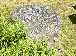
Judaculla Rock is a curvilinear-shaped outcrop of soapstone known for its ancient carvings and petroglyphs. The archaeological site is located on a 0.85-acre rectangular-shaped property, now owned by Jackson County. It is approximately 60 meters east of Caney Fork Creek, a major branch of the northwestward-trending Tuckasegee River in the mountains of Western North Carolina.

Contents

The petroglyph boulder occurs within a man-made bowl-shaped depression. Today the land is covered with mowed turf grass (previously, it was cultivated as a cornfield) and bordered on the west by a thicket of rivercane ( Arundinaria gigantea ). Slightly upslope and east of the boulder are a few smaller outcroppings of soapstone bedrock, at least two of which show definite scars left by ancient quarrying for soapstone bowl manufacture. [2] The site is listed on the National Register of Historic Places.

Description

The surface of the westward-slanting main boulder is covered with petroglyphs. It measures roughly 22 square meters (240 sq ft). The boulder carries scars resulting from soapstone bowl extraction. Three depressions show stem extraction to make pipes, and three more are hollow scallops. [3]

Numerous petroglyphs have been pecked and incised into the surface. The densely packed motifs, especially those along the upper two-thirds of the boulder, often make it difficult to distinguish among the carvings. A minimum count of the patterns has revealed 1,458 cup marks, 47 curvilinear units, 10 bowl-shaped depressions, 10 stick-like figures, 9 rills, 3 concentric rings designs, 3 curvilinear motifs, 3 deer tracks, 3 claw-like imprints, 1 arc, 1 cross-in-circle, and 1 winged shape.

Date range

Petroglyphs that occur within three hollow scallops suggest that their production took place after soapstone bowl quarrying had ceased at the site. This finding is supported by similar overlaps at a smaller soapstone boulder, Brinkley Rock, in western North Carolina and two others, Track Rock Gap and Sprayberry Rock in northern Georgia. [3]

In terms of stylistic cross-dating, the similarity between the concentric ring and cross-in-ring petroglyphs on the boulder with patterns on ceramics from the region suggests that the petroglyphs, made over the Late Archaic soapstone extraction scars, date somewhere between the Middle Woodland and late Mississippian culture periods, roughly 200 CE to 1400 CE. [4]

Controlled archaeological excavations around the boulder revealed deposits that were extensively disturbed in historic times, likely by cultivation. This disrupted researchers' ability to date levels of soils. [5] But, auger sampling of soils higher on the slope suggest intact layers remain. [6] These layers, containing soapstone and lithic fragments left by soapstone bowl manufacture, probably date to the Late Archaic period (say, 2000 to 1000 BCE). [7] [8]

Cherokee oral history

Judaculla Rock retains a special significance for the Cherokee. The majority of Cherokee people were forcibly removed to Indian Territory in 1838, but both the tribes in Oklahoma and the one in North Carolina continue to teach their oral history. [9] Cherokee accounts link Judaculla (also known as Tuli-cula/Juthcullah/Tsul 'Kalu ), their slant-eyed Master-of-Game, [10] with the surrounding landscape, including landforms, rivers, and Cherokee towns. [11]

The petroglyph boulder is located on an old trail that linked the former Cherokee townhouse at Cullowhee, or "Juthcullah's Place," with Judaculla's reputed townhouse within Tannasee Bald (also known as Tsunegûñyĭ). [12] Today the federally recognized Eastern Band of Cherokee Indians is based in Swain and Jackson counties in Western North Carolina. They and the two Cherokee tribes in Oklahoma continue to regard this boulder as spiritually significant.

Significance

From a rock art perspective, the boulder is significant as it contains more petroglyphs than any other known boulder east of the Mississippi River. Judaculla Rock contains approximately 1,548 motifs, 3.7 times the total of 421 motifs at the substantial Track Rock Gap petroglyph boulder complex in far northern Georgia.

From an archaeological perspective, the intact deposits upslope from Judaculla Rock contain physical traces of Late Archaic soapstone quarrying and bowl manufacturing activities. The location of Judaculla Rock between Cullowhee townhouse and Judaculla's townhouse in Tannasee Bald is expressed in Cherokee stories of other petroglyph boulders in the mountains and foothills of North Carolina and northern Georgia. [10] [13] These intermediary locations tie the Cherokee summer agricultural cultivation in the floodplains to their practice of fall and winter hunting in the uplands. It is also significant that the petroglyph boulders are probably stylized picture maps of the terrain where they are found. [14]

Judaculla Rock appears to be a physical representation of the entire landscape the Cherokees inhabited. It not only embodies a distinctive characteristic of petroglyph boulders in the region but, with further study, it is likely to yield additional information about the history and prehistory of the area.

Collaboration in Jackson County among the Parker family, former owners of the property; the North Carolina Rock Art Project, the Eastern Band of Cherokee Indians, Western Carolina University, the North Carolina Department of Cultural Resources, and the Caney Fork Community Council, resulted in the construction of a semicircular, elevated viewing platform at the site, complete with interpretive signs. This proactive conservation and management of Judaculla Rock provide a textbook example of how rock art sites in other parts of the country can be preserved, interpreted, and presented on a sustainable basis to the visiting public for generations to come.

In 2013, Judaculla Rock and its site were placed on the National Register of Historic Places. [1]

Related Research Articles

<span class="mw-page-title-main">Jackson County, North Carolina</span> County in North Carolina, United States

Jackson County is a county located in the western part of the U.S. state of North Carolina. As of the 2020 census, the population was 43,109. Since 1913, its county seat has been Sylva, which replaced Webster.

<span class="mw-page-title-main">Cullowhee, North Carolina</span> Census-designated place in North Carolina, United States

Cullowhee is a census-designated place (CDP) in Jackson County, North Carolina, United States. It is located on the Tuckasegee River, and the permanent population was 7,682 at the 2020 census up from 6,228 at the 2010 census.

<span class="mw-page-title-main">Petroglyph</span> Images carved on a rock surface as a form of rock art

A petroglyph is an image created by removing part of a rock surface by incising, picking, carving, or abrading, as a form of rock art. Outside North America, scholars often use terms such as "carving", "engraving", or other descriptions of the technique to refer to such images. Petroglyphs, estimated to be 20,000 years old are classified as protected monuments and have been added to the tentative list of UNESCO's World Heritage Sites. Petroglyphs are found worldwide, and are often associated with prehistoric peoples. The word comes from the Greek prefix petro-, from πέτρα petra meaning "stone", and γλύφω glýphō meaning "carve", and was originally coined in French as pétroglyphe.

Tsul 'Kalu, also known as the Cherokee Devil, is a legendary figure of Cherokee mythology that plays the role of "the great lord of the game," and as such is frequently invoked in hunting rites and rituals.

<span class="mw-page-title-main">Tuckasegee River</span> River in North Carolina, United States

The Tuckasegee River flows entirely within western North Carolina. It begins its course in Jackson County above Cullowhee at the confluence of Panthertown and Greenland creeks.

<span class="mw-page-title-main">Nikwasi</span> Pre-Columbian archaeological site in North Carolina

Nikwasi comes from the Cherokee word for "star", Noquisi (No-kwee-shee), and is the site of the Cherokee town which is first found in colonial records in the early 18th century, but is much older. The town covered about 100 acres (40 ha) on the floodplain of the Little Tennessee River. Franklin, North Carolina, was later developed by European Americans around this site.

<span class="mw-page-title-main">North Carolina Highway 107</span> State highway in Jackson County, North Carolina, US

North Carolina Highway 107 (NC 107) is a primary state highway in the U.S. state of North Carolina. The highway runs north–south from the South Carolina state line, near Cashiers, to US 23 Business in Sylva.

<span class="mw-page-title-main">Track Rock</span>

Track Rock is located in the Track Rock Gap Archaeological Area (9Un367) in the Brasstown Ranger District of the Chattahoochee National Forest in Georgia. This 52-acre (210,000 m2) area contains preserved petroglyphs of ancient Native American origin that resemble animal and bird tracks, crosses, circles and human footprints.

The Battle of Taliwa was fought in Ball Ground, Georgia, in 1755. The battle was part of a larger campaign of the Cherokee against the Muscogee Creek people, where a contingent of 500 Cherokee warriors led by war chief Oconostota defeated the Muscogee Creek people and pushed them south from their northern Georgia homelands, allowing the Cherokee to begin settling in the region.

<span class="mw-page-title-main">Shining Rock</span> Mountain in North Carolina

Shining Rock is a mountain in western North Carolina. The mountain is one of the Great Balsam Mountains which are a part of the Blue Ridge Mountains within the Appalachian Mountains. It is the 38th tallest mountain in the eastern United States.

Oxidizable carbon ratio dating is a method of dating in archaeology and earth science that can be used to derive or estimate the age of soil and sediment samples up to 35,000 years old. The method is experimental, and it is not as widely used in archaeology as other chronometric methods such as radiocarbon dating.

Tuckasegee, named after the historic Cherokee town of that name located near here, is an unincorporated community in Jackson County, North Carolina, United States. It followed the earlier Cherokee town as developing on the upper Tuckaseegee River, at the confluence of its East and West forks.

Jackson County Public Schools is a public school district serving Jackson County, North Carolina, US. It is headquartered in the county seat of Sylva. The Jackson County School system is unique in the way that is still has a K–8 system with combined elementary and middle schools, with one central high school and one combined K–12 elementary/middle/high school. The county school system has eight schools, all with different histories and stories behind why they are the way they are today. The school system includes four kindergarten-through-8th-grade schools, two kindergarten-through-12th-grade schools, one traditional 9th-through-12th-grade high school, and one alternative 9th-through-12th-grade high school early college.

The Kenimer site (9Wh68) is an archaeological site near Sautee Nacoochee, Georgia in White County. The site contains two earthwork mounds located on top of a natural hilltop.

Archeological Site 38CK1, also known as the Upton Site, is a historic archaeological site located near Gaffney, Cherokee County, South Carolina. The site contains well preserved examples of a specialized soapstone procurement site occupied primarily during the prehistoric, Late Archaic Period. The site is divided into two major areas and the quarry exhibits both historic and prehistoric utilization.

Archeological Site 38CK44, also known as Locus 1, is a historic archaeological site located near Gaffney, Cherokee County, South Carolina. The site contains well preserved examples of a specialized soapstone procurement site occupied primarily during the prehistoric, Late Archaic Period.

Archeological Site 38CK45, also known as Locus 2, is a historic archaeological site located near Gaffney, Cherokee County, South Carolina. The site contains well preserved examples of a specialized soapstone procurement site occupied primarily during the prehistoric, Late Archaic Period.

<span class="mw-page-title-main">Too-Cowee</span> United States national historic site and former Cherokee town

Too-Cowee, was an important historic Cherokee town located near the Little Tennessee River north of present-day Franklin, North Carolina. It also had a prehistoric platform mound and earlier village built by ancestral peoples. As their expression of public architecture, the Cherokee built a townhouse on top of the mound. It was the place for their community gatherings in their highly decentralized society. The name translates to "pig fat" in English. British traders and colonists referred to Cowee as one of the Cherokee Middle Towns along this river; they defined geographic groupings based in relation to their coastal settlements, such as Charlestown, South Carolina.

Pacolet Soapstone Quarries encompasses 13 historic archaeological sites located near Pacolet, Spartanburg County, South Carolina. It was the site of soapstone procurement activities during the Late Archaic Period for the purpose of creating vessels. The quarry sites are characterized by large outcropping boulders of soapstone surrounded by depressions and concentrations of soapstone debris.

Nununyi was a historic village of the Cherokee people in western North Carolina, located on the eastern side of the Oconaluftee River. Today it is within the boundaries of the present-day city of Cherokee in Swain County. It was classified by English traders and colonists as among the "Out Towns" of the Cherokee in this area east of the Appalachian Mountains.

References

  1. 1 2 "National Register of Historic Places Listings". Weekly List of Actions Taken on Properties: 4/01/13 through 4/05/13. National Park Service. April 12, 2013.
  2. unknown (n.d.). "Judaculla Rock" (pdf). National Register of Historic Places - Nomination and Inventory. North Carolina State Historic Preservation Office. Retrieved January 1, 2015.[ permanent dead link ]
  3. 1 2 Johannes Loubser and Douglas Frink. Heritage Resource Conservation Plan for Judaculla Rock, State Archaeological Site 31JK3, North Carolina. Stratum Report submitted to Jackson County, Sylva 2008
  4. Scott Ashcraft and David Moore. "Native American Rock Art in Western North Carolina." In Collected Papers on the Archaeology of Western North Carolina, edited by D. G. Moore and A. S. Ashcraft, pp. 59-88. Fall Meeting of the North Carolina Archaeological Society, Cherokee. 1998
  5. Scott Shumate and Johannes Loubser. "Phase III Archaeological Investigations at the Judaculla Rock Site (31JK3)," Jackson County, North Carolina. Stratum Unlimited Report submitted to Jackson County, Sylva 2011
  6. Johannes Loubser, and Douglas Frink. "Phase I Soil Profiling and Archaeological Documentation of Conditions, Judaculla Rock, State Archaeological Site 31JK3," Jackson County, North Carolina, Sylva, 2009
  7. Dan Elliott. The Live Oak Soapstone Quarry, DeKalb County, Georgia. Garrow and Associates, Atlanta. 1986
  8. Ken Sassaman. "Refining Soapstone Vessel Chronology in the Southeast." Early Georgia 25(1): 1-20. 1997
  9. John Parris. The Cherokee Story. The Stephens Press, Asheville. 1950
  10. 1 2 James Mooney. Myths of the Cherokee. Nineteenth Annual Report of the Bureau of American Ethnology, 1897-98. Part 1. Government Printing Office, Washington, D.C. 1900
  11. Hiram Wilburn, "Judaculla Place-Names and the Judaculla Tales." Southern Indian Studies IV: 23-26. 1952
  12. Cherokee Studies at Western Carolina University, People of the Land: "An Introduction to the Cherokee Heritage Walking and Fitness Trail." Interpretive Pamphlet published by the Western Carolina University, Cullowhee. 2007
  13. John Haywood. The Natural and Aboriginal History of Tennessee, Up to the First Settlements therein by the White People, in the Year 1768. Nashville: George Wilson, 1823
  14. Johannes Loubser. "Heritage Resources Evaluation of the Allen Petroglyph Boulder, 9HM299, Habersham County, Chattooga River Ranger District, Georgia." Stratum Unlimited Report submitted to USDA Forest Service, Gainesville. 2011