National Register of Historic Places listings in Chowan County, North Carolina

Last updated

Map all coordinates using: OpenStreetMap
North Carolina Map Highlighting Chowan County.PNG

This list includes properties and districts listed on the National Register of Historic Places in Chowan County, North Carolina. Click the "Map of all coordinates" link to the right to view an online map of all properties and districts with latitude and longitude coordinates in the table below. [1]


    This National Park Service list is complete through NPS recent listings posted August 11, 2023. [2]

[3] Name on the Register [4] ImageDate listed [5] Location City or townDescription
1 Albania May 13, 1976
(#76001313)
U.S. 17 W of jct. with NC 32
36°03′37″N76°37′08″W / 36.060278°N 76.618889°W / 36.060278; -76.618889 (Albania)
Edenton
2 Athol
Athol Athol, State Route 1114, Edenton vicinity (Chowan County, North Carolina).jpg
Athol
May 22, 1980
(#80002808)
SE of Edenton on SR 1114
36°00′43″N76°33′38″W / 36.011944°N 76.560556°W / 36.011944; -76.560556 (Athol)
Edenton
3 Barker House
Barker House Barker House, Fall 2012.JPG
Barker House
March 24, 1972
(#72000931)
S Terminus of Broad St.
36°03′22″N76°36′34″W / 36.056097°N 76.609344°W / 36.056097; -76.609344 (Barker House)
Edenton
4 Chowan County Courthouse
Chowan County Courthouse Chowan County Courthouse, East King Street, Edenton (Chowan County, North Carolina).jpg
Chowan County Courthouse
April 15, 1970
(#70000447)
E. King St.
36°03′28″N76°36′30″W / 36.057778°N 76.608333°W / 36.057778; -76.608333 (Chowan County Courthouse)
Edenton
5 Cullins-Baker House April 29, 1982
(#82003442)
NC 32
36°17′41″N76°39′01″W / 36.294722°N 76.650278°W / 36.294722; -76.650278 (Cullins-Baker House)
Smalls Crossroads
6 Cupola House
Cupola House Cupola House, 408 South Broad Street, Edenton (Chowan County, North Carolina).jpg
Cupola House
April 15, 1970
(#70000889)
408 S. Broad St.
36°03′28″N76°36′38″W / 36.057778°N 76.610556°W / 36.057778; -76.610556 (Cupola House)
Edenton
7 Edenton Cotton Mill Historic District
Edenton Cotton Mill Historic District Edenton Cotton Mill.jpg
Edenton Cotton Mill Historic District
February 5, 1999
(#99000089)
Bounded by E. Church St., Bount's Creek, Queen Anne's Creek, and Wood Ave.
36°03′37″N76°36′08″W / 36.060278°N 76.602222°W / 36.060278; -76.602222 (Edenton Cotton Mill Historic District)
Edenton
8 Edenton Historic District
Edenton Historic District Lane House (1719).JPG
Edenton Historic District
July 16, 1973
(#73001316)
Roughly bounded by E. and W. Freemason, S. Oakum, E. and W. Water, and Mosely Sts.; also both sides of the 300 block of E. King St.; also roughly bounded by Filberts Creek, W. Hicks St., Park Ave., the railroad right of way, and the original Edenton Historic District
36°03′35″N76°36′37″W / 36.059722°N 76.610278°W / 36.059722; -76.610278 (Edenton Historic District)
Edenton Second and third sets of boundaries represent boundary increases of October 5, 2001 and September 28, 2007 respectively
9 Edenton Peanut Factory September 20, 1979
(#79003328)
E. Church St.
36°03′37″N76°36′09″W / 36.060278°N 76.602500°W / 36.060278; -76.602500 (Edenton Peanut Factory)
Edenton
10 Edenton Station, United States Fish and Fisheries Commission September 14, 2002
(#02000961)
200 blk. Old Fish Hatchery Rd.
36°03′21″N76°37′33″W / 36.055897°N 76.625731°W / 36.055897; -76.625731 (Edenton Station, United States Fish and Fisheries Commission)
Edenton
11 Golden Asro and Ruth Holley Frinks House August 8, 2023
(#100009229)
122 West Peterson St.
36°03′59″N76°36′31″W / 36.0665°N 76.6087°W / 36.0665; -76.6087 (Golden Asro and Ruth Holley Frinks House)
Edenton
12 Greenfield Plantation May 6, 1976
(#76001316)
E of Edenton on SR 1109
36°03′13″N76°26′33″W / 36.053611°N 76.4425°W / 36.053611; -76.4425 (Greenfield Plantation)
Somer
13 Hayes Plantation
Hayes Plantation Hayes Manor, East Water Street vicinity, Edenton vicinity (Chowan County, North Carolina).jpg
Hayes Plantation
February 26, 1974
(#74001341)
E. Water St. Extension
36°03′00″N76°36′08″W / 36.05°N 76.602222°W / 36.05; -76.602222 (Hayes Plantation)
Edenton
14 Hicks Field September 13, 1995
(#95001050)
Jct. of Freemason and Woodard Sts., NE corner
36°03′54″N76°36′20″W / 36.065°N 76.605556°W / 36.065; -76.605556 (Hicks Field)
Edenton
15 James Iredell House
James Iredell House James Iredell House, 107 East Church Street, Edenton (Chowan County, North Carolina).jpg
James Iredell House
February 26, 1970
(#70000449)
107 E. Church St.
36°03′38″N76°36′25″W / 36.060556°N 76.606944°W / 36.060556; -76.606944 (James Iredell House)
Edenton
16 Cullen and Elizabeth Jones House
Cullen and Elizabeth Jones House Cullen and Elizabeth Jones House.jpg
Cullen and Elizabeth Jones House
May 3, 2006
(#06000340)
2732 Rocky Hock Rd.
36°10′57″N76°41′25″W / 36.1825°N 76.690278°W / 36.1825; -76.690278 (Cullen and Elizabeth Jones House)
Edenton
17 Susan J. Armistead Moore House May 18, 2005
(#05000436)
NC 32, 0.25 miles W of jct. with NC 37
36°01′50″N76°32′16″W / 36.030556°N 76.537778°W / 36.030556; -76.537778 (Susan J. Armistead Moore House)
Edenton
18 Mulberry Hill
Mulberry Hill Mulberry Hill, Sound Shore Road, Edenton vicinity (Chowan County, North Carolina).jpg
Mulberry Hill
May 13, 1976
(#76001314)
SE of Edenton on SR 1114
36°00′38″N76°32′11″W / 36.010556°N 76.536389°W / 36.010556; -76.536389 (Mulberry Hill)
Edenton
19 Pembroke Hall
Pembroke Hall Pembroke Hall, Edenton.jpg
Pembroke Hall
November 7, 1976
(#76001315)
W. King St.
36°03′29″N76°36′41″W / 36.058056°N 76.611389°W / 36.058056; -76.611389 (Pembroke Hall)
Edenton
20 St. Paul's Episcopal Church and Churchyard
St. Paul's Episcopal Church and Churchyard St. Paul's Church, Edenton (Chowan County, North Carolina).jpg
St. Paul's Episcopal Church and Churchyard
May 29, 1975
(#75001248)
W. Church and Broad Sts.
36°03′42″N76°36′34″W / 36.061667°N 76.609444°W / 36.061667; -76.609444 (St. Paul's Episcopal Church and Churchyard)
Edenton
21 Sandy Point
Sandy Point Sandy Point Plantation, Sound Shore Road, Edenton vicinity (Chowan County, North Carolina).jpg
Sandy Point
April 25, 1985
(#85000875)
Off NC 32 East of NC 1114
36°00′40″N76°31′15″W / 36.011111°N 76.520833°W / 36.011111; -76.520833 (Sandy Point)
Edenton
22 Shelton Plantation House October 29, 1974
(#74001342)
Off NC 32
36°04′56″N76°37′47″W / 36.082222°N 76.629722°W / 36.082222; -76.629722 (Shelton Plantation House)
Edenton
23 Speight House and Cotton Gin September 22, 1980
(#80002809)
E. Church St.
36°03′47″N76°35′42″W / 36.063056°N 76.595000°W / 36.063056; -76.595000 (Speight House and Cotton Gin)
Edenton
24 Strawberry Hill
Strawberry Hill Strawberry Hill at Edenton.jpg
Strawberry Hill
May 22, 1980
(#80002810)
Church St.
36°03′41″N76°35′46″W / 36.061389°N 76.596111°W / 36.061389; -76.596111 (Strawberry Hill)
Edenton
25 Wessington House
Wessington House Wessington House, Edenton.jpg
Wessington House
March 20, 1973
(#73001317)
120 W. King St.
36°03′32″N76°36′42″W / 36.058889°N 76.611667°W / 36.058889; -76.611667 (Wessington House)
Edenton

See also

Related Research Articles

<span class="mw-page-title-main">National Register of Historic Places listings in Granville County, North Carolina</span>

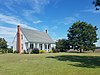
This list includes properties and districts listed on the National Register of Historic Places in Granville County, North Carolina. Click the "Map of all coordinates" link to the right to view a Google map of all properties and districts with latitude and longitude coordinates in the table below.

<span class="mw-page-title-main">National Register of Historic Places listings in Orange County, North Carolina</span>

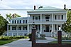
This list includes properties and districts listed on the National Register of Historic Places in Orange County, North Carolina. Click the "Map of all coordinates" link to the right to view an online map of all properties and districts with latitude and longitude coordinates in the table below.

<span class="mw-page-title-main">National Register of Historic Places listings in Burke County, North Carolina</span>

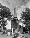
This list includes properties and districts listed on the National Register of Historic Places in Burke County, North Carolina. Click the "Map of all coordinates" link to the right to view an online map of all properties and districts with latitude and longitude coordinates in the table below.

<span class="mw-page-title-main">National Register of Historic Places listings in Henderson County, North Carolina</span>

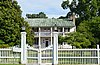
This list includes properties and districts listed on the National Register of Historic Places in Henderson County, North Carolina. Click the "Map of all coordinates" link to the right to view an online map of all properties and districts with latitude and longitude coordinates in the table below.

<span class="mw-page-title-main">National Register of Historic Places listings in Cabarrus County, North Carolina</span>

This list includes properties and districts listed on the National Register of Historic Places in Cabarrus County, North Carolina. Click the "Map of all coordinates" link to the right to view an online map of all properties and districts with latitude and longitude coordinates in the table below.

<span class="mw-page-title-main">National Register of Historic Places listings in Warren County, North Carolina</span>

This list includes properties and districts listed on the National Register of Historic Places in Warren County, North Carolina. Click the "Map of all coordinates" link to the right to view a Google map of all properties and districts with latitude and longitude coordinates in the table below.

<span class="mw-page-title-main">National Register of Historic Places listings in Martin County, North Carolina</span>

This list includes properties and districts listed on the National Register of Historic Places in Martin County, North Carolina. Click the "Map of all coordinates" link to the right to view an online map of all properties and districts with latitude and longitude coordinates in the table below.

<span class="mw-page-title-main">National Register of Historic Places listings in Bertie County, North Carolina</span>

This list includes properties and districts listed on the National Register of Historic Places in Bertie County, North Carolina. Click the "Map of all coordinates" link to the right to view an online map of all properties and districts with latitude and longitude coordinates in the table below.

<span class="mw-page-title-main">National Register of Historic Places listings in Ashe County, North Carolina</span>

This list includes properties and districts listed on the National Register of Historic Places in Ashe County, North Carolina. Click the "Map of all coordinates" link to the right to view an online map of all properties and districts with latitude and longitude coordinates in the table below.

<span class="mw-page-title-main">National Register of Historic Places listings in Vance County, North Carolina</span>

This list includes properties and districts listed on the National Register of Historic Places in Vance County, North Carolina. Click the "Map of all coordinates" link to the right to view an online map of all properties and districts with latitude and longitude coordinates in the table below.

<span class="mw-page-title-main">National Register of Historic Places listings in Cleveland County, North Carolina</span>

This list includes properties and districts listed on the National Register of Historic Places in Cleveland County, North Carolina. Click the "Map of all coordinates" link to the right to view an online map of all properties and districts with latitude and longitude coordinates in the table below.

<span class="mw-page-title-main">National Register of Historic Places listings in Transylvania County, North Carolina</span>

This list includes properties and districts listed on the National Register of Historic Places in Transylvania County, North Carolina. Click the "Map of all coordinates" link to the right to view a Google map of all properties and districts with latitude and longitude coordinates in the table below.

<span class="mw-page-title-main">National Register of Historic Places listings in Polk County, North Carolina</span>

This list includes properties and districts listed on the National Register of Historic Places in Polk County, North Carolina. Click the "Map of all coordinates" link to the right to view an online map of all properties and districts with latitude and longitude coordinates in the table below.

<span class="mw-page-title-main">National Register of Historic Places listings in Davie County, North Carolina</span>

This list includes properties and districts listed on the National Register of Historic Places in Davie County, North Carolina. Click the "Map of all coordinates" link to the right to view a Google map of all properties and districts with latitude and longitude coordinates in the table below.

<span class="mw-page-title-main">National Register of Historic Places listings in Northampton County, North Carolina</span>

This list includes properties and districts listed on the National Register of Historic Places in Northampton County, North Carolina. Click the "Map of all coordinates" link to the right to view an online map of all properties and districts with latitude and longitude coordinates in the table below.

<span class="mw-page-title-main">National Register of Historic Places listings in Beaufort County, North Carolina</span>

This list includes properties and districts listed on the National Register of Historic Places in Beaufort County, North Carolina. Click the "Map of all coordinates" link to the right to view an online map of all properties and districts with latitude and longitude coordinates in the table below.

<span class="mw-page-title-main">National Register of Historic Places listings in Madison County, North Carolina</span>

This list includes properties and districts listed on the National Register of Historic Places in Madison County, North Carolina. Click the "Map of all coordinates" link to the right to view an online map of all properties and districts with latitude and longitude coordinates in the table below.

<span class="mw-page-title-main">National Register of Historic Places listings in Tyrrell County, North Carolina</span>

This list includes properties and districts listed on the National Register of Historic Places in Tyrrell County, North Carolina. Click the "Map of all coordinates" link to the right to view a Google map of all properties and districts with latitude and longitude coordinates in the table below.

<span class="mw-page-title-main">National Register of Historic Places listings in Camden County, North Carolina</span>

This list includes properties and districts listed on the National Register of Historic Places in Camden County, North Carolina. Click the "Map of all coordinates" link to the right to view an online map of all properties and districts with latitude and longitude coordinates in the table below.

<span class="mw-page-title-main">National Register of Historic Places listings in Hoke County, North Carolina</span>

This list includes properties and districts listed on the National Register of Historic Places in Hoke County, North Carolina. Click the "Map of all coordinates" link to the right to view a Google map of all properties and districts with latitude and longitude coordinates in the table below.

References

  1. The latitude and longitude information provided in this table was derived originally from the National Register Information System, which has been found to be fairly accurate for about 99% of listings. Some locations in this table may have been corrected to current GPS standards.
  2. National Park Service, United States Department of the Interior, "National Register of Historic Places: Weekly List Actions", retrieved August 11, 2023.
  3. Numbers represent an alphabetical ordering by significant words. Various colorings, defined here, differentiate National Historic Landmarks and historic districts from other NRHP buildings, structures, sites or objects.
  4. "National Register Information System". National Register of Historic Places . National Park Service. April 24, 2008.
  5. The eight-digit number below each date is the number assigned to each location in the National Register Information System database, which can be viewed by clicking the number.