National Register of Historic Places listings in Polk County, North Carolina

Last updated

Map all coordinates using: OpenStreetMap
North Carolina Map Highlighting Polk County.PNG

This list includes properties and districts listed on the National Register of Historic Places in Polk County, North Carolina. Click the "Map of all coordinates" link to the right to view an online map of all properties and districts with latitude and longitude coordinates in the table below. [1]

Contents

Current listings


    This National Park Service list is complete through NPS recent listings posted November 24, 2023. [2]

[3] Name on the RegisterImageDate listed [4] Location City or townDescription
1 Bank of Tryon Building
Bank of Tryon Building Bank of Tryon.jpg
Bank of Tryon Building
January 17, 2008
(#07001408)
16 N. Trade St.
35°12′33″N82°14′22″W / 35.2092°N 82.2394°W / 35.2092; -82.2394 (Bank of Tryon Building)
Tryon
2 Blackberry Hill November 21, 1974
(#74001372)
East of Tryon on SR 1516
35°12′28″N82°12′04″W / 35.2078°N 82.2012°W / 35.2078; -82.2012 (Blackberry Hill)
Tryon
3 Blockhouse Site
Blockhouse Site Block House Historic Site.jpg
Blockhouse Site
October 15, 1970
(#70000466)
East of U.S. Route 176
35°11′47″N82°13′04″W / 35.1964°N 82.2178°W / 35.1964; -82.2178 (Blockhouse Site)
Tryon
4 Charlton Leland
Charlton Leland Charlton Leland.jpg
Charlton Leland
April 5, 2006
(#06000225)
229 Greenville St.
35°14′00″N82°21′05″W / 35.2333°N 82.3514°W / 35.2333; -82.3514 (Charlton Leland)
Saluda
5 Church of the Transfiguration
Church of the Transfiguration Church of the Transfiguration.jpg
Church of the Transfiguration
November 12, 1982
(#82001301)
Henderson and Charles Sts.
35°14′12″N82°20′48″W / 35.2367°N 82.3467°W / 35.2367; -82.3467 (Church of the Transfiguration)
Saluda
6 The Cotton Patch May 25, 2021
(#100006462)
426 South River Rd.
35°12′48″N82°12′13″W / 35.2132°N 82.2035°W / 35.2132; -82.2035 (The Cotton Patch)
Tryon vicinity
7 Downtown Tryon Historic District
Downtown Tryon Historic District Tryon Theater and Tryon Supply Company.jpg
Downtown Tryon Historic District
December 15, 2015
(#15000900)
Both sides of N. & S. Trade Sts., RR. right-of-way between 98 N. & 55 S. Trade Sts.
35°12′32″N82°14′19″W / 35.2089°N 82.2386°W / 35.2089; -82.2386 (Downtown Tryon Historic District)
Tryon
8 Friendly Hills June 26, 1998
(#98000731)
140 Country Club Rd.
35°13′13″N82°15′01″W / 35.2203°N 82.2503°W / 35.2203; -82.2503 (Friendly Hills)
Tryon
9 Green River Plantation
Green River Plantation Green River Plantation.jpg
Green River Plantation
March 28, 1974
(#74001370)
East of Columbus off SR 1005
35°17′12″N82°01′06″W / 35.2867°N 82.0183°W / 35.2867; -82.0183 (Green River Plantation)
Columbus
10 J. G. Hughes House
J. G. Hughes House J G Hughes House.jpg
J. G. Hughes House
May 5, 1989
(#89000347)
N. Peak St.
35°15′14″N82°11′59″W / 35.2539°N 82.1997°W / 35.2539; -82.1997 (J. G. Hughes House)
Columbus
11 John Hiram Johnson House February 7, 1994
(#94000005)
Address Restricted
Saluda
12 Rev. Joshua D. Jones House
Rev. Joshua D. Jones House Reverend Joshua D Jones House.jpg
Rev. Joshua D. Jones House
September 26, 1991
(#91001476)
NC 1526 south side, 0.4 miles (0.64 km) from NC 108
35°17′24″N82°09′51″W / 35.29°N 82.1642°W / 35.29; -82.1642 (Rev. Joshua D. Jones House)
Mill Spring
13 Lynncote
Lynncote Lynncote.jpg
Lynncote
August 30, 2010
(#10000604)
3318 Lynn Rd.
35°12′51″N82°14′29″W / 35.2142°N 82.2414°W / 35.2142; -82.2414 (Lynncote)
Tryon
14 Lynncote Historic District
Lynncote Historic District Lynncote.jpg
Lynncote Historic District
July 28, 2022
(#100007969)
3316-3525 Lynn and 39 Wilderness Rds.
35°12′51″N82°14′29″W / 35.2143°N 82.2414°W / 35.2143; -82.2414 (Lynncote Historic District)
Tryon
15 Mill Farm Inn
Mill Farm Inn Mill Farm Inn.jpg
Mill Farm Inn
January 22, 2009
(#08001366)
701 Harmon Field Rd.
35°13′24″N82°14′52″W / 35.2232°N 82.2478°W / 35.2232; -82.2478 (Mill Farm Inn)
Tryon
16 Mills-Screven Plantation
Mills-Screven Plantation Mills Screven Plantation.jpg
Mills-Screven Plantation
February 17, 1983
(#83001904)
Northeast of Tryon on SR 1509
35°13′04″N82°13′33″W / 35.2178°N 82.2258°W / 35.2178; -82.2258 (Mills-Screven Plantation)
Tryon
17 Pine Crest Inn
Pine Crest Inn Pine Crest Inn.jpg
Pine Crest Inn
April 15, 1982
(#82003500)
Pine Crest Lane
35°12′31″N82°14′02″W / 35.2086°N 82.2339°W / 35.2086; -82.2339 (Pine Crest Inn)
Tryon
18 Polk County Courthouse
Polk County Courthouse Polk County Courthouse - Columbus, NC.jpg
Polk County Courthouse
November 8, 1974
(#74001371)
Courthouse St.
35°15′05″N82°11′54″W / 35.2514°N 82.1983°W / 35.2514; -82.1983 (Polk County Courthouse)
Columbus
19 Railway Clerks' Mountain House
Railway Clerks' Mountain House Orchard Inn.jpg
Railway Clerks' Mountain House
July 28, 2000
(#00000842)
100 Orchard Inn Lane (U.S. Route 176, 0.6 miles (0.97 km) southeast of the junction with Ozone Rd.)
35°13′50″N82°20′10″W / 35.2306°N 82.3361°W / 35.2306; -82.3361 (Railway Clerks' Mountain House)
Saluda
20 Ryder Hall
Ryder Hall Ryder Hall.jpg
Ryder Hall
September 15, 2005
(#05001033)
305 Seminary St.
35°14′14″N82°20′35″W / 35.2372°N 82.3431°W / 35.2372; -82.3431 (Ryder Hall)
Saluda
21 Saluda Main Street Historic District
Saluda Main Street Historic District Saluda Historic District.jpg
Saluda Main Street Historic District
May 29, 1996
(#96000569)
Main St. from Cullipher St. to Carolina St.
35°14′10″N82°20′54″W / 35.2361°N 82.3483°W / 35.2361; -82.3483 (Saluda Main Street Historic District)
Saluda
22 Seven Hearths
Seven Hearths Seven Hearths.jpg
Seven Hearths
March 26, 1976
(#76001333)
North of Tryon at junction of U.S. Route 176 and Harmon Field Rd.
35°13′20″N82°15′04″W / 35.2222°N 82.2511°W / 35.2222; -82.2511 (Seven Hearths)
Tryon
24 Stone Hedge
Stone Hedge Modern Stone Hedge in Spring 2015.jpg
Stone Hedge
April 21, 2015
(#15000166)
222 Stone Hedge Ln.
35°14′41″N82°14′52″W / 35.2447°N 82.2477°W / 35.2447; -82.2477 (Stone Hedge)
Tryon
25 Sunnydale
Sunnydale Sunnydale.jpg
Sunnydale
December 7, 2011
(#11000890)
334 S. Trade St.
35°12′15″N82°14′16″W / 35.2042°N 82.2377°W / 35.2042; -82.2377 (Sunnydale)
Tryon
26 Tryon Country Club
Tryon Country Club Tryon Country Club.jpg
Tryon Country Club
February 5, 2013
(#12001262)
393 Country Club Rd.
35°13′07″N82°15′16″W / 35.2186°N 82.2544°W / 35.2186; -82.2544 (Tryon Country Club)
Tryon
23 Nina Simone Birthplace
Nina Simone Birthplace The Birthplace of Nina Simone.jpg
Nina Simone Birthplace
May 18, 2023
(#100007967)
30 East Livingston St.
35°12′50″N82°13′56″W / 35.2139°N 82.2322°W / 35.2139; -82.2322 (Nina Simone Birthplace)
Tryon

See also

Related Research Articles

<span class="mw-page-title-main">National Register of Historic Places listings in Granville County, North Carolina</span>

This list includes properties and districts listed on the National Register of Historic Places in Granville County, North Carolina. Click the "Map of all coordinates" link to the right to view a Google map of all properties and districts with latitude and longitude coordinates in the table below.

<span class="mw-page-title-main">National Register of Historic Places listings in Burke County, North Carolina</span>

This list includes properties and districts listed on the National Register of Historic Places in Burke County, North Carolina. Click the "Map of all coordinates" link to the right to view an online map of all properties and districts with latitude and longitude coordinates in the table below.

<span class="mw-page-title-main">National Register of Historic Places listings in Henderson County, North Carolina</span>

This list includes properties and districts listed on the National Register of Historic Places in Henderson County, North Carolina. Click the "Map of all coordinates" link to the right to view an online map of all properties and districts with latitude and longitude coordinates in the table below.

<span class="mw-page-title-main">National Register of Historic Places listings in Moore County, North Carolina</span>

This list includes properties and districts listed on the National Register of Historic Places in Moore County, North Carolina. Click the "Map of all coordinates" link to the right to view a Google map of all properties and districts with latitude and longitude coordinates in the table below.

<span class="mw-page-title-main">National Register of Historic Places listings in Warren County, North Carolina</span>

This list includes properties and districts listed on the National Register of Historic Places in Warren County, North Carolina. Click the "Map of all coordinates" link to the right to view a Google map of all properties and districts with latitude and longitude coordinates in the table below.

<span class="mw-page-title-main">National Register of Historic Places listings in Haywood County, North Carolina</span>

This list includes properties and districts listed on the National Register of Historic Places in Haywood County, North Carolina. Click the "Map of all coordinates" link to the right to view an online map of all properties and districts with latitude and longitude coordinates in the table below.

<span class="mw-page-title-main">National Register of Historic Places listings in Bertie County, North Carolina</span>

This list includes properties and districts listed on the National Register of Historic Places in Bertie County, North Carolina. Click the "Map of all coordinates" link to the right to view an online map of all properties and districts with latitude and longitude coordinates in the table below.

<span class="mw-page-title-main">National Register of Historic Places listings in Perquimans County, North Carolina</span>

This list includes properties and districts listed on the National Register of Historic Places in Perquimans County, North Carolina. Click the "Map of all coordinates" link to the right to view a Google map of all properties and districts with latitude and longitude coordinates in the table below.

<span class="mw-page-title-main">National Register of Historic Places listings in Northampton County, North Carolina</span>

This list includes properties and districts listed on the National Register of Historic Places in Northampton County, North Carolina. Click the "Map of all coordinates" link to the right to view an online map of all properties and districts with latitude and longitude coordinates in the table below.

<span class="mw-page-title-main">National Register of Historic Places listings in Scotland County, North Carolina</span>

This list includes properties and districts listed on the National Register of Historic Places in Scotland County, North Carolina. Click the "Map of all coordinates" link to the right to view an online map of all properties and districts with latitude and longitude coordinates in the table below.

This list includes properties and districts listed on the National Register of Historic Places in Avery County, North Carolina. Click the "Map of all coordinates" link to the right to view an online map of all properties and districts with latitude and longitude coordinates in the table below.

<span class="mw-page-title-main">National Register of Historic Places listings in Greene County, North Carolina</span>

This list includes properties and districts listed on the National Register of Historic Places in Greene County, North Carolina. Click the "Map of all coordinates" link to the right to view a Google map of all properties and districts with latitude and longitude coordinates in the table below.

<span class="mw-page-title-main">National Register of Historic Places listings in Mitchell County, North Carolina</span>

This list includes properties and districts listed on the National Register of Historic Places in Mitchell County, North Carolina. Click the "Map of all coordinates" link to the right to view a Google map of all properties and districts with latitude and longitude coordinates in the table below.

<span class="mw-page-title-main">National Register of Historic Places listings in Graham County, North Carolina</span>

This list includes properties and districts listed on the National Register of Historic Places in Graham County, North Carolina. Click the "Map of all coordinates" link to the right to view an online map of all properties and districts with latitude and longitude coordinates in the table below.

<span class="mw-page-title-main">National Register of Historic Places listings in Tyrrell County, North Carolina</span>

This list includes properties and districts listed on the National Register of Historic Places in Tyrrell County, North Carolina. Click the "Map of all coordinates" link to the right to view a Google map of all properties and districts with latitude and longitude coordinates in the table below.

<span class="mw-page-title-main">National Register of Historic Places listings in Columbus County, North Carolina</span>

This list includes properties and districts listed on the National Register of Historic Places in Columbus County, North Carolina. Click the "Map of all coordinates" link to the right to view an online map of all properties and districts with latitude and longitude coordinates in the table below.

<span class="mw-page-title-main">National Register of Historic Places listings in McDowell County, North Carolina</span>

This list includes properties and districts listed on the National Register of Historic Places in McDowell County, North Carolina. Click the "Map of all coordinates" link to the right to view a Google map of all properties and districts with latitude and longitude coordinates in the table below.

<span class="mw-page-title-main">National Register of Historic Places listings in Pamlico County, North Carolina</span>

This list includes properties and districts listed on the National Register of Historic Places in Pamlico County, North Carolina. Click the "Map of all coordinates" link to the right to view an online map of all properties and districts with latitude and longitude coordinates in the table below.

<span class="mw-page-title-main">National Register of Historic Places listings in Washington County, North Carolina</span>

This list includes properties and districts listed on the National Register of Historic Places in Washington County, North Carolina. Click the "Map of all coordinates" link to the right to view a Google map of all properties and districts with latitude and longitude coordinates in the table below.

<span class="mw-page-title-main">National Register of Historic Places listings in Yancey County, North Carolina</span>

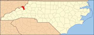
This list includes properties and districts listed on the National Register of Historic Places in Yancey County, North Carolina. Click the "Map of all coordinates" link to the right to view a Google map of all properties and districts with latitude and longitude coordinates in the table below.

References

  1. The latitude and longitude information provided in this table was derived originally from the National Register Information System, which has been found to be fairly accurate for about 99% of listings. Some locations in this table may have been corrected to current GPS standards.
  2. National Park Service, United States Department of the Interior, "National Register of Historic Places: Weekly List Actions", retrieved November 24, 2023.
  3. Numbers represent an alphabetical ordering by significant words. Various colorings, defined here, differentiate National Historic Landmarks and historic districts from other NRHP buildings, structures, sites or objects.
  4. The eight-digit number below each date is the number assigned to each location in the National Register Information System database, which can be viewed by clicking the number.