National Register of Historic Places listings in Perquimans County, North Carolina

Last updated
Map all coordinates using: OpenStreetMap  
Download coordinates as: KML  ·  GPX
North Carolina Map Highlighting Perquimans County.PNG

This list includes properties and districts listed on the National Register of Historic Places in Perquimans County, North Carolina. Click the "Map of all coordinates" link to the right to view a Google map of all properties and districts with latitude and longitude coordinates in the table below. [1]

Contents

Current listings

This National Park Service list is complete through NPS recent listings posted November 5, 2020. [2]
[3] Name on the RegisterImageDate listed [4] Location City or townDescription
1 Belvidere
Belvidere Historic American Buildings Survey, Thomas T. Waterman, Photographer July, 1940. - Exum Newby House, NC Route 37, Winfall, Perquimans County, NC HABS NC,72-WINF.V,1-1.tif
Belvidere
August 2, 1977
(#77001008)
NC 37, W of Perquimans River
36°16′08″N76°32′48″W / 36.268889°N 76.546667°W / 36.268889; -76.546667 (Belvidere)
Belvidere
2 Belvidere Historic District June 4, 1999
(#99000600)
Roughly bounded by the Perquinmans R., NC 37, NC 1200, and NC 1213
36°16′08″N76°32′17″W / 36.268889°N 76.538056°W / 36.268889; -76.538056 (Belvidere Historic District)
Belvidere
3 Church of the Holy Trinity
Church of the Holy Trinity Church of the Holy Trinity - Hertford, Perquimans County, North Carolina.jpg
Church of the Holy Trinity
June 11, 1998
(#98000688)
207 S. Church St.
36°11′14″N76°28′00″W / 36.187222°N 76.466667°W / 36.187222; -76.466667 (Church of the Holy Trinity)
Hertford
4 Cove Grove
Cove Grove Historic American Buildings Survey, Thomas T. Waterman, Photographer July, 1940. - Cove Grove, State Route 1301, Hertford, Perquimans County, NC HABS NC,72-HERF.V,2-2.tif
Cove Grove
August 7, 1974
(#74001366)
E of Hertford near SR 1301 and 1302
36°11′02″N76°25′02″W / 36.183889°N 76.417222°W / 36.183889; -76.417222 (Cove Grove)
Hertford
5 Fletcher-Skinner-Nixon House and Outbuildings
Fletcher-Skinner-Nixon House and Outbuildings Historic American Buildings Survey, Thomas T. Waterman, Photographer July, 1940. - Skinner House, State Route 1301, Hertford, Perquimans County, NC HABS NC,72-HERF.V,3-1.tif
Fletcher-Skinner-Nixon House and Outbuildings
January 21, 1994
(#93001541)
NC 1301 NE side, 0.45 miles SE of jct. with NC 1300
36°11′45″N76°25′45″W / 36.195833°N 76.429167°W / 36.195833; -76.429167 (Fletcher-Skinner-Nixon House and Outbuildings)
Hertford
6 Hertford Historic District
Hertford Historic District Baptist Church, Hertford (22149219081).jpg
Hertford Historic District
October 22, 1998
(#98001264)
Roughly bounded by the Perquimans River and W. Academy St., Hyde St., and Dobbs St.
36°11′23″N76°28′04″W / 36.189722°N 76.467778°W / 36.189722; -76.467778 (Hertford Historic District)
Hertford
7 Jonathan Hill Jacocks House April 1, 1998
(#98000276)
Jct. of New Hope Rd. and Jacocks Ln.
36°08′47″N76°15′59″W / 36.146389°N 76.266389°W / 36.146389; -76.266389 (Jonathan Hill Jacocks House)
New Hope Township
8 Land's End
Land's End Lands End - Perquimans County, North Carolina - Home of Col. James Leigh.jpg
Land's End
September 20, 1973
(#73001365)
SE of Hertford near jct. of SR 1300 and 1324
36°06′40″N76°13′17″W / 36.111111°N 76.221389°W / 36.111111; -76.221389 (Land's End)
Hertford Home of Col. James Leigh (1781-1854)
9 Mitchell-Ward House
Mitchell-Ward House Mitchell-Ward House, side view of carved gable fanlight.jpg
Mitchell-Ward House
June 25, 1999
(#99000716)
Jct. NC 1119 and NC 1002
36°16′30″N76°34′05″W / 36.275°N 76.568056°W / 36.275; -76.568056 (Mitchell-Ward House)
Belvidere
10 Myers-White House
Myers-White House Myers-White House, North-West Corner.jpg
Myers-White House
January 20, 1972
(#72000986)
NE of Bethel on SR 1347
36°07′12″N76°26′58″W / 36.120094°N 76.449486°W / 36.120094; -76.449486 (Myers-White House)
Bethel
11 Newbold-White House
Newbold-White House Newbold-White House (1730).JPG
Newbold-White House
June 24, 1971
(#71000615)
SE of Hertford off SR 1336
36°10′00″N76°26′15″W / 36.166667°N 76.4375°W / 36.166667; -76.4375 (Newbold-White House)
Hertford
12 Samuel Nixon House October 15, 1973
(#73001366)
NW of Hertford on SR 1121
36°13′03″N76°29′45″W / 36.2175°N 76.495833°W / 36.2175; -76.495833 (Samuel Nixon House)
Hertford
13 Old Neck Historic District September 6, 1996
(#96000929)
Roughly bounded by US 17, NC 1302, NC 1300, Suttons Cr., and the Perquimans River
36°11′33″N76°25′07″W / 36.1925°N 76.418611°W / 36.1925; -76.418611 (Old Neck Historic District)
Hertford
14 Perquimans County Courthouse
Perquimans County Courthouse Perquimans County Courthouse, Hertford, North Carolina.jpg
Perquimans County Courthouse
May 10, 1979
(#79001743)
Church St.
36°11′21″N76°27′55″W / 36.189167°N 76.465278°W / 36.189167; -76.465278 (Perquimans County Courthouse)
Hertford
15 Stockton
Stockton Historic American Buildings Survey, FRONT FACADE. - Stockton, State Route 1329, Hertford, Perquimans County, NC HABS NC,72-HERF.V,7-1.tif
Stockton
June 7, 1974
(#74001368)
S of Woodville
36°12′57″N76°19′06″W / 36.215833°N 76.318333°W / 36.215833; -76.318333 (Stockton)
Woodville
16 Sutton-Newby House
Sutton-Newby House Historic American Buildings Survey, Thomas T. Waterman, Photographer July, 1940. - Davis House, State Route 1300, New Hope, Perquimans County, NC HABS NC,72-NEHOP.V,3-1.tif
Sutton-Newby House
September 10, 1974
(#74001367)
E of Hertford
36°11′16″N76°22′56″W / 36.187778°N 76.382222°W / 36.187778; -76.382222 (Sutton-Newby House)
Hertford
17 Isaac White House
Isaac White House Historic American Buildings Survey, Thomas T. Waterman, Photographer July, 1940 FRONT VIEW. - Thomas White House, State Route 1339, Bethel, Perquimans County, NC HABS NC,72-BETH.V,7-1.tif
Isaac White House
March 23, 1979
(#79001742)
NE of Bethel on SR 1339
36°07′38″N76°27′39″W / 36.127281°N 76.460828°W / 36.127281; -76.460828 (Isaac White House)
Bethel
18 Winfall Historic District January 15, 2003
(#02001715)
Roughly along Main St. and Wiggins Rd.
36°13′11″N76°27′43″W / 36.219722°N 76.461944°W / 36.219722; -76.461944 (Winfall Historic District)
Winfall

See also

Related Research Articles

National Register of Historic Places listings in Alamance County, North Carolina

This list includes properties and districts listed on the National Register of Historic Places in Alamance County, North Carolina. Click the "Map of all coordinates" link to the right to view an online map of all properties and districts with latitude and longitude coordinates in the table below.

National Register of Historic Places listings in Craven County, North Carolina

This list includes properties and districts listed on the National Register of Historic Places in Craven County, North Carolina. Click the "Map of all coordinates" link to the right to view an online map of all properties and districts with latitude and longitude coordinates in the table below.

National Register of Historic Places listings in Iredell County, North Carolina

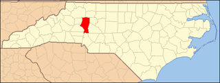
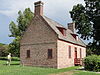
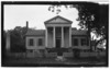
This list includes properties and districts listed on the National Register of Historic Places in Iredell County, North Carolina. Click the "Map of all coordinates" link to the right to view an online map of all properties and districts with latitude and longitude coordinates in the table below.

National Register of Historic Places listings in Burke County, North Carolina

This list includes properties and districts listed on the National Register of Historic Places in Burke County, North Carolina. Click the "Map of all coordinates" link to the right to view an online map of all properties and districts with latitude and longitude coordinates in the table below.

National Register of Historic Places listings in Franklin County, North Carolina

This list includes properties and districts listed on the National Register of Historic Places in Franklin County, North Carolina. Click the "Map of all coordinates" link to the right to view an online map of all properties and districts with latitude and longitude coordinates in the table below.

National Register of Historic Places listings in Henderson County, North Carolina

This list includes properties and districts listed on the National Register of Historic Places in Henderson County, North Carolina. Click the "Map of all coordinates" link to the right to view an online map of all properties and districts with latitude and longitude coordinates in the table below.

National Register of Historic Places listings in Hertford County, North Carolina

This list includes properties and districts listed on the National Register of Historic Places in Hertford County, North Carolina. Click the "Map of all coordinates" link to the right to view an online map of all properties and districts with latitude and longitude coordinates in the table below.

National Register of Historic Places listings in Moore County, North Carolina

This list includes properties and districts listed on the National Register of Historic Places in Moore County, North Carolina. Click the "Map of all coordinates" link to the right to view a Google map of all properties and districts with latitude and longitude coordinates in the table below.

National Register of Historic Places listings in Warren County, North Carolina

This list includes properties and districts listed on the National Register of Historic Places in Warren County, North Carolina. Click the "Map of all coordinates" link to the right to view a Google map of all properties and districts with latitude and longitude coordinates in the table below.

National Register of Historic Places listings in Nash County, North Carolina

This list includes properties and districts listed on the National Register of Historic Places in Nash County, North Carolina. Click the "Map of all coordinates" link to the right to view an online map of all properties and districts with latitude and longitude coordinates in the table below.

National Register of Historic Places listings in Martin County, North Carolina

This list includes properties and districts listed on the National Register of Historic Places in Martin County, North Carolina. Click the "Map of all coordinates" link to the right to view an online map of all properties and districts with latitude and longitude coordinates in the table below.

National Register of Historic Places listings in Haywood County, North Carolina

This list includes properties and districts listed on the National Register of Historic Places in Haywood County, North Carolina. Click the "Map of all coordinates" link to the right to view an online map of all properties and districts with latitude and longitude coordinates in the table below.

National Register of Historic Places listings in Ashe County, North Carolina

This list includes properties and districts listed on the National Register of Historic Places in Ashe County, North Carolina. Click the "Map of all coordinates" link to the right to view an online map of all properties and districts with latitude and longitude coordinates in the table below.

National Register of Historic Places listings in Vance County, North Carolina

This list includes properties and districts listed on the National Register of Historic Places in Vance County, North Carolina. Click the "Map of all coordinates" link to the right to view an online map of all properties and districts with latitude and longitude coordinates in the table below.

National Register of Historic Places listings in Cleveland County, North Carolina

This list includes properties and districts listed on the National Register of Historic Places in Cleveland County, North Carolina. Click the "Map of all coordinates" link to the right to view an online map of all properties and districts with latitude and longitude coordinates in the table below.

National Register of Historic Places listings in Stokes County, North Carolina

This list includes properties and districts listed on the National Register of Historic Places in Stokes County, North Carolina. Click the "Map of all coordinates" link to the right to view a Google map of all properties and districts with latitude and longitude coordinates in the table below.

National Register of Historic Places listings in Scotland County, North Carolina

This list includes properties and districts listed on the National Register of Historic Places in Scotland County, North Carolina. Click the "Map of all coordinates" link to the right to view an online map of all properties and districts with latitude and longitude coordinates in the table below.

National Register of Historic Places listings in Carteret County, North Carolina

This list includes properties and districts listed on the National Register of Historic Places in Carteret County, North Carolina. Click the "Map of all coordinates" link to the right to view a Google map of all properties and districts with latitude and longitude coordinates in the table below.

National Register of Historic Places listings in Pender County, North Carolina

This list includes properties and districts listed on the National Register of Historic Places in Pender County, North Carolina. Click the "Map of all coordinates" link to the right to view an online map of all properties and districts with latitude and longitude coordinates in the table below.

This list includes properties and districts listed on the National Register of Historic Places in Avery County, North Carolina. Click the "Map of all coordinates" link to the right to view an online map of all properties and districts with latitude and longitude coordinates in the table below.

References

  1. The latitude and longitude information provided in this table was derived originally from the National Register Information System, which has been found to be fairly accurate for about 99% of listings. Some locations in this table may have been corrected to current GPS standards.
  2. "National Register of Historic Places: Weekly List Actions". National Park Service, United States Department of the Interior. Retrieved on November 5, 2020.
  3. Numbers represent an alphabetical ordering by significant words. Various colorings, defined here, differentiate National Historic Landmarks and historic districts from other NRHP buildings, structures, sites or objects.
  4. The eight-digit number below each date is the number assigned to each location in the National Register Information System database, which can be viewed by clicking the number.