Adelaide Airport, South Australia

Last updated
Adelaide Airport
Adelaide,  South Australia
Australia Greater Adelaide location map.svg
Red pog.svg
Adelaide Airport
Coordinates 34°56′38″S138°31′48″E / 34.944°S 138.53°E / -34.944; 138.53 Coordinates: 34°56′38″S138°31′48″E / 34.944°S 138.53°E / -34.944; 138.53
Population
Established 1991 [3]
Postcode(s) 5950 [4]
Elevation 2 m (7 ft) [5]
Time zone ACST (UTC+9:30)
 • Summer (DST) ACST (UTC+10:30)
Location 6 km (4 mi) west of Adelaide city centre
LGA(s) City of West Torrens
State electorate(s) West Torrens [6]
Federal Division(s) Hindmarsh [7]
Mean max tempMean min tempAnnual rainfall
21.5 °C
71 °F
11.4 °C
53 °F
443.3 mm
17.5 in
Suburbs around Adelaide Airport:
Fulham Lockleys Brooklyn Park
West Beach Adelaide Airport West Richmond, Netley
Glenelg North Novar Gardens North Plympton
Footnotes Location [3] [4]
Climatic data [5]

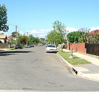
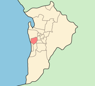
Adelaide Airport is a suburb in the City of West Torrens west of the Adelaide City Centre. The suburb was proclaimed in 1991. [8] Almost the entire area of the suburb is taken up by the Adelaide Airport and associated businesses. There is also Harbour Town shopping centre on the western side of the suburb.

City of West Torrens Local government area in South Australia

The City of West Torrens is a local government area in the western suburbs of Adelaide, South Australia. Since the 1970s the area was mainly home to many open spaces and parks, however after the mid-1990s (1993-1995) the LGA became more residential.

Adelaide Airport airport in Adelaide, Australia

Adelaide Airport is the principal airport of Adelaide, South Australia and the fifth busiest airport in Australia, servicing just over eight million passengers in the financial year ending 30 June 2017. Located adjacent to West Beach, it is approximately 6 km (3.7 mi) west of the city centre. It has been operated privately by Adelaide Airport Limited under a long-term lease from the Commonwealth Government since 29 May 1998.

Harbour Town is a shopping centre concept that incorporates multiple factory outlets in one centre. The centres especially popular with locals and tourists. As of March 2015, there were two locations owned and operated as Harbour Towns: Biggera Waters, on Queensland's Gold Coast, and at Adelaide Airport, in South Australia. A centre in Docklands, Victoria was sold in March 2014.

The suburb is bounded by Tapleys Hill Road on the west and Sir Donald Bradman Drive and the Anna Meares Bike Path on the north. The eastern and southern boundaries match the airport boundaries.

Tapleys Hill Road road in Adelaide, South Australia

Tapleys Hill Road is a major arterial road in the western suburbs of Adelaide, Australia.

Sir Donald Bradman Drive, Adelaide road in Adelaide, South Australia

Sir Donald Bradman Drive is a major arterial road that travels east–west through the western suburbs of Adelaide, South Australia. It is the main route from the Adelaide city centre to the Adelaide Airport.

The Anna Meares Bike Path is a bike path in Adelaide, Australia, adjacent to Sir Donald Bradman Drive near Adelaide Airport. It was named after the Australian track cyclist Anna Meares when it was opened by herself on 28 November 2012. The western end of the bike path is the intersection of Sir Donald Bradman Drive and Tapleys Hill Road opposite the Reece Jennings Bikeway. It extends east to Frank Collopy Court, and is intended to eventually extend east and south around the airport precinct to Watson Avenue in Netley to connect with the Captain McKenna Pathway. Ultimately, there is intended to be a 17 kilometres (11 mi) loop around Adelaide Airport. The costs for the bike path was $900,000 with the eventual extension being worth up to $1.5 million.

See also

Related Research Articles

Glandore, South Australia Suburb of Adelaide, South Australia

Glandore is a suburb of Adelaide, South Australia, partly in the City of Marion and partly in the City of West Torrens. The name is believed to come from Glandore in County Cork, Ireland, whence the family of John O'Dea, one of the original property owners of the area, came.

North Haven, South Australia Suburb of City of Port Adelaide Enfield, South Australia

North Haven is a north-western suburb of Adelaide 20 km from the CBD, in the state of South Australia, Australia and falls under the City of Port Adelaide Enfield. It is adjacent to Osborne and Outer Harbor. The postcode for North Haven is 5018. It is bounded to the north and east by Oliver Rogers and Victoria Road, to the south by Marmora Terrace and the west by Gulf St Vincent.

Fulham, South Australia Suburb of Adelaide, South Australia

Fulham is a western suburb of Adelaide, South Australia. It is located in the City of West Torrens.

Hilton, South Australia Suburb of Adelaide, South Australia

Hilton is an inner western suburb of Adelaide, South Australia. It is located in the City of West Torrens, for which it is the council seat.

Kidman Park is a western suburb of Adelaide, South Australia. It is located in the City of Charles Sturt.

Kilkenny, South Australia Suburb of Adelaide, South Australia

Kilkenny is an inner north-western suburb of Adelaide, South Australia. It is located in the City of Charles Sturt. It is named after Kilkenny, Ireland.

Hindmarsh, South Australia Suburb of Adelaide, South Australia

Hindmarsh is an inner suburb of Adelaide, South Australia. It is located in the City of Charles Sturt.

Port Noarlunga South, South Australia Suburb of Adelaide, South Australia

Port Noarlunga South is a suburb in the Australian state of South Australia located in the Adelaide metropolitan area on the coastline of Gulf St Vincent about 30 kilometres south of the state capital of Adelaide.

Seaford Meadows, South Australia Suburb of Adelaide, South Australia

Seaford Meadows is a metropolitan suburb of Adelaide, South Australia. It lies within the City of Onkaparinga and has postcode 5169. A shopping centre with a woolworths supermarket was opened in March 2014.

Henley Beach South is a coastal suburb of Adelaide, South Australia. It is located in the City of Charles Sturt.

Milang, South Australia Town in South Australia

Milang is a town and locality located in the Australian state of South Australia on the west coast of Lake Alexandrina about 71 kilometres (44 mi) south-east of the state capital of Adelaide and about 20 kilometres (12 mi) north-east of the municipal seat of Goolwa.

Semaphore Park, South Australia Suburb of City of Charles Sturt, South Australia

Semaphore Park is a suburb in the Australian state of South Australia located in the west of Adelaide on the coastline of Gulf St Vincent. The northern end of the suburb is considered to be located within the Lefevre Peninsula.

Myponga, South Australia Town in South Australia

Myponga is a settlement in South Australia. At the 2016 census, the locality had a population of 744 of which 393 lived in its town centre. Myponga is located within the federal division of Mayo, the state electoral district of Mawson, and the local government area of the District Council of Yankalilla.

Nangwarry, South Australia Town in South Australia

Nangwarry is a town and a locality in the Australian state of South Australia located about 352 kilometres (219 mi) south-east of the state capital of Adelaide and about 32 kilometres (20 mi) north-west of the regional centre of Mount Gambier.

Cygnet River, South Australia Suburb of Kangaroo Island Council, South Australia

Cygnet River is a locality in the Australian state of South Australia located on Kangaroo Island about 192 kilometres south-west of the state capital of Adelaide and about 12 kilometres from the municipal seat of Kingscote.

Cleland, South Australia Suburb of Adelaide Hills Council, South Australia

Cleland is a suburb in South Australia located in the Adelaide metropolitan area about 10 kilometres south-east of the Adelaide city centre. Its boundaries were created in October 2001, with additional land being added in 2010 from the adjoining suburb of Crafers. Its name is derived from the Cleland Conservation Park. The principal land use within the locality is conservation with the majority of its land area being occupied by the Cleland Conservation Park. Places within its extent include the summit of Mount Lofty. Cleland is located within the federal Division of Mayo, the state electoral district of Bragg and the local government areas of the Adelaide Hills Council and the City of Burnside.

Bay of Shoals, South Australia Suburb of Kangaroo Island Council, South Australia

Bay of Shoals is a locality in the Australian state of South Australia located on the north coast of Kangaroo Island overlooking the Bay of Shoals about 121 kilometres south-west of the state capital of Adelaide and about 7 kilometres north of the municipal seat of Kingscote.

Kohinoor, South Australia Suburb of Kangaroo Island Council, South Australia

Kohinoor is a locality in the Australian state of South Australia located on Kangaroo Island about 137 kilometres south-west of the state capital of Adelaide and about 20 kilometres south-east of the municipal seat of Kingscote.

Birchmore, South Australia Suburb of Kangaroo Island Council, South Australia

Birchmore is a locality in the Australian state of South Australia located on Kangaroo Island about 138 kilometres south-west of the state capital of Adelaide and about 20 kilometres south-east of the municipal seat of Kingscote.

Menzies, South Australia Suburb of Kangaroo Island Council, South Australia

Menzies is a locality in the Australian state of South Australia located on Kangaroo Island about 136 kilometres south-west of the state capital of Adelaide and about 19 kilometres west of the municipal seat of Kingscote.

References

  1. Australian Bureau of Statistics (27 June 2017). "Adelaide Airport (State Suburb)". 2016 Census QuickStats. Retrieved 23 November 2017. Blue pencil.svg
  2. Australian Bureau of Statistics (31 October 2012). "Adelaide Airport (State Suburb)". 2011 Census QuickStats. Retrieved 2 December 2015. Blue pencil.svg
  3. 1 2 "Placename Details: Adelaide Airport". Property Location Browser. Government of South Australia. 13 October 2009. SA0012016 (suburb). Archived from the original on 12 October 2016. Retrieved 4 January 2016.
  4. 1 2 "Adelaide Airport Postcode". Australian Postcode Search. Retrieved 2 December 2015.
  5. 1 2 "Summary (climate) statistics ADELAIDE AIRPORT". Commonwealth of Australia , Bureau of Meteorology . Retrieved 2 December 2015.
  6. "District of West Torrens map". Electoral Commission SA. Retrieved 2 December 2015.
  7. "Federal electoral division of Hindmarsh, boundary gazetted 16 December 2011" (PDF). Australian Electoral Commission. Retrieved 2 December 2015.
  8. "Suburbs and rural localities list" (PDF). The Government of South Australia, Department of Planning, Transport and Infrastructure. 1 May 2015. p. 2. Retrieved 4 January 2016.