Hilton, South Australia

Last updated

Hilton
Adelaide,  South Australia
St in hilton.jpg
Residential street in Hilton
Population908 (SAL 2021) [1]
Establishedc. 1849 [2]
Postcode(s) 5033 [3]
Location2.8 km (2 mi) W of Adelaide city centre [3]
LGA(s) City of West Torrens
State electorate(s) Ashford (2011) [4]
Federal division(s) Adelaide
Suburbs around Hilton:
Cowandilla Mile End Mile End
Cowandilla Hilton Mile End, Mile End South
Cowandilla Richmond Mile End South

Hilton is an inner western suburb of Adelaide, South Australia. It is located in the City of West Torrens, for which it is the council seat.

Contents

History

The Kaurna people occupied the land of the present suburb, before British colonisation of South Australia in 1836. [5]

The land now covering the suburb of Hilton was received by Matthew Davenport Hill in 1839. About ten years later, The "Village of Hilton" was laid out by his attorney, George Milner Stephen. [2]

The 1935 West Torrens Council Chambers are listed on the South Australian Heritage Register. [6]

Geography

Hilton is a rectangular suburb, lying across Sir Donald Bradman Drive. [7]

Demographics

In the 2021 Australian census, there were 908 people in Hilton. Of these, 59.7% of people were born in Australia and 58.5% of people spoke only English at home. The most common responses for religion were "No Religion" at 38.4%, and Catholic at 15.2%. [8]

Media

The local newspaper was the Weekly Times Messenger . Other regional and national newspapers such as The Advertiser and The Australian are also available. [9]

Facilities and attractions

The West Torrens Civic Centre (council offices) are on the corner of Sir Donald Bradman Drive and Brooker Terrace. The Hamra Centre Library is located next door. [7]

Hilton Plaza shopping centre is located on the corner of Sir Donald Bradman Drive and Bagot Avenue. [7]


The Hilton RSL has served the public since 1930 and overseas a large annual ANZAC Day dawn service. [10]

Hilton RSL ANZAC Day dawn service Hilton RSL 4.jpg
Hilton RSL ANZAC Day dawn service


Star Theatres

The Star Theatres One and Two are located on a corner block at 145 Sir Donald Bradman Drive. The building incorporates three performance spaces, two theatres and a studio. [11]

The first building on the site was a tin shed, erected in 1923 for soldiers returning from war, and known as the Soldiers Memorial Institute. This was replaced by a stone and brick building in 1928, which forms the basis of the current building. In the early 1930s, it catered for activities such as dances, roller skating, and "electric light cricket". [11]

In 1937 an entrance foyer, "ladies retiring room", and a projection room was added to convert the hall into a cinema, [11] which opened on 7 April 1937 as the Lyric Theatre. [12] [13] When the Windsor cinema chain took it over [11] in February 1948, it became the Windsor Theatre, [12] but by 1949 the lease had been acquired by Ozone Theatres Ltd. [14]

In 1956, the rear of the theatre was enlarged and a larger screen installed, but films were only shown on Saturdays and the hall was leased out for other uses during the week. Its name was changed to Star Theatres (indicating ownership by D. Clifford Theatres), but audiences dwindled around 1959 as drive-in theatres became more popular. the Windsor chain relinquished its lease in 1961. [11] In its later years as a cinema, it showed Greek films. [12]

In 1962, the building was leased to John Edmund and Donald Grey, who started mounting live theatre productions in a theatre in the round formation, adopting the name Theatre 62, marking the year of its establishment. The library was finally moved out of the theatre in 1970, the Soldiers Memorial Institute was disbanded, and the local council took over management of the venue. [11]

In 1981 the council purchased the old Baptist church next door and joined the two buildings, creating "Theatre 62 and The Chapel". Carclew Youth Theatre were based at the venue. In 1985 the council refurbished the building, and Mighty Good Entertainment became a partner in the management team. [11]

In 2002 it changed its name to Star Theatres One and Two. [12] Theatre One is the larger venue, seating up to 336, while Theatre Two (in the refurbished chapel [11] ) is an intimate theatre, with a seating capacity of 72. [15]

In 2023, Mighty Good Productions celebrates its 30th anniversary of holding the lease on the theatre, during this time producing at least 75 original productions. The theatres have also hosted many different productions by other groups of all kinds, including annual performances for primary, secondary schools, dance, drama and singing schools, [11] as well as Adelaide Fringe performances in March. [15] The Mighty Good Talent School is in its 44th year of teaching in 2023. [11]

Transport

Road transport uses Sir Donald Bradman Drive, connecting the suburb to Adelaide City Centre. [7]

Hilton is serviced by public transport buses run by the Adelaide Metro. As of 2022 the bus routes that serve Hilton are 163; 720; the Adelaide Airport routes J1 and J2; and school services 652 and 653. [16]

See also

Related Research Articles

<span class="mw-page-title-main">Rundle Mall</span> Pedestrianised shopping precinct in Adelaide, South Australia

Rundle Mall is a pedestrian street mall located in Adelaide, South Australia. It was opened as a pedestrian mall in September 1976 by closing the section of Rundle Street between King William Street and Pulteney Street, to vehicular traffic. The street continues as Rundle Street to the east and Hindley Street to the west.

<span class="mw-page-title-main">Brighton, South Australia</span> Suburb of Adelaide, South Australia

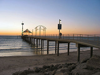
Brighton is a coastal suburb of Adelaide, South Australia, situated between Seacliff and Glenelg and aside Holdfast Bay. Some notable features of the area are the Brighton-Seacliff Yacht Club, the Brighton Surf Lifesaving Club, the Brighton Jetty, and a beach. The Windsor Theatre, constructed in 1925, is a long-standing institution.

West Beach is a seaside suburb of Adelaide, South Australia. It is located in both the City of Charles Sturt and the City of West Torrens.

<span class="mw-page-title-main">Woodville, South Australia</span> Suburb of Adelaide, South Australia

Woodville is a suburb of Adelaide, situated about 8 km (5.0 mi) northwest of Adelaide city centre. It lies within the City of Charles Sturt. The postcode of Woodville is 5011. Woodville is bound by Cheltenham Parade to the west, Torrens Road to the north, Port Road to the south and Park Street to the east, excluding the area of Cheltenham Park Racecourse. The population was 2,180 at the 2021 Australian census.

<span class="mw-page-title-main">Torrensville, South Australia</span> Suburb of Adelaide, South Australia

Torrensville is a western suburb 3 km (1.9 mi) west of the centre of Adelaide, South Australia. It was named after Irish-born economist and chairman of the South Australian Colonisation Commission, Robert Torrens.

Kensington Park is an eastern suburb of Adelaide in the City of Burnside in South Australia. It is bordered by Magill Road to the north, Glynburn Road to the east, Kensington Road to the south, and Gurrs and Shipsters Roads to the west.

Lockleys is an inner western suburb of Adelaide, in the City of West Torrens.

Brooklyn Park is a western suburb of the South Australian capital of Adelaide. It is located immediately north-east of Adelaide Airport and the Australian Federal Police (AFP) base on Sir Donald Bradman Drive. It is bound on the north by Henley Beach Road, on the east by Marion Road, and on the west by the Kooyonga Golf Club on May Terrace.

<span class="mw-page-title-main">Cowandilla, South Australia</span> Suburb of Adelaide, South Australia

Cowandilla is a western suburb in Adelaide, South Australia, in the City of West Torrens. It is located a few kilometres west of the CBD, close to Adelaide Airport. Sir Donald Bradman Drive crosses the middle of the suburb.

<span class="mw-page-title-main">Mile End, South Australia</span> Suburb of Adelaide, South Australia

Mile End is an inner western suburb of Adelaide, located in the City of West Torrens, around 2 kilometres from the Adelaide city centre. It has a census area population of 4,413 people (2011). Much of the suburb is residential, but there are small commercial areas along Henley Beach Road and South Road.

<span class="mw-page-title-main">Sir Donald Bradman Drive, Adelaide</span> Road in Adelaide, South Australia

Sir Donald Bradman Drive is a major arterial road that travels east–west through the western suburbs of Adelaide, South Australia. It is the main route from the Adelaide city centre to the Adelaide Airport.

<span class="mw-page-title-main">Hindmarsh, South Australia</span> Suburb of Adelaide, South Australia

Hindmarsh is an inner suburb of Adelaide, South Australia. It is located in the City of Charles Sturt.

<span class="mw-page-title-main">Capri Theatre</span> Heritage-listed cinema in Goodwood, Adelaide, South Australia

The Capri Theatre is a heritage-listed cinema in Goodwood, a suburb of Adelaide, South Australia, built in the Art Deco style in 1941. It was formerly called the New Star Theatre, Goodwood Star, New Curzon, and Cinema Capri.

<span class="mw-page-title-main">Richmond, South Australia</span> Suburb of Adelaide, South Australia

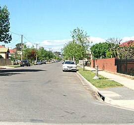
Richmond is an inner suburb of Adelaide, South Australia. It is located on Kaurna land in the City of West Torrens.

<span class="mw-page-title-main">Grote Street</span> Street in Adelaide, South Australia

Grote Street is a major street running east to west in the western half of Adelaide city centre, in Adelaide, South Australia. It is on the northern border of Chinatown and the Adelaide Central Market, and is a lively centre for shopping and restaurants. The historic Her Majesty's Theatre is located here.

<span class="mw-page-title-main">North Adelaide</span> Suburb of Adelaide, South Australia

North Adelaide is a predominantly residential precinct and suburb of the City of Adelaide in South Australia, situated north of the River Torrens and within the Adelaide Park Lands.

Adelaide Airport is a suburb in the City of West Torrens west of the Adelaide city centre. The suburb was proclaimed in 1991. Almost the entire area of the suburb is taken up by the Adelaide Airport and associated businesses. There is also Harbour Town shopping centre on the western side of the suburb.

<span class="mw-page-title-main">Town of Thebarton</span> Local government area in South Australia

The Town of Thebarton was a local government area of South Australia from 1883 until 1997. It was seated at the village of Thebarton, now an inner west suburb of Adelaide.

Ozone Theatres Ltd, formerly Ozone Amusements, was a cinema chain based in Adelaide, South Australia, from 1911 until 1951, when it sold its theatres to Hoyts. It was founded by Hugh Waterman and was jointly run by him and seven sons, including Clyde Waterman and Sir Ewen McIntyre Waterman. S.A. Theatres and Ozone Theatres were subsidiary companies, and the chain was referred to as the Ozone circuit.

References

  1. Australian Bureau of Statistics (28 June 2022). "Hilton (SA) (Suburb and Locality)". Australian Census 2021 QuickStats. Retrieved 28 June 2022.  OOjs UI icon edit-ltr-progressive.svg
  2. 1 2 "Place Names of South Australia". The Manning Index of South Australian History. State Library of South Australia. Retrieved 20 April 2011.
  3. 1 2 "Hilton, South Australia (Adelaide)". Postcodes-Australia. Postcodes-Australia.com. Retrieved 20 April 2011.
  4. "Electoral Districts – Electoral District for the 2010 Election". Electoral Commission SA. Archived from the original on 22 August 2011. Retrieved 20 April 2011.
  5. Horton, David R. (1996). "Map of Indigenous Australia". AIATSIS . Retrieved 18 December 2022.
  6. "West Torrens Council Chambers (1935 Building only)". South Australian Heritage Register. Department of Environment, Water and Natural Resources. Retrieved 11 September 2016.
  7. 1 2 3 4 Adelaide and surrounds street directory (47th ed.). UBD. 2009. ISBN   978-0-7319-2336-6.
  8. Australian Bureau of Statistics (28 June 2022). "Hilton (State Suburb)". 2021 Census QuickStats. Retrieved 15 June 2019. OOjs UI icon edit-ltr-progressive.svg CC-BY icon.svg Material was copied from this source, which is available under a Creative Commons Attribution 4.0 International License.
  9. "South Australian Newspapers". Newspapers.com.au. Australia G'day. Archived from the original on 29 April 2011. Retrieved 20 April 2011.
  10. "Hilton RSL". Hilton RSL. 4 April 2023. Retrieved 4 April 2023.
  11. 1 2 3 4 5 6 7 8 9 10 "History". Star Theatres. 11 December 2022. Retrieved 18 December 2022.
  12. 1 2 3 4 Coppock, David. "Star Theatre 1 & 2 in Hilton, AU". Cinema Treasures. Retrieved 18 December 2022.
  13. Hennessy, Antoinette (2016). Entertaining the Classes: An archaeological investigation of historic cinemas in Metropolitan Adelaide, South Australia, and their development in relation to social class, 1896-1949 (MA). Flinders University. p. 16, 96. Retrieved 18 December 2022. PDF
  14. "Hugh Waterman and sons extend the Ozone cinema chain from Adelaide's Semaphore in 1911 to eastern states". AdelaideAZ. Retrieved 17 December 2022.
  15. 1 2 "Star Theatres - 17 February - 19 March 2023". Adelaide Fringe . Retrieved 18 December 2022.
  16. "Timetables". Adelaide Metro. 12 May 2022. Archived from the original on 18 December 2022. Retrieved 18 December 2022.

Coordinates: 34°55′52″S138°34′12″E / 34.931°S 138.570°E / -34.931; 138.570