Administrative divisions of Madras Presidency

Last updated
Map of "Madras Presidency" from Pope, G. U. (1880) Pope1880MadrasPres2.jpg
Map of "Madras Presidency" from Pope, G. U. (1880)

The Madras Presidency was a province of British India comprising most of the present day Tamil Nadu and Andhra Pradesh along with a few districts and taluks of Karnataka, Kerala and Odisha. A few princely states, notably Ramnad and Pudukkottai also merged into the Presidency at some or the other time. The Presidency lasted till 1950, when it became the Madras State after India became a republic. In 1953, Telugu-speaking regions of the state split to form Andhra State. Subsequently, in 1956, Kannada- and Malayalam-speaking areas were merged with Mysore and Travancore-Cochin respectively.

Contents

Administrative Zones of the Presidency

The Districts of Madras Presidency were divided into five zones: [1]

The West Coast

The districts of the Presidency along the Arabian Sea constituted the West Coast. They were mainly the coastal districts of present-day Kerala and Karnataka states. [1]

The Deccan

These were also known as ceded districts since they were ceded to the British after the Anglo-Mysore War. The present day district of Bellary in Karnataka and Anantpur, Kadapa and Kurnool districts of Andhra Pradesh came under this zone. [2]

The Agencies

The mountainous regions of the Eastern Ghats, in present-day Coastal Andhra and Orissa, more specifically the present day Ganjam District and some districts of Andhra like Vizag, were called as Agencies. They were administered as "Tribal Belt" by British (District) Collectors, who were agents to the Governor. [2]

Northern Circars

This zone included the coastal areas of districts of present-day Coastal Andhra and Ganjam of Orissa. [2]

The Coramandel

The Southern Division of the Presidency comprising much of modern Tamil Nadu and present-day Chittoor district of Andhra Pradesh was called the Coramandel. [2]

Districts of the Presidency

Madras

The modern district of Chennai in Tamil Nadu constituted the Madras District. This was one of the earliest areas to be colonized by the British. The present day city of Chennai, then Madras was given as a grant by the Kalahasti Nayak on Francis Day in 1640. [3] [4] Madras was an important battle site during the Carnatic Wars between the English and the French. [5] For a long time, Madras was the administrative capital of the Presidency.

Chingleput

Chingleput consisted of the modern districts of Chinglepet, Tiruvallur and Conjeevaram. The town of Chinglepet went into British possession in 1763, when the Nawab of Arcot handed it over to solve his debt. [5] The town of Sardas was a Dutch possession till 1819, before it was handed over to the British. [5] The capital of the district was Karunguzhi before it was shifted to Conjeevaram in 1825 to 1835. Again, the capital became Karunguzhi between 1835 and 1859. Later in 1859, the capital was shifted to Saidapet.

North Arcot

The modern districts of Chittoor in Andhra Pradesh, Vellore, Tirupattur, Ranipet, Thiruvannamalai, Arani and few talukas off Thiruvallur (Thiruttani, pallipattu) in Tamil Nadu constituted the North Arcot District. Chittoor was the administrative headquarters city for the district. [4]

South Arcot

The modern districts of Villupuram, Kallakurichi and Cuddalore in Tamil Nadu constituted the South Arcot District. Before its possession by the British, it was part of the Carnatic along with North Arcot, Chengalpet and Nellore. [6]

Salem

The modern districts of Salem, Dharmapuri, Krishnagiri and Namakkal constituted the Salem District. [7] Salem was one of the important districts where industrial development took place, most notably Steel Industries and the TVS Group established in Hosur by T. V. Sundaram Iyengar.Salem is the Administrative headquarters of The District [8]

Coimbatore

The modern districts of Coimbatore, Erode, Tirupur and a few taluks of Kollegal Taluk of Karnataka constituted the Coimbatore District. [9] Along Salem, Coimbatore was one of the important industrial areas with noted figures like GD Naidu, G. Kuppuswami Naidu and Sri SP Narasimhulu Naidu contributing to the development of the region. Salem and Coimbatore were acquired from the Kingdom of Mysore by the British after the defeat of Dheeran chinnamalai, Tipu Sultan in 1792 and 1799 respectively. [10] [11]

Madura

The modern districts of Madurai, Theni, Dindigul, Sivaganga, Ramnathapuram, and few taluk of Virudhunagar and formed the Madura district. [12] Along with Tinnively, Madura was acquired after the bloody Polygar Wars between the British and some of the erstwhile chieftains of the Madurai royal family. Most of the Polygars who surrendered or helped the British were appointed as Zamindars in a few villages. The kingdoms of Ramnad and Sivaganga were merged into Madura as Zamindaris in 1803. [13] [14] [15]

Nilgiris

Tinnively

The modern districts of Tirunelveli, Tenkasi, Tuticorin and along with a few taluks of Virudhunagar formed the Tinnively district. [16] Many battles between Polygars and the British were fought in Tinnively which came to an end in 1801. Among the Prominent Polygars who fought the British was Veerapandiya Kattabomman. The port of Tuticorin was acquired from the Dutch. [16]

Trichinopoly

The modern districts of Tiruchirapalli, Karur, Perambalur and Ariyalur formed the Trichinopoly District. The Great Southern Railway Company was established in as Trichinopoly. According to the 1871 census, Trichinoply was the second largest city in the Madras Presidency, after its capital Madras. In 1928 Golden Rock Railway workshop was established in Ponmalai. During World War II Trichinopoly Airport was established as the second airport in Tamil Nadu. In 1938, Tata Airlines carried its first service. Trichinopoly is famous for its branded cigars. The fort of Trichy built by the Nayak kings served as an important garrison in the battle against the French.

Tanjore

The modern districts of Thanjavur, Nagapattinam, Mayiladuthurai,Tiruvarur and the Aranthangi taluk of present day Pudukkottai district formed the Tanjore District. [17] After the fall of the Cholas, the Tanjore country came under the Pandyan rule and subsequently the Delhi Sultanate before coming under Vijayanagara. Eventually a Vijayanagara Commander named Sevappa Nayadu was appointed as governor in 1532 and established the Tanjore Nayakar Kingdom which ruled till 1673. In 1674, the area came under the Marathas who ruled till 1855. After the death of the last king, Tanjore came under the British and became a part of the Presidency.

Malabar

The Malabar district included the present-day districts of Kannur, Kozhikode, Wayanad, Malappuram, Palakkad (excluding Alathur and Chittur Taluks), and Chavakad Taluk of Thrissur District (former part of Ponnani Taluk) in the northern part of Kerala state.

South Canara

The South Canara district covered the areas of the present-day districts of Dakshina Kannada and Udupi of Karnataka and the Kasaragod District of Kerala. The district was one of the most heterogeneous of Madras Presidency with Kannada, Tulu, Konkani and Malayalam being the principal languages spoken.

Notes

  1. 1 2 Thurston 1913 , pp. 8–9
  2. 1 2 3 4 Thurston 1913 , pp. 10–11
  3. "District Profile - CHENNAI". Chennai.tn.nic.in. Archived from the original on 9 April 2009. Retrieved 7 September 2009.
  4. 1 2 A Short Account of the Madras Presidency 1862 , pp. 12–13
  5. 1 2 3 A Short Account of the Madras Presidency 1862 , pp. 7–9
  6. A Short Account of the Madras Presidency 1862 , pp. 14–15
  7. A Short Account of the Madras Presidency 1862 , pp. 33–34
  8. TVS Iyengar Archived 8 March 2009 at the Wayback Machine
  9. A Short Account of the Madras Presidency 1862 , pp. 35–36
  10. "The city that is Coimbatore". The Hindu. 30 April 2005. Archived from the original on 26 July 2011. Retrieved 9 June 2010.{{cite news}}: CS1 maint: unfit URL (link)
  11. Markovits, Claude (2004). A history of modern India, 1480–1950. Anthem Press. p. 253. ISBN   9781843310044.
  12. A Short Account of the Madras Presidency 1862 , pp. 21–22
  13. "Sethupathi Tondaimans". The History of Tamil Nadu.
  14. "Holder of History:The Ramnad Sethupathis". Archived from the original on 23 October 2012.
  15. "Sethupathi Dynasty of Ramnad - Guardians of Rama Sethu". Bridge of Ram. Archived from the original on 6 October 2011.
  16. 1 2 A Short Account of the Madras Presidency 1862 , pp. 24–25
  17. A Short Account of the Madras Presidency 1862 , pp. 16–17

Related Research Articles

<span class="mw-page-title-main">Erode district</span> District of Tamil Nadu in India

Erode District is one of the 38 districts in the state of Tamil Nadu in India. It was the largest district by area in the state before the formation of Tirupur District in 2009. The headquarters of the district is Erode. It is divided into two revenue divisions, Erode and Gobichettipalayam, and is further subdivided into 10 taluks. Erode District was a part of Coimbatore District before its division into two on 17 September 1979. It covers an area of 5,722 square kilometres (2,209 sq mi), and as of 2011, had a population of 2,251,744.

<span class="mw-page-title-main">Carnatic region</span> Geographic region of southern India

The Carnatic region is the peninsular South Indian region between the Eastern Ghats and the Bay of Bengal, in the erstwhile Madras Presidency and in the modern Indian states of Tamil Nadu and southern coastal Andhra Pradesh. During the British era.

<span class="mw-page-title-main">Madras Presidency</span> Administrative subdivision of India till 1950

The Madras Presidency or Madras Province, officially called the Presidency of Fort St. George until 1935, was an administrative subdivision (province) of India. At its greatest extent, the presidency included most of southern India, including all of Andhra Pradesh, almost all of Tamil Nadu and some parts of Kerala, Karnataka, Odisha and Telangana in the modern day. The city of Madras was the winter capital of the presidency and Ooty was the summer capital.

<span class="mw-page-title-main">Dharmapuri</span> City in Tamil Nadu, India

Dharmapuri is a city in the north western part of Tamil Nadu, India. It serves as the administrative headquarters of Dharmapuri district which is the first district created in Tamil Nadu after the independence of India by splitting it from then Salem district on 2 October 1965. The city is located 50 km from Krishnagiri, 69 km from Salem, 90 km from Hosur, 117 km from Thiruvannamalai, 126 km from Bangalore and Erode, 181 km from Tiruppur, 200 km from Coimbatore and Tiruchirappalli, 300 km from Madurai and the state capital Chennai. It is located between latitudes N 11 47’ and 12 33’ and longitudes E 77 02’ and 78 40’. It is one of the major leading cultivators and producers of mangoes in the state along with Krishnagiri, and is often referred as Mango Capital of India.

<span class="mw-page-title-main">Chittoor district</span> District of Andhra Pradesh in India

Chittoor district is one of the eight districts in the Rayalaseema region of the Indian state of Andhra Pradesh. It has a population of 18,72,951 according to 2011 census of India. It is a major market centre for mangoes, grains, sugarcane, and peanuts. The district headquarters is located at Chittoor.

<span class="mw-page-title-main">Karur district</span> District of Tamil Nadu in India

Karur District is one of the 38 districts in the Indian state of Tamil Nadu. The main town in Karur District is the city of Karur, which is also the district headquarters. The district has a population of 1,064,493 with a sex-ratio of 1,015 females for every 1,000 males, according to 2011 census.

<span class="mw-page-title-main">Maruthanayagam Pillai</span> Indian military leader

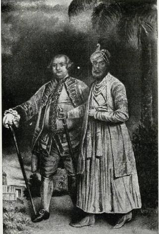
Muhammad Yusuf Khan was a commandant of the British East India Company's Madras Army. He was born in a Tamil Vellalar caste family in a village called Panaiyur in British India, what is now in Nainarkoil Taluk, Ramanathapuram District of Tamil Nadu, India. He converted to Islam and was named Muhammad Yusuf Khan. He was popularly known as Khan Sahib when he became a ruler of Madurai. He became a warrior in the Arcot troops, and later a commandant for the British East India Company troops. The British and the Arcot Nawab employed him to suppress the Polygar uprising in South India. Later he was entrusted to administer the Madurai country when the Madurai Nayak rule ended.

<span class="mw-page-title-main">Krishnagiri</span> City in Tamil Nadu, India

Krishnagiri is a city in the state of Tamil Nadu, India, and it serves as the administrative headquarters of Krishnagiri District formed in 2004. It is located at the bottom of Krishnadevaraya Hills, and the town is fully surrounded by hill rocks. It is located 250 km from Chennai, 45 km from Dharmapuri, and 90 km from Bengaluru. Krishnagiri is known as "Mango Capital of India" as mangoes are cultivated as the main crop, and the land here is extremely fertile with rich access to fresh water making it amenable to growing crops. Krishnagiri is the site of significant business and residential development. The Krishnagiri Dam was built in 1967.

<span class="mw-page-title-main">Pudukkottai State</span> Monarchy in India (1680–1948)

Pudukkottai was a kingdom and later a princely state in British India, which existed from 1680 until 1948.

<span class="mw-page-title-main">History of Madras Presidency</span>

Madras Presidency, was an administrative subdivision (presidency) of British India. At its greatest extent, Madras Presidency included much of southern India, including the present-day Indian State of Tamil Nadu, the Malabar region of North Kerala, Lakshadweep Islands, the Coastal Andhra and Rayalaseema regions of Andhra Pradesh, Brahmapur and Ganjam districts of Orissa and the Bellary, Dakshina Kannada, and Udupi districts of Karnataka. The presidency had its capital at Madras.

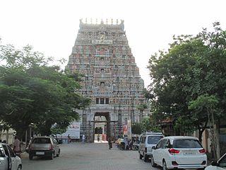
The Trichinopoly district was a district of the erstwhile Madras Presidency of British India. It covered the present-day districts of Tiruchirappalli, Karur, Ariyalur and Perambalur in the Indian state of Tamil Nadu. The administrative headquarters was the town of Trichinopoly, Trichy or Tiruchi, now known as Tiruchirappalli. The district covered an area of 2,632 square miles (6,820 km2) in 1907. It was bound by the districts of South Arcot to the north, Salem to the west, Coimbatore to the west and north-west, Tanjore to the east and Madurai to the south. The princely state of Pudukkottai remained within the jurisdiction of Trichinopoly district from 1865 to 1947.

<span class="mw-page-title-main">Tanjore District (Madras Presidency)</span>

Thanjavur District was one of the districts in the erstwhile Madras Presidency of British India. It covered the area of the present-day districts of Thanjavur, Tiruvarur, Nagapattinam, Mayiladuthurai and Aranthangi taluk, Karambakkudi taluk of Pudukkottai District in Tamil Nadu. Apart from being a bedrock of Hindu orthodoxy, Tanjore was a centre of Chola cultural heritage and one of the richest and most prosperous districts in Madras Presidency.

The Tamil Nadu District Gazetteers are a series of district encyclopedias published by the Government of Tamil Nadu.

<span class="mw-page-title-main">Coimbatore District (Madras Presidency)</span>

Coimbatore District was one of the districts of the erstwhile Madras Presidency of British India. It covered the areas of the present-day districts of Coimbatore, Erode and Tirupur and the Kollegal taluk of present-day Karnataka. It covered a total area of 20,400 square kilometres (7,860 sq mi) and was sub-divided into 10 taluks. The administrative headquarters was Coimbatore city. Most of Coimbatore's inhabitants were Tamil-speaking but there were also large numbers of Malayalam, Telugu and Kannada speaking people.

The Indian independence movement had a long history in the Tamil-speaking districts of the then Madras Presidency going back to the 18th century.

This article gives a list of the territories of the dioceses of the Catholic Church in India.

<span class="mw-page-title-main">Slavery in Madras Presidency</span>

Slavery in the Madras Presidency during the British Raj affected close to 20% of the population. Madras Presidency was an administrative subdivision (presidency) of British India. At its greatest extent, the presidency included most of southern India. The landlords were predominantly higher caste individuals. When those from the lower castes borrowed money against their land and defaulted, they entered a life of debt bondage. The slaves formed 12.2% of the total population in 1930.

This is the timeline for Southern Railway zone that encompasses over present day Tamil Nadu, Kerala and parts of Andhra Pradesh and Karnataka.

References

Bibliography