Afon Cwmnantcol

Last updated

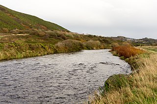
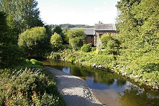
The River Cwmnantcol (Afon Cwmnantcol in Welsh) is a river in North Wales.

Welsh language Brythonic language spoken natively in Wales

Welsh is a Brittonic language of the Celtic branch of the Indo-European language family. It is spoken natively in Wales, by some in England, and in Y Wladfa. Historically, it has also been known in English as 'British', 'Cambrian', 'Cambric' and 'Cymric'.

River Natural flowing watercourse

A river is a natural flowing watercourse, usually freshwater, flowing towards an ocean, sea, lake or another river. In some cases a river flows into the ground and becomes dry at the end of its course without reaching another body of water. Small rivers can be referred to using names such as stream, creek, brook, rivulet, and rill. There are no official definitions for the generic term river as applied to geographic features, although in some countries or communities a stream is defined by its size. Many names for small rivers are specific to geographic location; examples are "run" in some parts of the United States, "burn" in Scotland and northeast England, and "beck" in northern England. Sometimes a river is defined as being larger than a creek, but not always: the language is vague.

North Wales unofficial region of Wales, United Kingdom

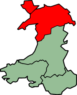
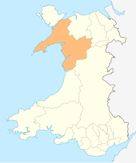
North Wales is an unofficial region of Wales. Retail, transport and educational infrastructure are centred on Wrexham, Rhyl, Colwyn Bay, Llandudno and Bangor. It is bordered to the rest of Wales with the counties of Ceredigion and Powys, and to the east by the English counties of Shropshire, Merseyside, and Cheshire. People from North Wales are sometimes referred to as "Gogs", derived from "gogledd" - the Welsh for "north".

It is about 3 miles (5 kilometres) long and has its source at the head of Cwm Nantcol below Rhinog Fawr and Y Llethr. It flows north-west from its source and joins the Afon Artro at Pentre Gwynfryn.

Cwm Nantcol is a valley in the Ardudwy area of the county of Gwynedd in Wales.

Rhinog Fawr mountain in United Kingdom

Rhinog Fawr is a mountain in Snowdonia, North Wales and forms part of the Rhinogydd range. It is the third highest summit of the Rhinogydd, losing out to Y Llethr and Diffwys respectively. Its smaller cousin Rhinog Fach lies to the south, separated by the pass of Bwlch Drws Ardudwy, while its other neighbour, Moel Ysgyfarnogod lies to the north.

Y Llethr mountain in United Kingdom

Y Llethr is the highest mountain in the Rhinogydd range of Snowdonia, in north Wales. The summit consists of a flat grassy top marked only by a small cairn. The summit is more in keeping with its southern flanks than its rugged northern approach.

Related Research Articles

Afon Mawddach river in Wales, United Kingdom

The Afon Mawddach is a river in Gwynedd, Wales, which has its source in a wide area SH820300 north of Dduallt in Snowdonia. It is 28 miles (45 km) in length, and is much branched; many of the significant tributaries are of a similar size to the main river. The catchment area is bounded to the east by the Aran Fawddwy massif and to the west and north by the Harlech dome which forms a watershed just south of Llyn Trawsfynydd.

River Ystwyth river in the United Kingdom

The River Ystwyth is a river in the county of Ceredigion, Wales. The length of the main river is 20.5 miles (33.0 km). Its catchment area covers 75 square miles (190 km2). Its source is a number of streams that include the Afon Diliw, located on the west slopes of Plynlimon on the border of Ceredigion and Powys in the Cambrian Mountains.

Afon Ogwen river in the United Kingdom

The Afon Ogwen is a river in north-west Wales draining from some of the greatest peaks in Snowdonia before discharging to the sea on the eastern side of Bangor, Gwynedd.

Afon Glaslyn river in North Wales

The Afon Glaslyn is a river in Gwynedd, north-west Wales. While not of great significance in terms of its length, it is one of Gwynedd's primary rivers, and has greatly influenced the landscape in which it flows.

Afon Clarach

The Afon Clarach is a small river discharging into Cardigan Bay north of Aberystwyth. It flows through a largely agricultural and forested landscape except in its lowest reaches where its banks are crowded with holiday developments. The Clarach is formed at the confluence of the Afon Stewi and Nant Seilo at Penrhyncoch, with both their headwaters originating in low hills at the edge of the Plynlimon range. The course of the river takes it past the Institute of Biological, Environmental and Rural Sciences, and the village of Bow Street. Between Bow Street and Llangorwen, the river is joined by the Bow Street Brook.

River Dyfi river in Wales, United Kingdom

The River Dyfi, is a river in Mid Wales. It is approximately 30 miles (48 km) long. Its estuary forms the border between the counties of Gwynedd and Ceredigion, and its lower reaches have historically been considered the boundary between North and South Wales.

Afon Colwyn river in North Wales

The Afon Colwyn is a small river in Gwynedd, north-west Wales, a tributary of the Afon Glaslyn.

River Artro river in north Wales

The River Artro is a river in Gwynedd, Wales.

Afon Mynach river in the United Kingdom

The Afon Mynach is a small river in Ceredigion, Wales.

Afon Cych is a tributary of the River Teifi in south-west Wales. It is 13 km long, passes through a number of small settlements on the border between Pembrokeshire and Carmarthenshire, and is significant in Welsh legend.

Afon Rhythallt river in the United Kingdom

The River Rhythallt is a river in Gwynedd, North Wales whose source is Llyn Padarn. It flows in a northwesterly direction past the village of Brynrefail, Gwynedd and changes its name to Afon Seiont downstream of Pont Rhythallt in Llanrug. The Afon Seiont eventually reaches the sea at Caernarfon. The river has a broad flood plain which occasionally threatens homes in the village of Cwm-y-Glo.

River Dysynni river in the United Kingdom

The River Dysynni is a river in mid Wales. Its source is the Tal-y-llyn Lake just south of the Cadair Idris massif and its mouth is in the Cardigan Bay area of the Irish Sea to the north of Tywyn. It measures about 16 mi (26 km) in length.

Afon Dulas river in Gwynedd, Wales

The Afon Dulas is a river forming the border between Merionethshire/Gwynedd and Montgomeryshire/Powys in Wales.

Afon Fathew human settlement in United Kingdom

The Afon Fathew is a river in Gwynedd, north-west Wales. The river is downstream from the Dolgoch Falls which is a popular nature site, and is followed for much of its course by the Talyllyn Railway.

River Dulas river in Wales

The River Dulas is a tributary of the River Teifi and has its source near the village of Llangybi, Ceredigion, Wales. Its confluence with the Teifi is near Lampeter.

Afon Leri river in the United Kingdom

The Afon Leri is a river in Ceredigion, Wales. It rises at Llyn Craig-y-Pistyll and is joined at Talybont by Afon Ceulan before passing behind Borth to its mouth in the Dyfi estuary at Ynyslas.

Afon Tanat river in the United Kingdom

Afon Tanat is a river in northern Powys, Wales. Its source is close to the Cyrniau Nod mountain, to the north of Lake Vyrnwy. The river flows in a generally east-south-east direction until it joins the River Vyrnwy near Llansantffraid-ym-Mechain. For a short distance prior to its confluence it flows within western Shropshire, England.

Afon Iwrch

The Afon Iwrch is a river near Llanrhaeadr-ym-Mochnant in Clwyd, Wales. It is a tributary of the River Tanat and is 8.9 miles (14.4 km) in length. Its headwaters lie on the eastern slopes of Cadair Berwyn, the highest peak of the Berwyn range, and the river flows broadly southeastwards to join the River Tanat, itself a tributary of the River Vyrnwy.

Afon Irfon river in Powys, United Kingdom

Afon Irfon is a river in Powys, Wales. It flows from the upper slopes of Bryn Garw in the Cambrian Mountains, through the Abergwesyn Valley, past the Nant Irfon National Nature Reserve in the hills above the village of Abergwesyn, and through Llanwrtyd Wells to its confluence with the River Wye at Builth Wells. The source of the Irfon is in the so-called 'Desert of Wales'.

References

    Coordinates: 52°49′15″N4°04′27″W / 52.82071°N 4.0743°W / 52.82071; -4.0743

    Geographic coordinate system Coordinate system

    A geographic coordinate system is a coordinate system that enables every location on Earth to be specified by a set of numbers, letters or symbols. The coordinates are often chosen such that one of the numbers represents a vertical position and two or three of the numbers represent a horizontal position; alternatively, a geographic position may be expressed in a combined three-dimensional Cartesian vector. A common choice of coordinates is latitude, longitude and elevation. To specify a location on a plane requires a map projection.