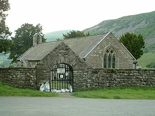
Llanfihangel-y-Pennant is a hamlet and wider, very sparsely populated community in the Meirionnydd area of Gwynedd in Wales. It is located in the foothills of Cadair Idris, and has a population of 402, reducing to 339 at the 2011 Census.
Cilycwm is a village and parish located in Carmarthenshire, Wales. The community population taken at the 2011 census was 487.

Llandre, or Llanfihangel Genau'r Glyn, is a village in Ceredigion, Wales. It lies 5 miles north of Aberystwyth in the north-west of the county, on the road from Rhydypennau to Borth. To the north of the community lies the village of Dôl-y-bont. The community is called Geneu'r Glyn.

Lledrod is a village and community in Ceredigion, Wales. The village is situated on the A485 road from Llanilar to Tregaron, where it crosses the valley of the River Wyre. The parish is divided into Lledrod Isaf and Lledrod Uchaf ; Lledrod village is located in the former, Swyddffynnon village is situated in the latter. The name 'Lledrod' is a contraction of Llanfihangel-Lledrod, which derives from Llanfihangel Llether-troed, meaning 'the church of St Michael at the foot of the slope'. The community includes the small settlements of Tyncelyn and Blaenpennal.

Llanfihangel Gobion is a village and rural parish of Monmouthshire, Wales, lying within the administrative community of Llanover.
Llanfihangel(English: St Michael's Church) can refer to the following places in Wales:

Llanrug is a large village and community in Gwynedd, north-west Wales. It lies about 4 miles (6.4 km) to the east of Caernarfon, 7 miles (11 km) south of Bangor and 3 miles (4.8 km) northwest of Llanberis. It is the largest populated village in the Arfon area of Gwynedd, Wales. The old name of the village was Llanfihangel-y-Rug, derived from Eglwys Sant Mihangel, which is situated about half a mile west of the village. It has a Welsh-speaking community of approximately 88%, the highest in Wales, and a population of 2,911.

Llanfihangel-y-Creuddyn is an ancient parish in the upper division of the hundred of Ilar, Ceredigion, West Wales, 7 miles south east from Aberystwyth, on the road to Rhayader, comprising the chapelry of Eglwys Newydd, or Llanfihangel y Creuddyn Uchaf, and the township of Llanfihangel y Creuddyn Isaf. It was also known as Lower Llanfihangel y Creuddyn, Lower Llanfihangel y Croyddin and Lower Llanfihangel y Croyddyn. This parish is situated on the rivers Ystwyth, Mynach and Rheidol and intersected by various other streams. An ancient parish was a village or group of villages or hamlets and the adjacent lands. Originally they held ecclesiastical functions, but from the sixteenth century onwards they also acquired civil roles. The parish may have been established as an ecclesiastical parish. Originally a medieval administrative unit, after 1597 ecclesiastical units acquired civil functions with the Elizabethan Poor Laws, which made the parishes responsible for welfare. The civil function was exercised through vestry meetings which administered the Poor Law and were responsible for local roads and bridges.

Cwmdu or Llanfihangel Cwmdu is a small village and community situated in the heart of the Black Mountains in Powys, Wales. Its name is derived from the Welsh language "Cwm Du", which means 'Black Valley'. It is located on the A479 Talgarth to Tretower road. Nearby towns include Crickhowell and Abergavenny. The population of the community, Llanfihangel Cwmdu with Bwlch and Cathedine, which includes Cwmdu and nearby villages Bwlch, and Tretower. Cathedine is actually in the neighbouring community of Llangors. as of the 2011 UK Census was 1026. It is in the historic county of Brecknockshire.

Llanfihangel Tor-y-Mynydd is a small rural village in the community of Devauden, Monmouthshire, Wales. It is located within the Vale of Usk, about 9 miles south west of Monmouth and 6 miles east of the town of Usk, between the villages of Devauden and Llansoy.

Garndolbenmaen, known colloquially as Garn, is a village in the county of Gwynedd, Wales. It lies near the A487, approximately 6 miles north west of Porthmadog, in the community of Dolbenmaen, which has a population of 1,300. The closest villages are Dolbenmaen and Bryncir. The Papur Bro, the local Welsh language paper, is called Y Ffynnon . The village itself has a population of around 300.

Dolbenmaen is a village and community in the Welsh county of Gwynedd, located in Eifionydd, of which it was the administrative centre until 1239. The community includes the villages of Bryncir, Cenin, Garndolbenmaen, Golan, Llanfihangel-y-Pennant, Penmorfa, Pentrefelin, and the hamlet of Prenteg. It has a population of 1,300, increasing slightly to 1,343 at the 2011 Census. The summit of Moel Hebog is shared between Beddgelert and Dolbenmaen. It is a sparsely populated area and covers nearly 100 square kilometres.

The Afon Dwyfor is a river in Gwynedd, north-west Wales, in total the river is 12+1⁄2 miles (20.1 km) in length. It rises in Cwm Dwyfor at the head of Cwm Pennant, gathers to itself numerous streams which drain the surrounding mountains from Mynydd Graig Goch in the west to Moel Hebog in the east, then flows southwest towards Dolbenmaen and out of the Snowdonia National Park.

Tal-y-llyn, or Talyllyn, is a small hamlet and former parish in Gwynedd, Wales, situated at the end of Tal-y-llyn Lake close to the village of Abergynolwyn. The parish covered an area of 36,000 acres (15,000 ha). The River Dysynni flows out of the lake at this point, flowing down to enter Cardigan Bay north of Tywyn.
Llanfihangel Glyn Myfyr is a village and community in Conwy County Borough, in Wales. It is located within the historic county of Denbighshire on the Afon Alwen, at the south western edge of the Clocaenog Forest, 9.1 miles (14.6 km) north west of Corwen, 2.5 miles (4.0 km) east of Cerrigydrudion and 27.5 miles (44.3 km) south of Conwy. At the 2001 census the community had a population of 195, reducing to 189 at the 2011 census.
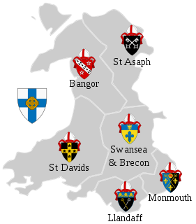
The Diocese of Bangor is a diocese of the Church in Wales in North West Wales. The diocese covers the counties of Anglesey, most of Caernarfonshire and Merionethshire and the western part of Montgomeryshire.

Llanfihangel-y-traethau was a parish in Ardudwy, Gwynedd, north-west Wales centred on a church of the same name in the village of Ynys. The original parish church was built in the 12th century on a tidal island. Later the land rose and connected the island to the mainland. Today it is part of the Bro Ardudwy ministry area, which includes Harlech, a few kilometres to the southwest, and Barmouth. The church has a window depicting Saint Tecwyn and is the start of the Saint Tecwyn's Way, a pilgrimage route ending at Saint Tecwyn's church in Llandecwyn.

The Church of St Michael, Llanfihangel Tor-y-Mynydd, Monmouthshire is a parish church with its origins in the 14th or 15th century. A Grade II* listed building, the church remains an active parish church.


